MyTopo
Triana Alabama US Topo Map
Couldn't load pickup availability
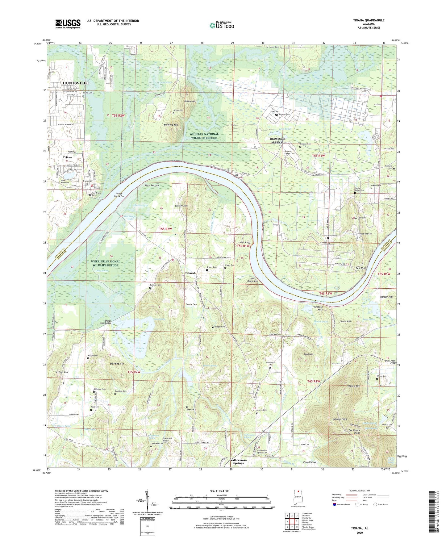
2024 topographic map quadrangle Triana in the state of Alabama. Scale: 1:24000. Based on the newly updated USGS 7.5' US Topo map series, this map is in the following counties: Morgan, Madison. The map contains contour data, water features, and other items you are used to seeing on USGS maps, but also has updated roads and other features. This is the next generation of topographic maps. Printed on high-quality waterproof paper with UV fade-resistant inks.
Quads adjacent to this one:
West: Mason Ridge
Northwest: Greenbrier
North: Madison
Northeast: Huntsville
East: Farley
Southeast: Newsome Sinks
South: Center Grove
Southwest: Somerville
This map covers the same area as the classic USGS quad with code o34086e6.
Contains the following named places: Abercrombie Dairy Farm, Bald Mountain, Ballinger Cemetery, Barkley Mountain, Barren Fork Creek, Batts - Ward Cemetery, Bell Bluff, Blue Hole, Bowers Spring, Bradford Mountain, Breeding Cemetery, Breeding Mountain, Cedar Grove Church, Cedar Hill Church, Chunn Cemetery, Chunn Hill, Clark Cemetery, Cooter Terrell Spring, Cotaco Creek, Cotaco Ferry, Cove Spring, Cribbs Pond, Crowder Slough, Currys Chapel Christian Methodist Episcopal Church, Devils Den, Dickson Cemetery, Doc Brown Point, Draper Cemetery, Draper Ferry, Dry Creek, Dry Creek Cove, First Church of Jesus Christ, Flamingo Park, Giers Branch, Givens Branch, Grantland Bridge, Grantland Cemetery, Grantland Spring, Green Grove, Green Grove Church, Green Grove Landing, Grindle Hole, Groves Cemetery, Hatton Mountain, Horton - Joiner Cemetery, Horton School, Huntsville Spring Branch, Indian Creek, Indian Creek Bar, John Black Mountain, Johnson Landing, Kay Branch, Lanier Cemetery, Leaders School, Leadus Chapel, Leadus School, Leadys School, Lees Bar, Lees Pond, Lehman Point, Lenox Spring, Lewis Bluff, Lewis Buff, Lewis Ferry, Lewis Landing, Lyle - Breeding Cemetery, Lyle Cemetery, Lynch Cemetery, Mascus Spring, Moon Bottom, Moore Cemetery, Mount Mariah Church, Mount Pleasant Church, New Mount Olive Church, New Triana Cemetery, Nicholas Lewis Plantation, Penland - Cooper Cemetery, Pine Grove Church, Pine Hill Day Camp, Plymouth Rock, Plymouth Rock Landing, Ransom Hill, Redstone Arsenal Fire Station 3, Redstone Arsenal Recreation Area, Reed Cemetery, Rock Pond, Russell Cove, Saint Paul Methodist Church, Section Mountain, Sharp Ford, Sharp Pond, Sharps Ford Bridge, Simpson Cemetery, Slaughter Ferry, Slaughter Landing, Smoot Branch, South Zion Church, Spout Spring, Sunnyside Ferry, Sunnyside Landing, Swan Pond, Talley Bottom, Talucah, Talucah Church, Talucah Ferry, Talucah Volunteer Fire Department, Tate Cemetery, The Booger Hole, The Cat Hole, Thomas Cemetery, Timmons Cemetery, Town of Triana, Triana, Triana Bar, Triana Cemetery, Triana Church, Triana Landing, Triana Police Department, Triana Recreation Area, Triana Volunteer Fire Department, Union School, Valhermoso Spring Church, Valhermoso Springs, Valhermoso Springs Cemetery, Valhermoso Springs Church, Valhermoso Springs Creek, Valhermoso Springs Holiness Church Cemetery, Walden Spring, Walling, Walling Mountain, Wallings Landing, Wilson Cemetery, Winton Cemetery Number 2, Woodward Cemetery, ZIP Code: 35775