MyTopo
Newsome Sinks Alabama US Topo Map
Couldn't load pickup availability
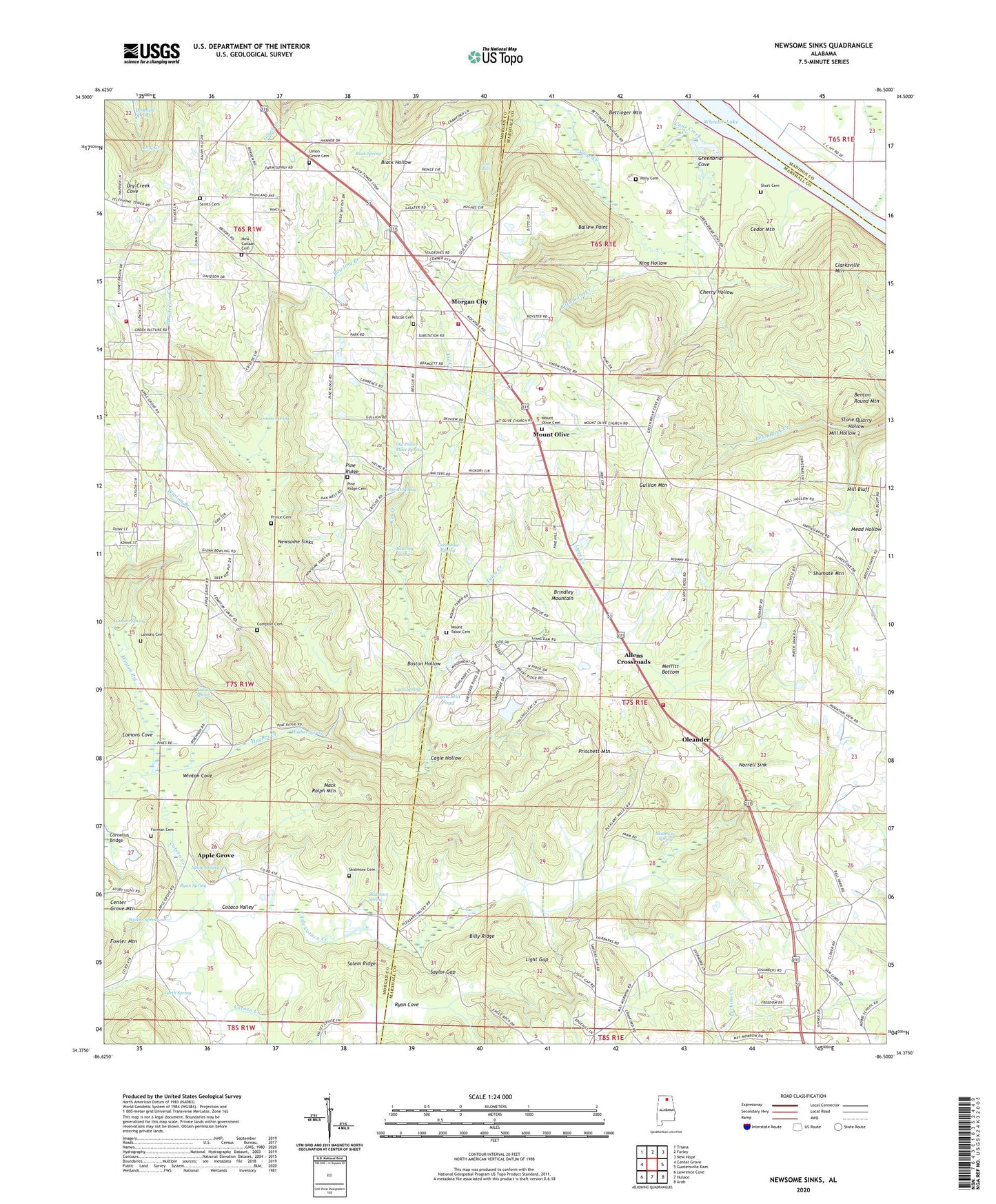
2024 topographic map quadrangle Newsome Sinks in the state of Alabama. Scale: 1:24000. Based on the newly updated USGS 7.5' US Topo map series, this map is in the following counties: Marshall, Morgan, Madison. The map contains contour data, water features, and other items you are used to seeing on USGS maps, but also has updated roads and other features. This is the next generation of topographic maps. Printed on high-quality waterproof paper with UV fade-resistant inks.
Quads adjacent to this one:
West: Center Grove
Northwest: Triana
North: Farley
Northeast: New Hope
East: Guntersville Dam
Southeast: Arab
South: Hulaco
Southwest: Lawrence Cove
This map covers the same area as the classic USGS quad with code o34086d5.
Contains the following named places: Allens Crossroads, Apple Grove, Ballew Point, Benefield Spring, Benton Round Mountain, Billy Ridge, Blowing Spring, Boston Hollow, Bowling Branch, Brindlee Mountain Volunteer Fire Department Station 1, Brindlee Mountain Volunteer Fire Department Station 2, Brindlee Mountain Volunteer Fire Department Station 3, Brindlee Mountain Volunteer Fire Department Station 4 Substation, Briscoe, Brock Chapel, Brock School, Burden-Childers Farms, Cagle Hollow, Cane Creek, Cedar Mountain, Cherry Hollow, Clarkesville Ferry, Clarksville Landing, Clarksville Mountain, Compton - Curry Cemetery, Cornelius Bridge, Cotaco Valley, Ditto Falls, Flint River Towhead, Forman Cemetery, Greenbriar Cove, Greenhaw Spring, Gullion Mountain, Henderson Creek, Highland Baptist Church, Hughes Creek, Hughes Spring, Kid Creek, King Hollow, Lamons Cemetery, Lamons Cove, Lamons Spring, Leeth Spring, Lemons Spring, Lifegate Church, Light Gap, Little Cane Creek, Little Cotaco Creek, Lynn Creek, Lynn Dam, Lynn Mill Pond, Lynn Spring, Mack Ralph Mountain, Mead Hollow, Merritt Bottom, Midway School, Mill Bluff, Mill Hollow, Morgan City, Mount Olive, Mount Olive Baptist Church Cemetery Number 2, Mount Olive Church, Mount Olive Church of Christ, Mount Olive School, Mount Tabor Baptist Church, Mount Tabor Cemetery, New Canaan Baptist Church, New Howard School, Newsome Sinks, Norrell Sink, North Parkway Church, Old New Canaan Cemetery, Old Prince Place Spring, Oleander, Oleander Church, Pine Ridge, Pine Ridge Baptist Church, Pine Ridge Cemetery, Pine Ridge School, Pleasant Valley Church, Polly Cemetery, Prince Cemetery, Pritchett Mountain, Rescue, Rescue Cemetery, Robinson Spring, Rock Spring, Ryan Cove, Ryan Spring, Saints Cemetery, Salem Ridge, Saylor Gap, Science Hill School, Short Cemetery, Shumate Mountain, Skidmore Chapel, Skidmore Chapel Cemetery, Skidmore Spring, Southern, Spout Spring, Stone Quarry Hollow, Toten Creek, Union Chapel Community Center, Union Grove Cemetery, Union Grove Church, Union Hill, Union Hill School, Venice School, Walker Spring, Winton Branch, Winton Cove, WRSA-FM (Decatur), ZIP Code: 35175