
MyTopo
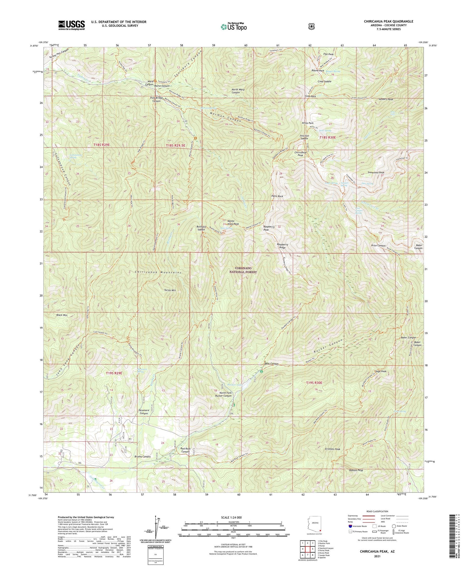
Chiricahua Peak Arizona US Topo Map
Couldn't load pickup availability
Also explore the Chiricahua Peak Forest Service Topo of this same quad for updated USFS data
2021 topographic map quadrangle Chiricahua Peak in the state of Arizona. Scale: 1:24000. Based on the newly updated USGS 7.5' US Topo map series, this map is in the following counties: Cochise. The map contains contour data, water features, and other items you are used to seeing on USGS maps, but also has updated roads and other features. This is the next generation of topographic maps. Printed on high-quality waterproof paper with UV fade-resistant inks.
Quads adjacent to this one:
West: Stanford Canyon
Northwest: Fife Peak
North: Rustler Park
Northeast: Portal
East: Portal Peak
Southeast: Apache
South: Swede Peak
Southwest: Bruno Peak
This map covers the same area as the classic USGS quad with code o31109g3.
Contains the following named places: Anita Park, Anita Spring, Baker Canyon, Bathtub Forest Camp, Bear Canyon, Bear Spring, Black Mountain, Booger Spring, Brushy Canyon, Brushy Creek, Buckskin Saddle, Camp Rucker Campground, Chiricahua Peak, Chiricahua Wilderness, Cima Park, Cima Ranger Station, Cima Saddle, Coal Pit Tank, Coronado National Forest, Cottonwood Canyon Trail Two Hundred Sixtysix, Cottonwood Creek, Cottonwood Spring, Crest Trail Two Hundred Seventy, Cummings Tank, Cypress Forest Camp, Deer Spring, Dobson Peak, Douglas Ranger District, Eagle Spring, Erickson Peak, Flys Peak, Hermitage Forest Camp, Junction Saddle, Juniper Spring, Lone Juniper Spring, Monte Vista Peak, Monte Vista Peak Lookout, Mormon Canyon, Mormon Ridge Trail Two Hundred Sixtynine, Mormon Spring, Morse Canyon, Morse Canyon Campground, North Fork Rucker Canyon, North Ward Canyon, Paint Rock, Pole Bridge Canyon, Pole Bridge Canyon Natural Area, Pole Bridge Trail Two Hundred Sixtyfour, Price Canyon Trail Two Hundred Twentyfour, Price Spring, Raspberry Peak, Raspberry Ridge, Red Rock Canyon, Round Park, Rucker Canyon Dam, Rucker Canyon Ranch, Rucker Canyon Trail Two Hundred Twentytwo, Rucker Forest Camp, Rucker Lake, Rucker Lake Campground, Rucker Ranger Station, Rucker Raspberry Ridge Trail Two Hundred Twentyeight, Sage Peak, Sanders Peak, Saulsbury Canyon, Snowshed Peak, Sycamore Canyon, Sycamore Spring, Turkey Creek Campground, Turkey Creek Ranger Station, Turkey Pen Canyon, Turtle Mountain, Turtle Mountain Trail Two Hundred Nineteen, Walnut Grove Campground, Ward Canyon, West Turkey Creek Campground, Winn Falls


