MyTopo
Russellville West Arkansas US Topo Map
Couldn't load pickup availability
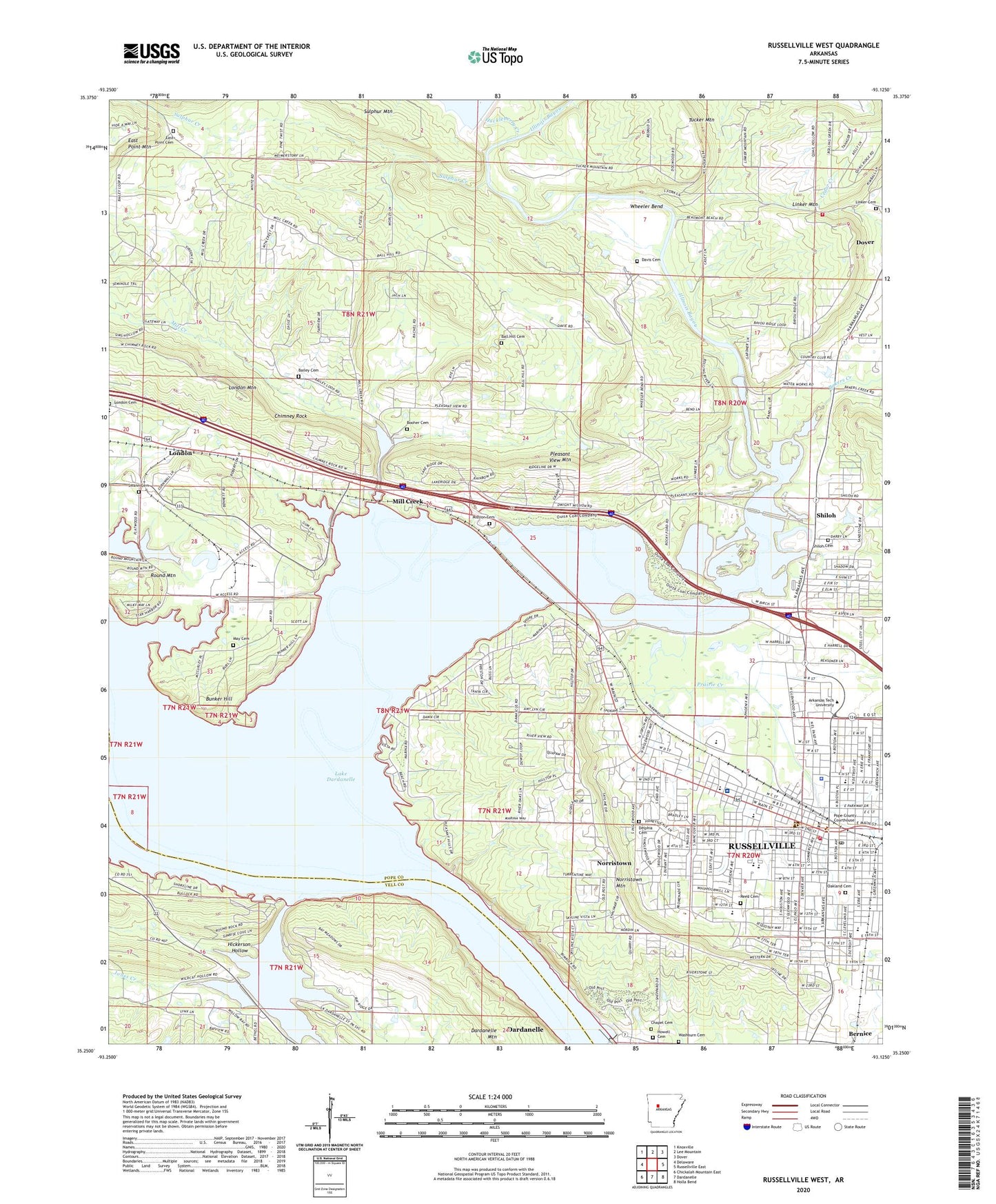
2024 topographic map quadrangle Russellville West in the state of Arkansas. Scale: 1:24000. Based on the newly updated USGS 7.5' US Topo map series, this map is in the following counties: Pope, Yell. The map contains contour data, water features, and other items you are used to seeing on USGS maps, but also has updated roads and other features. This is the next generation of topographic maps. Printed on high-quality waterproof paper with UV fade-resistant inks.
Quads adjacent to this one:
West: Delaware
Northwest: Knoxville
North: Lee Mountain
Northeast: Dover
East: Russellville East
Southeast: Holla Bend
South: Dardanelle
Southwest: Chickalah Mountain East
This map covers the same area as the classic USGS quad with code o35093c2.
Contains the following named places: All Saints Episcopal Church, AMI Saint Marys Regional Medical Center Heliport, Ano Heliport, Arkansas Game and Fish Commission Law Enforcement West Central Regional Office, Arkansas Technical University, Arkansas Technical University Department of Public Safety, Bailey Cemetery, Baker Creek, Bakers Creek, Bakers Creek Baptist Church, Ball Hill Cemetery, Ball Hill School, Bernice, Booher Cemetery, Boulder Avenue Christian Church, Bunker Hill, Cedar Creek, Central Presbyterian Church, Chactas Prairie, Chapel Cemetery, Charity Chapel Baptist Church, Chimney Rock, Church of Christ, City of London, City of Russellville, Confederate Memorial Park, Dam Site Public Use Area, Damascus Assembly of God Church, Dardanelle Boat Dock Area, Dardanelle Mountain, Davis Cemetery, Delphia Cemetery, Dwight Elementary School, Dwight Mission, East Point Baptist Church, East Point Cemetery, East Point Mountain, Edwards Chapel Christian Church, Faith Temple Church of God in Christ, First Assembly of God Church, First Baptist Church, First Christian Church, First Cumberland Presbyterian Church, First United Methodist Church, Forest E Gardner Junior High School, Green Point School, Harvest Chapel Evangelical Methodist Church, Hayes Creek, Heritage Square Shopping Center, Hickerson Hollow, House of Praise Church, Howell Cemetery, Huckleberry Creek, Illinois Bayou, Independence Street Christian Methodist Episcopal Church, James School, Jones Creek, KARV-AM (Russellville), KCJC-FM (Russellville), Kelly Heights Baptist Church, KMTC-FM (Russellville), KXRJ-FM (Russellville), Lake Dardanelle State Park, Lake Dardanelle State Park - Ouita Area, Lake Russellville, Lake Russellville Dam, Linker Cemetery, Linker Mountain Fire Department, Little Hayes Creek, London Cemetery, London Elementary School, Lone Gum School, May Cemetery, Mill Creek, Mill Creek Church of Christ, Mission Cemetery, Mountain View School, New Prospect Baptist Church, Norristown, Norristown Mountain, Oakland Cemetery, Oakland Heights Assembly of God Church, Oakland Heights Elementary School, O'Brien School, Ouitaville, Pleasant View Baptist Church, Pleasant View Mountain, Pope County Courthouse, Pope County Emergency Medical Service Station 3, Pope County Library, Prairie Creek, Reed Cemetery, Round Mountain, Round Rock Church, Round Rock School, Russellville, Russellville Boat Dock Area, Russellville City Hall, Russellville Fire Department, Russellville Fire Department Advanced Life Support, Russellville Junior High School, Russellville Male and Female Institute, Russellville Middle School, Russellville Police Department, Russellville Post Office, Russellville Seventh Day Adventist Church, Russellville Upper Elementary School, Saint Johns Catholic Church, Saint Mary's Regional Medical Center, Second Baptist Church, Sequoyah Elementary School, Sequoyah School, Shiloh, Shiloh Church, Shiloh Creek, Shiloh Missionary Baptist Church, Shiloh Park, Shiloh Williamson Cemetery, South Side Assembly of God Church, Southgate Regional Shopping Center, Sulphur Creek, Swann Cemetery, Township of Clark, Township of Illinois, Tucker Mountain, Union Hill School, Victory Missionary Baptist Church, Washburn Cemetery, West Side Church of Christ, Wheeler Bend, Williamsburg Court Shopping Center, Williamson Ford, ZIP Code: 72801