MyTopo
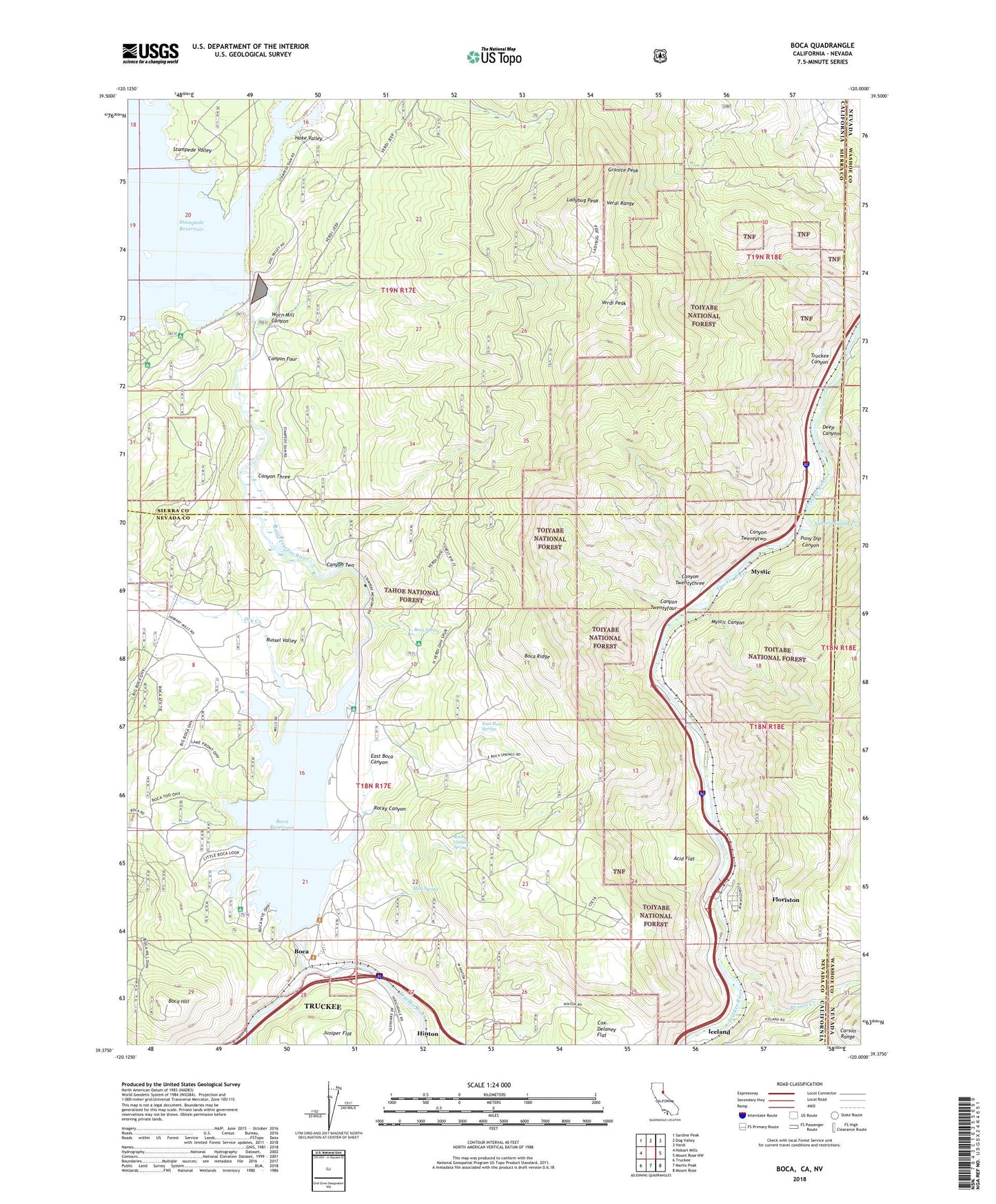
Boca California US Topo Map
Couldn't load pickup availability
Also explore the Boca Forest Service Topo of this same quad for updated USFS data
2022 topographic map quadrangle Boca in the states of California, Nevada. Scale: 1:24000. Based on the newly updated USGS 7.5' US Topo map series, this map is in the following counties: Nevada, Sierra, Washoe. The map contains contour data, water features, and other items you are used to seeing on USGS maps, but also has updated roads and other features. This is the next generation of topographic maps. Printed on high-quality waterproof paper with UV fade-resistant inks.
Quads adjacent to this one:
West: Hobart Mills
Northwest: Sardine Peak
North: Dog Valley
Northeast: Verdi
East: Mount Rose NW
Southeast: Mount Rose
South: Martis Peak
Southwest: Truckee
Contains the following named places: Acid Flat, Boca, Boca Campground, Boca Dam, Boca Hill, Boca Reservoir, Boca Rest Campground, Boca Ridge, Boca Spring, Boyington Mill Campground, Bronco, Bronco Creek, Calvada, Calvada Station, Canyon Four, Canyon Three, Canyon Twentyfour, Canyon Twentythree, Canyon Twentytwo, Canyon Two, CCC Camp, Cox-Delaney Flat, Davies Creek, Deep Canyon, Dry Creek, East Boca Canyon, East Boca Spring, Emigrant Group Campground, Farad Powerhouse, Floriston, Floriston Census Designated Place, Granite Peak, Hinton, Hirschdale Cinder Quarry, Hoke Valley, Iceland, Ladybug Peak, Logger Campground, Mills Spring, Mount Rose Trail, Mystic, Mystic Canyon, Puny Dip Canyon, Rocky Canyon, Rocky Canyon Spring, Russel Valley, Stampede Campground, Stampede Dam, Stampede Dike Dam, Stampede Valley, Stampede Vista Picnic Area, Subterranean Creek, Verdi Peak, Verdi Range, Worn Mill Canyon, ZIP Code: 96111