MyTopo
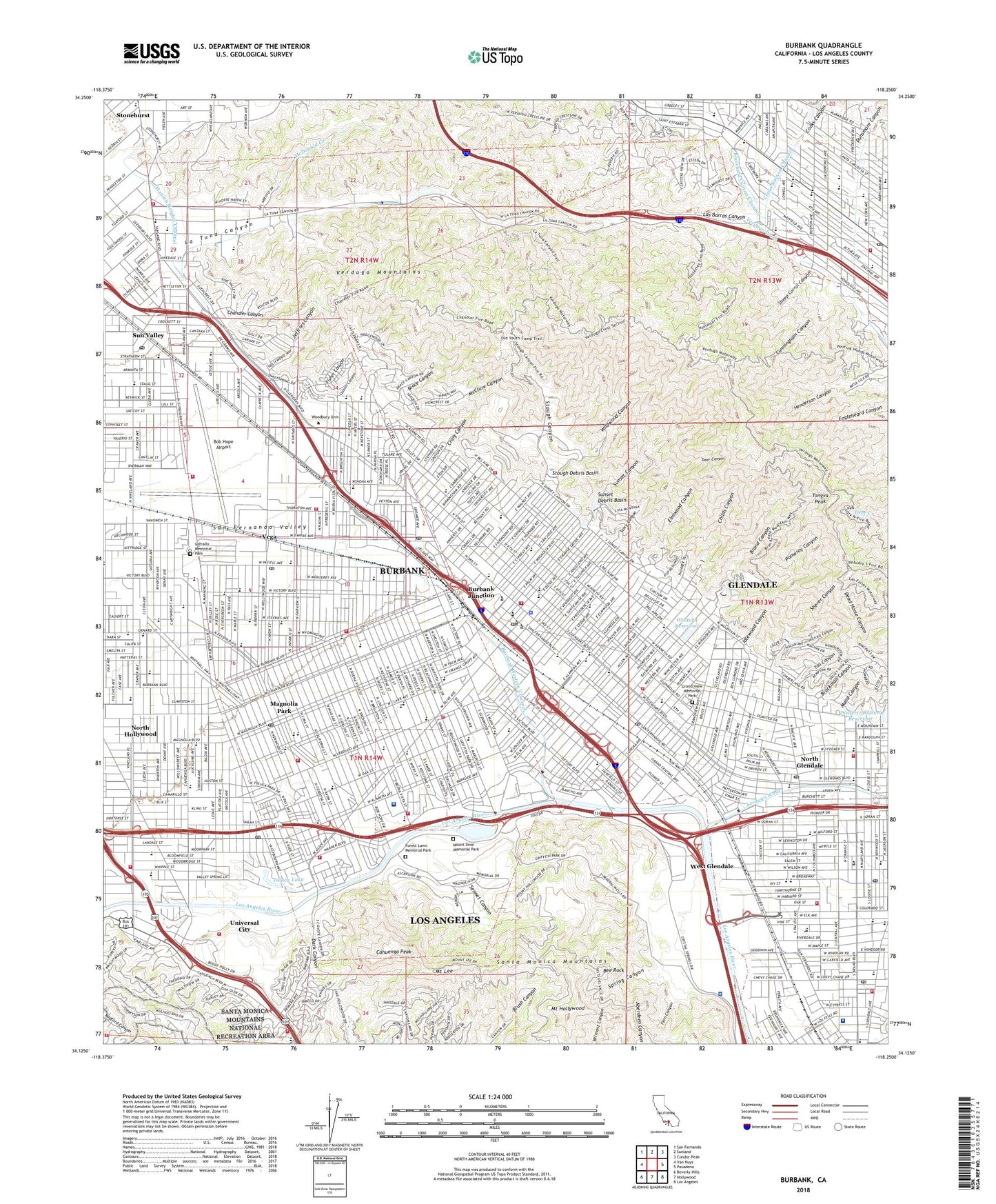
Burbank California US Topo Map
Couldn't load pickup availability
2022 topographic map quadrangle Burbank in the state of California. Scale: 1:24000. Based on the newly updated USGS 7.5' US Topo map series, this map is in the following counties: Los Angeles. The map contains contour data, water features, and other items you are used to seeing on USGS maps, but also has updated roads and other features. This is the next generation of topographic maps. Printed on high-quality waterproof paper with UV fade-resistant inks.
Quads adjacent to this one:
West: Van Nuys
Northwest: San Fernando
North: Sunland
Northeast: Condor Peak
East: Pasadena
Southeast: Los Angeles
South: Hollywood
Southwest: Beverly Hills
This map covers the same area as the classic USGS quad with code o34118b3.
Contains the following named places: 10th and Western 5-004 Dam, 90027, 90068, 91201, 91202, 91203, 91204, 91207, 91210, 91352, 91501, 91502, 91504, 91505, 91506, 91601, 91602, 91608, Abraham Lincoln Elementary School, Abraham Lincoln School, Alliance Convalescent Hospital, American Lutheran School, Anderson W Clark Magnet High School, Balboa Elementary School, Bank of America-Glendale Heliport, Bee Rock, Bel Aire Park, Bellarmine-Jefferson High School, Benjamin Franklin Elementary School, Benjamin Franklin School, Blanchard Canyon Channel, Bob Hope Airport, Brace Canyon, Brace Canyon Park, Brand Canyon, Brand Debris Dam, Brand Park, Brand Park 5-000 Dam, Bridle Trail, Broadway Convalescent Hospital, Brockman Canyon, Buena Vista Park, Burbank, Burbank Division, Burbank Health Center, Burbank High School, Burbank Junction, Burbank Western Channel, Cabrini Canyon, Cahuenga, Cahuenga Peak, Cal Haven Convalescent Hospital, Campo de Cahuenga, Casa Verdugo Convalescent Lodge, Cedar Tree Picnic Grounds, Central Branch Tujunga Wash, Cerritos Elementary School, Chamlian Armenian School, Chandler Canyon, Chandler Convalescent Hospital, Chevy Chase Park, Childs Canyon, Childs Canyon Debris Dam, City of Burbank, City of Burbank Valley Pumping Plant, Columbia Ranch, Columbus Elementary School, Cooks Canyon, Cooks Canyon Channel, Craig Canyon, Crescenta Valley Park, Crystal Springs Picnic Grounds, Cunningham Canyon, Dark Canyon, De Bell Municipal Golf Course, Deer Canyon, Dignity Health Glendale Memorial Hospital, Disney Elementary School, Disney Studios, Dreiers Sanitarium, Dunsmore Canyon, Dunsmore Canyon Channel, Dunsmore Debris Basin, Dunsmore Elementary School, Dunsmore Park, Edison Elementary School, El Paseo Cahuenga Park, Elmwood Canyon, Elmwood Debris Dam, Emerson Elementary School, Eugene Field School, Fair Elementary School, Faith Center Day School, Fehlhaberhouk Park, Fern Canyon, Ferraro Soccer Field, Fisher Canyon, Forest Lawn Memorial Park, Fremont Park, Fremont Sub-Station, George Izay Park, Glen Fed Heliport, Glendale, Glendale Central Park, Glendale Galleria Shopping Center, Glenwood Elementary School, Golden State Manor Convalescent Hospital, Golden State Palms Convalescent Hospital, Grand Central Air Terminal, Grand Central Industrial Centre, Grand View Memorial Park, Griffith Manor Park, Griffith Park, Griffith Park Aerodrome, Griffith Park Boys Camp, Grinnell Convalescent Hospital, Haines Canyon Channel, Hansen Heights Channel, Harding Golf Course, Harte Elementary School, Herbert Hoover Senior High School, Highway Highlands, Hillcrest Canyon, Hillcrest Canyon Debris Dam, Hollywoodland Girls Camp, Home School, Idlewood Canyon, Incarnation School, Jefferson Avenue Pumping Station, Jefferson Elementary School, Jefferson-Bellarmine Elementary School, Jeffries Canyon, Joaquin Miller Park, John Burroughs Senior High School, Johnny Carson Park, Jordan Middle School, KROQ-FM (Pasadena), La Paco, La Tuna Canyon, La Tuna Canyon Lateral, La Tuna Debris Dam, Lakeside Golf Club, Las Barras Canyon, Los Angeles County, Los Angeles Equestrian Center, Los Angeles Zoo, Luther Burbank Middle School, Lutheran School of the Foothills, Magnolia Park, Magnolia Park General Hospital, Mand Canyon, Mann School, Mark Keppel Elementary School, McCambridge Park, McCarthy School, McClure Canyon, McDonald Creek, McNeil, Milford Mini Park, Mineral Wells Picnic Area, Mount Hollywood, Mount Lee, Mount Sinai Memorial Park, Mountain View Park, NBC-TV Heliport, NBC-TV Studios, New York Park, North Atwater Park, North Glendale, North Glendale Hospital, Old Zoo Picnic Area, Olive Avenue Recreation Center, Pacific Park, Palm Park, Pasko Park, Pecan Grove Picnic Area, Pelanconi Park, Pickwick Drive-In, Pickwick Recreation Center, Pioneer Central Medical Building, Pomeroy Canyon, Providence Saint Joseph Medical Center, Providencia, Ralph Foy Park, Rancho Marketplace Shopping Center, Regency Convalescent Hospital, Reservoir Number 1 4-004 Dam, Reservoir Number 4 4-006 Dam, Reservoir Number 5 4-007 Dam, Riverdale Convalescent Hospital, Saint Joseph Medical Center Heliport, San Fernando Valley, Sennet Canyon, Sepulveda, Sheep Corral Canyon, Sherer Canyon, Spring Canyon, Story Canyon, Stough Canyon, Stough Debris Basin, Stough Debris Dam, Stough Park, Sun Valley, Sun Valley Park, Sunset Canyon, Sunset Canyon Country Club, Sunset Debris Basin, Sunset Debris Dam, Thomas Edison Elementary School, Thomas Jefferson Elementary School, Thompson Memorial Medical Center, Toll Canyon, Toluca Lake, Tongva Peak, Universal City, Universal City Studios, Upper Hollywood 6-029 Dam, Valhalla Memorial Park, Valley Park, Vega, Verdugo Hills Golf Course, Verdugo Mountains, Verdugo Recreation Center, Verdugo Wash, Vickroy Park, Victory-Vineland Recreation Center, Warner Brothers Studios, Weddington Park, West Glendale, Western Reservoir, Western Sub-Station, Whitnall Highway Park, Wildwood Canyon, Wildwood Canyon Park, Wilson Golf Course