MyTopo
Sunland California US Topo Map
Couldn't load pickup availability
Also explore the Sunland Forest Service Topo of this same quad for updated USFS data
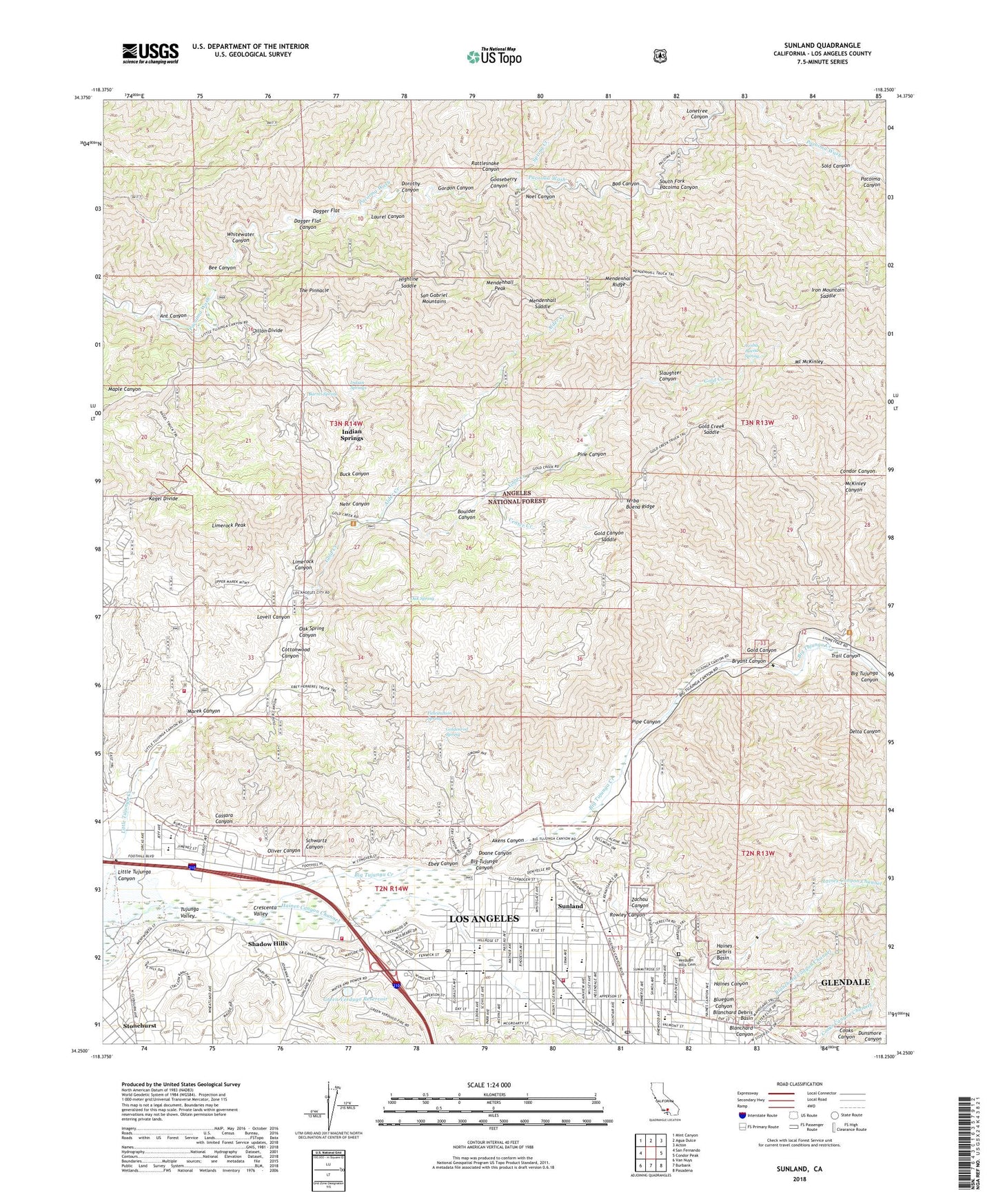
2022 topographic map quadrangle Sunland in the state of California. Scale: 1:24000. Based on the newly updated USGS 7.5' US Topo map series, this map is in the following counties: Los Angeles. The map contains contour data, water features, and other items you are used to seeing on USGS maps, but also has updated roads and other features. This is the next generation of topographic maps. Printed on high-quality waterproof paper with UV fade-resistant inks.
Quads adjacent to this one:
West: San Fernando
Northwest: Mint Canyon
North: Agua Dulce
Northeast: Acton
East: Condor Peak
Southeast: Pasadena
South: Burbank
Southwest: Van Nuys
This map covers the same area as the classic USGS quad with code o34118c3.
Contains the following named places: Akens Canyon, Alder Creek, Angels Gun Club, Ant Canyon, Apperson Elementary School, Armenian Apostolic Church, Bad Canyon, Barrel Spring, Bee Canyon, Big Tujunga Canyon, Big Tujunga Creek, Big Tujunga Guard Station, Big Tujunga Ranch, Bill Lane Camp, Blanchard Canyon, Blanchard Debris Basin, Blanchard Debris Dam, Bluegum Canyon, Bluegum Canyon Debris Dam, Bolton Hall, Boulder Canyon, Brainard Elementary School, Bryant Canyon, Buck Canyon, Camp 15 Heliport, Camp Sterling, Cassara Canyon, Center Creek, Church of Jesus Christ of Latter Day Saints, Community Christian Church, Condor Canyon, Cottonwood Canyon, Cottonwood Glen, County Camp Fifteen, Crescenta Valley, Dagger Flat, Dagger Flat Canyon, Dagger Flat Trail, Delta Canyon, Delta Flat Picnic Area, Dexter Park, Diamond Campground, Dillon Divide, Dillon Ranch, Doane Canyon, Dorothy Canyon, Dutch Louie Campground, Ebey Canyon, Faith Lutheran Church, Fascination Spring, First Baptist Church of Sunland, Gateway School, Gold Canyon, Gold Canyon Saddle, Gold Canyon Trail, Gold Creek, Gold Creek Saddle, Goldenrod Spring, Gooseberry Canyon, Gordon Canyon, Green Verdugo 6-043 Dam, Green Verdugo Reservoir, Haines Canyon, Haines Canyon Debris Dam, Haines Debris Basin, Herreres Ranch, Highline Saddle, Hillcrest Sanitarium, Honeybee Campground, Indian Springs, Iron Mountain Saddle, Kagel Canyon, Kagel Divide, Karl Holton Camp, KRCK-AM (Burbank), La Crescenta Full Gospel Church, Lake View Terrace, Lakeview Terrace Recreation Center, Lakeview Terrace Sanitarium, Laurel Canyon, Limerock Canyon, Limerock Peak, Little Landers Park, Little Tujunga Canyon, Little Tujunga Creek, Little Tujunga Station, Lonetree Canyon, Los Angeles Fire Department Station 24, Los Angeles Fire Department Station 74, Los Angeles Gateway Ranger District Fire Station, Lovell Canyon, Marek Canyon, McGroarty Park, McKinley Canyon, Mendenhall Peak, Mendenhall Ridge, Mendenhall Saddle, Middle Ranch, Mount Gleason Middle School, Mount McKinley, Mountain View Baptist Church, Nehr Canyon, Noel Canyon, Oak Spring, Oak Spring Canyon, Oak Spring Trail, Oliver Canyon, Orcas Park, Our Lady of Lourdes Church, Our Lady of Lourdes School, Pacoima Target Shooting Area, Paradise Ranch, Pine Canyon, Pinewood Elementary School, Pipe Canyon, Plainview Elementary School, Preparatory Institute of Notre Dame, Pyungsung Community Church, Rattlesnake Canyon, Redwing Lake, Rowley Canyon, Schwartz Canyon, Shadow Hills, Shadow Hills Presbyterian Church, Slaughter Canyon, Sold Canyon, South Fork Pacoima Canyon, Spring Creek, Stonehurst, Sunland, Sunland Elementary School, Sunland Mall Shopping Center, Sunland Park, Sunland Post Office, Sunland Shopping Center, Sunland-Tujunga Branch Los Angeles Public Library, The Pinnacle, Trail Canyon, Tujunga, Tujunga District Office, Tujunga Post Office, Tujunga Valley, Verdugo Hills Cemetery, Verdugo Hills Senior High School, Watts Ranch, Wesleyan Church, Whitewater Canyon, Ybarra Ranch, Yerba Buena Ridge, Yerba Buena Spring, Yerba Buena Trail, Zachau Canyon, ZIP Code: 91040