
MyTopo
Clearlake Highlands California US Topo Map
Couldn't load pickup availability
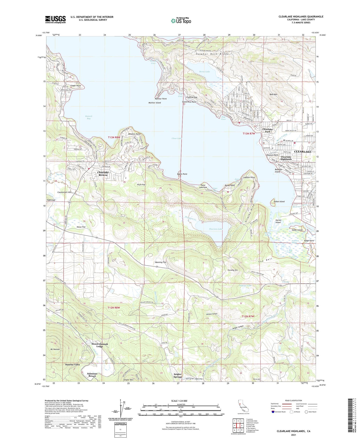
2021 topographic map quadrangle Clearlake Highlands in the state of California. Scale: 1:24000. Based on the newly updated USGS 7.5' US Topo map series, this map is in the following counties: Lake. The map contains contour data, water features, and other items you are used to seeing on USGS maps, but also has updated roads and other features. This is the next generation of topographic maps. Printed on high-quality waterproof paper with UV fade-resistant inks.
Quads adjacent to this one:
West: Kelseyville
Northwest: Lucerne
North: Clearlake Oaks
Northeast: Benmore Canyon
East: Lower Lake
Southeast: Middletown
South: Whispering Pines
Southwest: The Geysers
This map covers the same area as the classic USGS quad with code o38122h6.
Contains the following named places: Anderson Marsh, Anderson Marsh Natural Preserve, Anderson Marsh State Historic Park, Apostolic Community Church, Austin Park, Bald Mountain, Baylis Point, Beakban Island, Borax Lake, Browns Landing, Burns Valley, Burns Valley Elementary School, Burns Valley Mall Shopping Center, Calvary Chapel of Clearlake, Chamisa Gap, City of Clearlake, Clear Lake Riviera, Clear Lake Riviera Golf Course, Clearlake, Clearlake City Hall, Clearlake Community United Methodist Church, Clearlake Highlands, Clearlake Park, Clearlake Park Post Office, Clearlake Police Department, Clearlake Post Office, Clearlake Riviera Census Designated Place, Clearlake Riviera Division, Counterfeit Hill, Dry Lake, Ely Flat, First Assembly of God Church, First Baptist Church, Fraser Point, Garner Island, Gooseneck Point, Grigsby Draw, Hesse Flat, Indian Island, Jago Bay, Jones Bay, Kelseyville Fire Protection District Station 56, Konocti Bay, Konocti Conservation Camp, Konocti-Clear Lake Seaplane Base, Lake Company Sanitation District 1081 Dam, Lake County Fire Protection District Station 70 Headquarters, Lake County Fire Protection District Station 71, Lake County Fire Station, Lily Cove, Luebow Point, Manning Flat, Marsh Trail, McVicar Wildlife Sanctuary, Molesworth Creek, Monitor Island, Monitor Point, Mount Hannah, Mount Hannah Lodge, Neighborhood Pentecostal Holiness Church, North Cove, Oak Cove, Peacock Point, Perini Creek, Perini Hill, Pinkeye Lake, Pirates Cove, Plum Flat, Point Lakeview, Pomo Elementary School, Queen of Peace Roman Catholic Church, Redbud Branch Lake County Library, Redbud Park, Ridge Point, Ridge Trail, Riviera Elementary School, Riviera Estates, Riviera West, Rocky Point, Roundtop Mountain, Saint Johns Lutheran Church, Salminas Resort, Seigler Canyon, Seigler Valley, Slater Island, South Shore Senior Citizens Center, Sulphur Bank, Sulphur Bank Ridge, Sunrise Vista, The Dell, Thurston Creek, Thurston Lake, Wheeler Point, Wildcat Canyon


