MyTopo
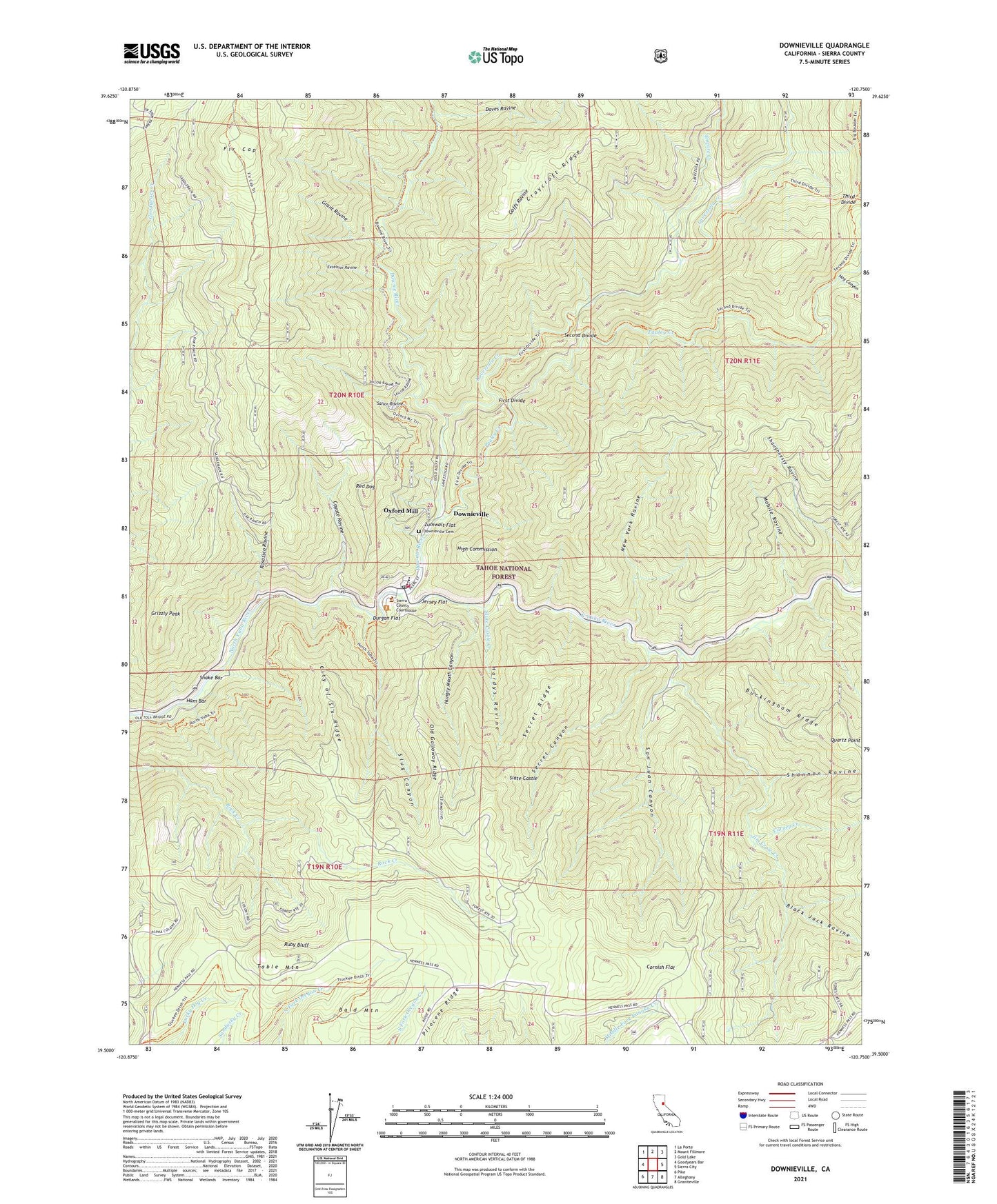
Downieville California US Topo Map
Couldn't load pickup availability
Also explore the Downieville Forest Service Topo of this same quad for updated USFS data
2021 topographic map quadrangle Downieville in the state of California. Scale: 1:24000. Based on the newly updated USGS 7.5' US Topo map series, this map is in the following counties: Sierra. The map contains contour data, water features, and other items you are used to seeing on USGS maps, but also has updated roads and other features. This is the next generation of topographic maps. Printed on high-quality waterproof paper with UV fade-resistant inks.
Quads adjacent to this one:
West: Goodyears Bar
Northwest: La Porte
North: Mount Fillmore
Northeast: Gold Lake
East: Sierra City
Southeast: Graniteville
South: Alleghany
Southwest: Pike
This map covers the same area as the classic USGS quad with code o39120e7.
Contains the following named places: Alpha Mine, Arizona Mine, Bald Mountain, Black Jack Ravine, Buckingham Ridge, Cannon Point Campground, Carney Creek, Carson Mine, City of Six Mine, City of Six Ridge, Comet Mine, Cooper Ranch, Cornish Flat, Cornish House, Cornish House Campsite, Coyote Ravine, Craycroft Diggings, Daves Ravine, Dolan Mine, Downie River, Downie River Trail, Downieville, Downieville Cemetery, Downieville Census Designated Place, Downieville Elementary School, Downieville Fire Protection District, Downieville Guard Station, Downieville Post Office, Durgan Flat, Empire Creek, Empire Ranch, Excelsior Mine, Excelsior Ravine, Fir Cap, First Divide, Galloway Ranch, Goffs Ravine, Gold Bluff Mine, Golden Bear Mine, Golden Hub Mine, Grant Ravine, Grizzly Peak, Ham Bar, Hardys Ravine, High Commission, Hog Canyon, Hungry Mouth Canyon, Ironsides Mine, Isabel Placer Mine, Jersey Flat, Jim Crow Creek, Lavezzola Creek, Lavezzola Ranch, Magnolia Mine, Mexican Mine, Middaugh Cabin, Mobile Ravine, Monte Cristo, Monte Cristo Mine, Mott Mine, Mount Vernon, Mount Vernon Mine, New York Ravine, Oak Ranch, Old Galloway Ridge, Oro Mine, Oxford Mill, Oxford Mine, Papoose Creek, Pauley Creek, Pliocene Mine, Pliocene Ridge, Quartz Point, Red Ant, Red Dog, Rosassco Ravine, Ruby Bluff, Ruby Mine, Sailor Ravine, San Juan Canyon, Second Divide, Second Divide Trail, Secret Canyon, Secret Ridge, Shannon Ravine, Shasta Mine, Shaughnessy Ravine, Sierra County Courthouse, Sierra County Sheriffs Gallows, Slate Castle, Slate Castle Creek, Slug Canyon, Snake Bar, Standard Mine, Table Mountain, Telegraph Mine, Third Divide, Third Divide Trail, Triple Pocket Mine, West Sierra Division, White Bear Mine, Winrod Mine, Zumwalt Flat, ZIP Code: 95936