MyTopo
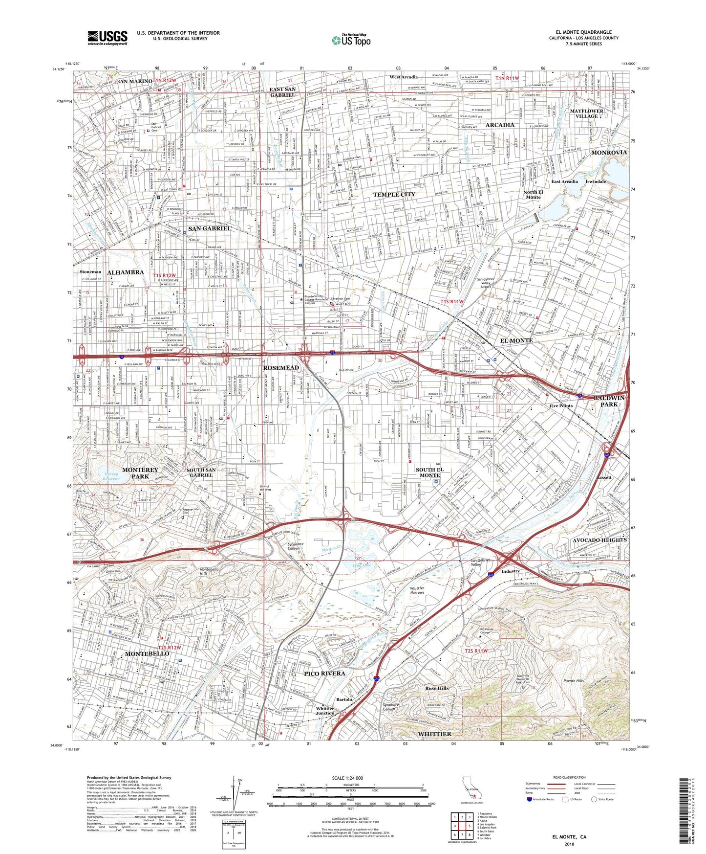
El Monte California US Topo Map
Couldn't load pickup availability
2022 topographic map quadrangle El Monte in the state of California. Scale: 1:24000. Based on the newly updated USGS 7.5' US Topo map series, this map is in the following counties: Los Angeles. The map contains contour data, water features, and other items you are used to seeing on USGS maps, but also has updated roads and other features. This is the next generation of topographic maps. Printed on high-quality waterproof paper with UV fade-resistant inks.
Quads adjacent to this one:
West: Los Angeles
Northwest: Pasadena
North: Mount Wilson
Northeast: Azusa
East: Baldwin Park
Southeast: La Habra
South: Whittier
Southwest: South Gate
This map covers the same area as the classic USGS quad with code o34118a1.
Contains the following named places: Acuna Park, Alhambra Airport, Alhambra Clinic, Alhambra Valley Shopping Center, Alhambra Wash, Almansor Municipal Golf Course, Almansor Park, Annunciation School, Arcadia Christian School, Arcadia Golf Course, Arcadia Wash, Arceo Park, Arroyo High School, Avocado Creek, B F Maxson Elementary School, Baldwin Stocker Elementary School, Baldwin Stocker Park, Bartolo, Beaches Shopping Center, Beverly Hospital, BHC Alhambra Hospital, Bicentennial Park, Buddhist Tzu Chi Free Clinic, California Country Club, Camino Grove Park, Camino Grove School, Charles T Kranz Intermediate School, Cherrylee Elementary School, City of El Monte, City of Montebello, City of Rosemead, City of San Gabriel, City of San Marino, City of South El Monte, City of Temple City, Clayton, Cleminson Elementary School, Cloverly Elementary School, Columbia Elementary School, Community Center Park, Coolidge Elementary School, Cortada Elementary School, Crawfords Shopping Center, Don Bosco Technical Institute, Durfee Elementary School, East Arcadia, East San Gabriel, East San Gabriel Census Designated Place, Eaton Wash, Edwards Drive-In, El Monte, El Monte High School, El Monte Medical Center, El Monte Shopping Center, Elm Center Shopping Center, Emmaus Lutheran School, Emperor Elementary School, Encinita Elementary School, Epiphany School, Five Points, Five Points Plaza Shopping Center, Fletcher Park, Fremont Elementary School, Garfield Medical Center, Garvey 35-006 Dam, Garvey Park, Garvey Ranch Park, Garvey Reservoir, Garvey Square Shopping Center, George I Sanchez Elementary School, Gidley Elementary School, Granada Elementary School, Grandview Sanitarium, Grant Rea Park, Greater El Monte Community Hospital, Hayes, Hillcrest Elementary School, Huerto de Cuati, Huntington Intermediate School, Jefferson Intermediate School, Jenny T Baker Elementary Shcool, Jerry Voorhis Elementary School, Jess Gonzales Sports Park, John Marshall Elementary School, Joslyn Adult Recreation Center, KALI-AM (San Gabriel), Keenan School, Kenosha Spur, Klingerman Park, La Loma Park, La Merced, La Merced Elementary School, La Primaria Elementary School, La Rosa Elementary School, Lacy Park, Lambert Park, Legg Lake, LeGore Elementary School, Lincoln School, Lindaraka Park, Live Oak Park, Longden Avenue Park, Longden Elementary School, Longley Way Elementary School, Los Angeles Downtown Medical Center - Ingleside Campus, Lutheran School, Macy Intermediate School, Madison Elementary School, Margaret Duff Elementary School, Mark Keppel High School, Martha Baldwin Elementary School, Mary Van Dyke Park, Maxson, Mayflower Village, Mayflower Village Census Designated Place, McKinley Elementary School, Mildred B Janson Elementary School, Mission Creek, Mission of San Gabriel, Monte Vista Elementary School, Montebello, Montebello Convalescent Hospital, Montebello Gardens Elementary School, Montebello High School, Montebello Hills, Montebello Mart Shopping Center, Montebello Park, Montebello Plaza Shopping Center, Montebello Town Center Shopping Center, Montebello Town Square Shopping Center, Monterey Park, Monterey Sanitarium, Mountain View Park, New Temple Park, Nike Site LA-14C, Nike Site LA-14L, North El Monte, North El Monte Census Designated Place, P F Cogswell Elementary School, Peck Road Park, Pellissier Spur, Pico Park, Pico Rivera Bicentennial Park, Pico Rivera Plaza Shopping Center, Pioneer Park, Potrero Chico, Potrero de Filipe Lugo, Potrero Grande, Potrero Heights Park, Puente Hills Landfill, Ralph Waldo Emerson Elementary School, Ramona Park, Reggie Rodriguez Park, Resurrection Cemetery, Richard Henry Dana Middle School, Rio Hondo Park, Rod Marinelli Stadium, Rose Hills Census Designated Place, Rose Hills Memorial Park - Cemetery, Rosemead, Rosemead Airport, Rosemead Park, Rosemead Square Shopping Center, Rubio Wash, Sally Tanner Park, San Angelo Park, San Francisquito, San Gabriel, San Gabriel Cemetery, San Gabriel Country Club, San Gabriel Mission High School, San Gabriel Valley, San Gabriel Valley Airport, San Gabriel Valley Hospital, San Gabriel Valley Medical Center, San Jose Creek, San Jose Creek Diversion Channel, San Jose Creek Water Reclamation Plant, San Marino, Santa Anita Park, Santa Anita Sanitarium, Santa Anita Wash, Savannah, Savannah Memorial Park, Sawpit Wash, SCE Headquarters Heliport, SCE Rosemead Heliport, Shepherd Field, Shiveley Park, Sibagna, Sierra Vista Park, Site of Mission Vieja Station, Smith Park, South El Monte, South San Gabriel, South San Gabriel Census Designated Place, Southwest San Gabriel Valley Division, Stoneman, Story Park, Streamland Park, Sycamore Canyon, Temple City, Temple City Park, Temple City Square Shopping Center, Tierra Verde Park, Tract of Land Near San Gabriel, Tracts of Land Near San Gabriel, Twin Lakes Golf Course, Universal Square Shopping Center, Upper San Gabriel Valley Division, Vincent Lugo Park, Walnut Creek, Wells Fargo-El Monte Heliport, Whittier Junction, Whittier Narrows, Whittier Narrows Dam, Whittier Narrows Dam County Recreational Are, Whittier Narrows Golf Course, Whittier Narrows Nature Center, Whittier Narrows Reservoir, Whittier Narrows Water Reclamation Plant, Wilmar, Zamora Park, Zapopan Park, ZIP Codes: 90601, 90640, 91108, 91731, 91732, 91733, 91755, 91770, 91775, 91776, 91780


