MyTopo
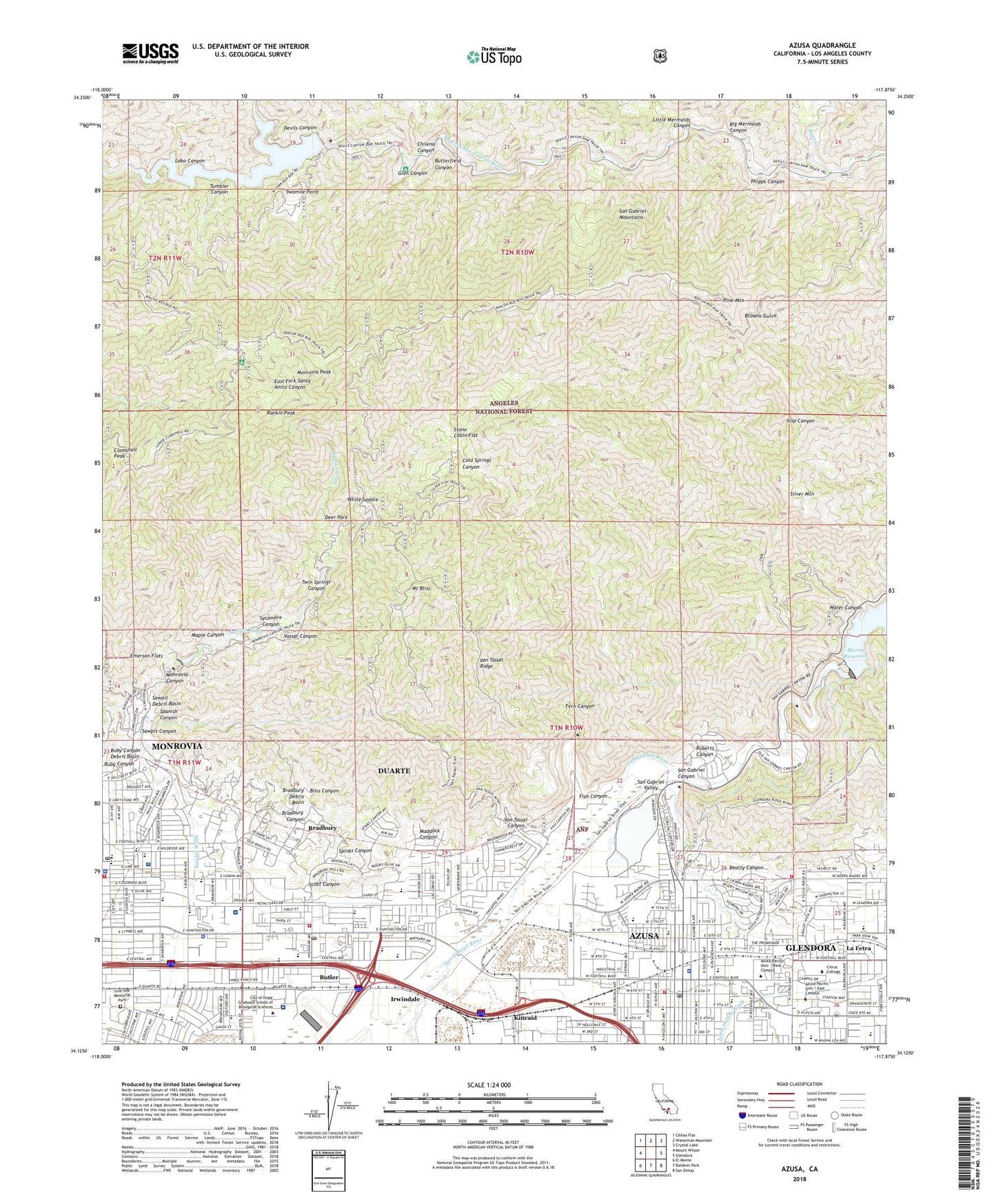
Azusa California US Topo Map
Couldn't load pickup availability
Also explore the Azusa Forest Service Topo of this same quad for updated USFS data
2021 topographic map quadrangle Azusa in the state of California. Scale: 1:24000. Based on the newly updated USGS 7.5' US Topo map series, this map is in the following counties: Los Angeles. The map contains contour data, water features, and other items you are used to seeing on USGS maps, but also has updated roads and other features. This is the next generation of topographic maps. Printed on high-quality waterproof paper with UV fade-resistant inks.
Quads adjacent to this one:
West: Mount Wilson
Northwest: Chilao Flat
North: Waterman Mountain
Northeast: Crystal Lake
East: Glendora
Southeast: San Dimas
South: Baldwin Park
Southwest: El Monte
This map covers the same area as the classic USGS quad with code o34117b8.
Contains the following named places: Adams Field, Adams Hall, Aloysia Moore Park, Andres Duarte Elementary School, Antioch Church, Azusa, Azusa City Hall, Azusa City Library, Azusa City Park, Azusa Greens Public Golf Course, Azusa High School, Azusa Pacific University, Azusa Police Department, Azusa Post Office, Azusa Square Shopping Center, Bear Creek, Beardslee Elementary School, Beardslee Park, Beatty Canyon, Bethlehem Temple Apostolic Church, Big Mermaids Canyon, Bliss Canyon, Bradbury, Bradbury Canyon, Bradbury City Hall, Bradbury Debris Basin, Bradoaks Elementary School, Brown Military Academy, Butler, Butterfield Canyon, Camp Aventura, Canyon High School, Canyon Tuberculosis Preventatorium, Catechetical Center, Charles H Lee Elementary School, Chileno Canyon, Chinese Alliance Bible Church, Christian School, Church of Christ, Church of Jesus Christ of Latter Day Saints, Church of the Foothills, Church of the Nazarene, Citrus College, Citrus Laboratory School, Citrus Union High School, City of Azusa, City of Bradbury, City of Duarte, City of Hope Graduate School of Biological Science, City of Hope Medical Center, City of Monrovia, City of Monrovia Fire Department Station 101 Headquarters, Clamshell Peak, Clifton Middle School, Cloverleaf Canyon, Cogswell 32-005 Dam, Cogswell Dam, Cogswell Reservoir, Cold Springs Canyon, College Center Shopping Center, Cougar Mall, Deer Park, Devils Canyon, Duarte, Duarte Branch County of Los Angeles Public Library, Duarte City Hall, Duarte High School, Duarte Park, Duarte Post Office, Duarte Sports Park, Ellen School, Emerson Flats, Emmanuel Baptist Church, Encanto Park, Engstrom Hall, Fern Canyon, First Assembly of God Church, First Baptist Church, First Presbyterian Church, Fish Canyon, Foothill Center Shopping Center, Girls Collegiate School, Glen Campground, Glen Canyon, Gordon Sports Park, Grand Avenue Park, Greater Ambassador Church of God, Hacienda Park, Handy Campus Center, Hartwig Prayer Chapel, Haugh Performing Arts Center, Hayden Hall, Hayden Library, Henry Dalton Elementary School, Hodge Elementary School, Immaculate Conception Church, Immaculate Conception School, Indonesian Evangelical Church, Irwindale Raceway, Julian Fisher Park, Kincaid, Kingdom Hall of Jehovahs Witnesses, La Fetra, La Rew School, Las Lomas, Little Mermaids Canyon, Live Oak Memorial Park, Lobo Canyon, Longfellow Elementary School, Los Angeles County Fire Department Station 32, Los Angeles County Fire Department Station 44, Los Angeles County Fire Department Station 97, Los Angeles County Sheriff's Department - Duarte Satellite Office, Maddock Canyon, Manresa Retreat, Maple Canyon, Maryknoll Hospital, Maxwell Elementary School, Memorial Park, Monarc Ambulance, Monrovia, Monrovia Airport, Monrovia Canyon, Monrovia City Hall, Monrovia Community Hospital, Monrovia Memorial Hospital, Monrovia Mountain Park, Monrovia Peak, Monrovia Police Department, Monrovia Post Office, Morris 35-005 Dam, Morris Dam, Mount Bliss, Mount Sierra College, Mountain Vista Plaza Shopping Center, Munson Chapel, New Beginnings Baptist Church, Northside Park, Northview Intermediate School, Northview Park, Oak Park, Open Door Church of God in Christ, Pasadena Bait Club, Phipps Canyon, Pine Mountain, Pioneer Park, Rainbow Club, Rancho Duarte Golf Course, Rankin Peak, Recreation Park, Roberts Canyon, Ronald Center, Royal Oaks Elementary School, Royal Oaks Park, Ruby Canyon, Ruby Canyon Debris Basin, Saint Frances of Rome School, Saint Francis of Rome Church, Saint Lucys Priory School, Saint Luke's Episcopal Church, San Gabriel Canyon, San Gabriel Valley Gun Club, Sandburg Middle School, Santa Teresita Hospital, Sawpit 32-012 Dam, Sawpit Canyon, Sawpit Dam, Sawpit Debris Basin, Sawpit Debris Dam, Scott Canyon, Scott School, Second Baptist Church, Seven Palms Amphitheater, Sierra Military Academy, Silver Mountain, Slauson Middle School, Slauson Park, Smith Hall, South Pasadena Veterans Camp, Spanish Canyon, Spinks Canyon, Spring Camp, Stanton Elementary School, Stone Cabin, Stone Cabin Flat, Sycamore Canyon, Third Street Park, Tool Cabin, Trinity Hall, Tumbler Canyon, Tumbler Target Shooting Area, Turner Campus Center, Twin Springs Canyon, Twomile Point, Valley Community Church of Peace, Valley View Elementary School, Valley View Park, Van Tassel Canyon, Van Tassel Ridge, Vassar Canyon, W R Powell Elementary School, Warren Music Center, Water Canyon, West Gymnasium, Westminster Gardens, White Saddle, Wild Rose Elementary School, Wilden Hall, Wildwood Rancho, William V Marshburn Memorial Library, Wynn Science Center, ZIP Codes: 91008, 91010