MyTopo
Laguna Beach California US Topo Map
Couldn't load pickup availability
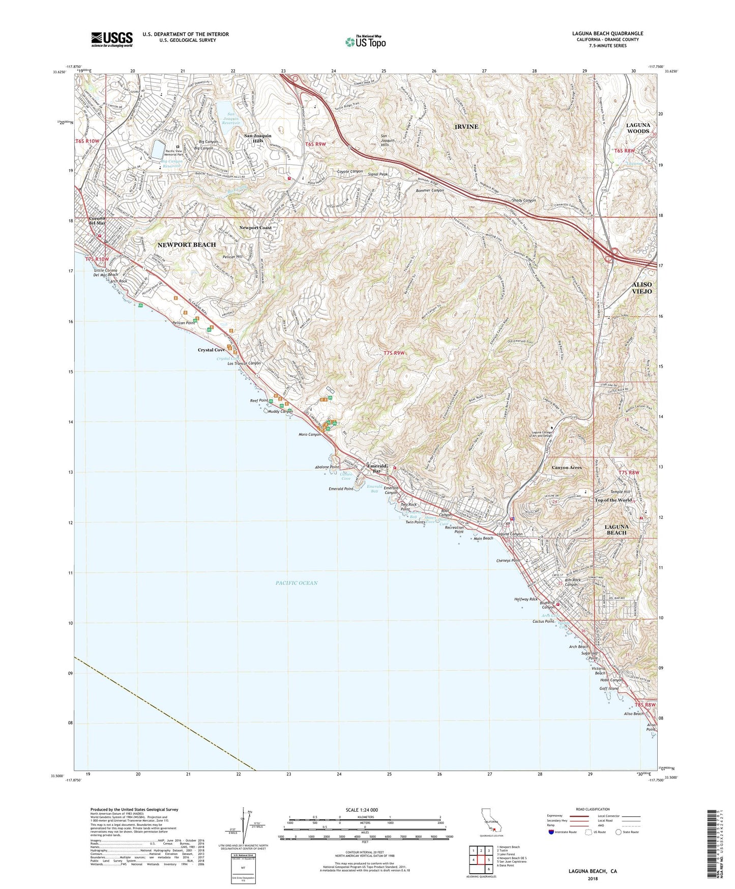
2022 topographic map quadrangle Laguna Beach in the state of California. Scale: 1:24000. Based on the newly updated USGS 7.5' US Topo map series, this map is in the following counties: Orange. The map contains contour data, water features, and other items you are used to seeing on USGS maps, but also has updated roads and other features. This is the next generation of topographic maps. Printed on high-quality waterproof paper with UV fade-resistant inks.
Quads adjacent to this one:
West: Newport Beach OE S
Northwest: Newport Beach
North: Tustin
Northeast: Lake Forest
East: San Juan Capistrano
Southeast: Dana Point
This map covers the same area as the classic USGS quad with code o33117e7.
Contains the following named places: Abalone Point, Aliso Beach, Aliso Beach County Park, Aliso Creek, Aliso Pier, Aliso Point, Aliso School, Alito Park, Alta Laguna Park, Andersen Elementary School, Arch Beach, Arch Cove, Arch Rock, Art Institute of Southern California, Big Canyon 1058 Dam, Big Canyon Reservoir, Bluebird Canyon, Bluebird Park, Boat Canyon, Boat Canyon Park, Boat Canyon Shopping Center, Buck Gully, Buffalo Hills Park, Cactus Point, Calvary Evangelical Free Church, Cameo Cove, Canyon Acres, Cathedral Chapel of Saint Francis By-The Sea, Cheneys Point, City of Laguna Beach, Corona del Mar, Corona del Mar Branch Newport Beach Public Library, Corona del Mar Post Office, Corona Del Mar School, Crescent Bay, Crescent Bay Point Park, Crystal Cove, Crystal Cove Historic District, Crystal Cove State Park, Divers Cove, El Morro Beach Trailer Park, El Morro Elementary School, Emerald Bay, Emerald Canyon, Emerald Point, Festival of the Arts Amphitheater, First Church of Christ Scientist, Goff Island, Grant Howald Park, Halfway Rock, Harbor School, Harbor View 1012-002 Dam, Harbor View Elementary School, Harbor View Nature Park, Harbor View Shopping Center, Heisler Park, Hobo Canyon, Irvine Bowl Park, Irvine Coast Marine Life Refuge, Jahraus Park, Jasmine View Park, Laguna Beach, Laguna Beach Branch Orange County Public Library, Laguna Beach City Hall, Laguna Beach Fire Department Station 1, Laguna Beach Fire Department Station 2, Laguna Beach Fire Department Station 3, Laguna Beach High School, Laguna Beach Marine Life Refuge, Laguna Beach Police Department, Laguna Beach United Methodist Church, Laguna Canyon, Laguna College of Art and Design, Laguna Museum of Art, Laguna Presbyterian Church, Laguna Terace Mobile Home Park, Lagunas, Lang Park, Lincoln Elementary School, Little Corona Del Mar Beach, Los Trancos Canyon, Lumberyard Plaza Shopping Center, Main Beach, Main Beach Park, Moro Canyon, Moulton Meadows Park, Muddy Canyon, Newport Beach Fire Department Station 5, Newport Beach Fire Department Station 8, Newport Coast, Newport Coast Census Designated Place, Nita Carman Park, Old School Park, Orange County Fire Authority Station 11, Pacific View Memorial Park, Pelican Hill, Pelican Hill Golf Club, Pelican Point, Playa Post Office, Recreation Point, Reef Point, Rim Rock Canyon, Ruby Street Park, Saint Catherine Catholic Church, Saint Catherine of Siena School, Saint Marys Episcopal Church, San Joaquin Hills, San Joaquin Hills Census Designated Place, San Joaquin Reservoir, San Joaquin Reservoir 1029 Dam, San Miguel Park, Shaws Cove, Sherman Gardens, Signal Peak, Spyglass Hill Park, Sugarloaf Point, Swanson Park, Temple Hill, The Church of Jesus Christ of Latter Day Saints, The Pavilions Shopping Center, Thurston Middle School, Top of the World, Top of the World Elementary School, Treasure Island Mobile Home Park, Twin Points, Two Rock Point, Victoria Beach, Woods Cove, ZIP Codes: 92603, 92625, 92651, 92657