MyTopo
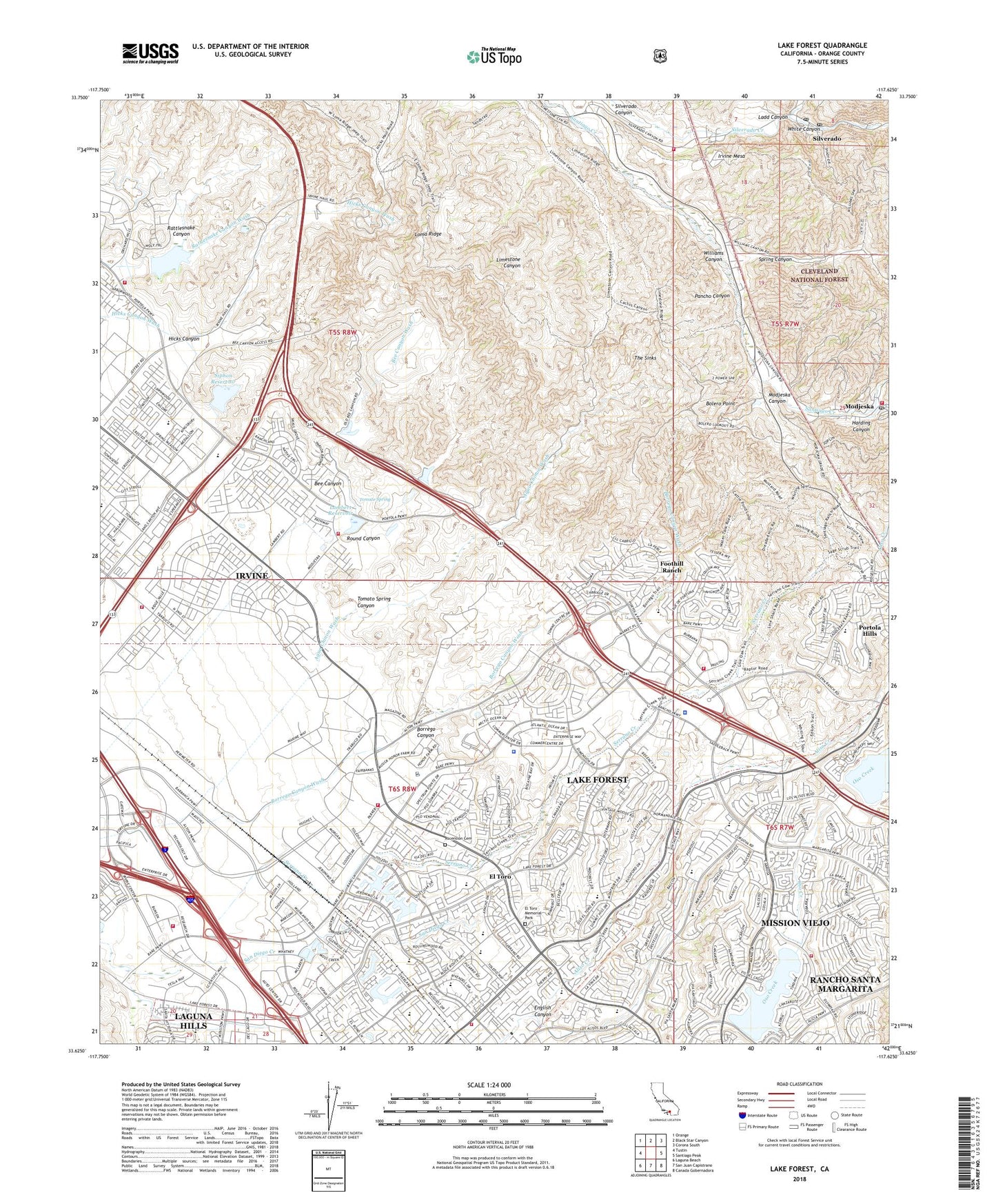
Lake Forest California US Topo Map
Couldn't load pickup availability
Also explore the Lake Forest Forest Service Topo of this same quad for updated USFS data
2022 topographic map quadrangle Lake Forest in the state of California. Scale: 1:24000. Based on the newly updated USGS 7.5' US Topo map series, this map is in the following counties: Orange. The map contains contour data, water features, and other items you are used to seeing on USGS maps, but also has updated roads and other features. This is the next generation of topographic maps. Printed on high-quality waterproof paper with UV fade-resistant inks.
Quads adjacent to this one:
West: Tustin
Northwest: Orange
North: Black Star Canyon
Northeast: Corona South
East: Santiago Peak
Southeast: Canada Gobernadora
South: San Juan Capistrano
Southwest: Laguna Beach
Contains the following named places: Aliso Elementary School, Ascension Cemetery, Barcelona Hills Elementary School, Barcelona Park, Bee Canyon, Bolero Lookout, Bolero Point, Borrego Canyon, Borrego Canyon Wash, Canada De Los Alisos, City of Lake Forest, County Industrial Farm, Crucero Park, Del Lago Elementary School, Doctor's Ambulance Service, El Toro, El Toro Game Bird Club, El Toro High School, El Toro Marine School, El Toro Memorial Park, El Toro Pit, English Canyon, Flamenco Park, Foothill Ranch, Foothill Ranch Census Designated Place, Harding Canyon, Heritage Hill Historical Park, Hicks Canyon, International Raceway, Irvine Mesa, Irvine-Lake Forest Division, James H Musick Branch Jail, La Madera Elementary School, Ladd Canyon, Lake Forest, Lake Forest Park, Lake Forest Police Department, Lake Forest Village Shopping Center, Lake Mission Viejo, Lake Mission Viejo 1794 Dam, Lambert 793 Dam, Lambert Reservoir, Loma Ridge, Marine Corps Air Station El Toro, Marine Memorial Golf Course, Market on the Lake Shopping Center, Melinda Park, Minaya Park, Mission Viejo Youth Athletic Park, Modjeska, Modjeska Canyon, Modjeska Canyon Post Office, Modjeska Census Designated Place, Mountain View Park, Orange County Fire Authority Station 15, Orange County Fire Authority Station 16, Orange County Fire Authority Station 19, Orange County Fire Authority Station 20, Orange County Fire Authority Station 27, Orange County Fire Authority Station 31, Orange County Fire Authority Station 38, Orange County Fire Authority Station 51, Orange County Fire Authority Station 54, Orange County Fire Authority Station 55, Pacific Ambulance, Pancho Canyon, Pebble Creek Park, Portola Hills, Portola Hills Census Designated Place, Ranchwood Park, Rattlesnake Canyon, Rattlesnake Canyon 1029-003 Dam, Rattlesnake Reservoir, Rimgate Park, Round Canyon, Santiago Canyon, Santiago Elementary School, SCE El Toro Heliport, SCE Saddleback Service Center Heliport, Serrano Creek, Serrano Creek Community Park, Serrano Intermediate School, Serrano Place, Seville Park, Silverado, Silverado Branch Orange County Public Library, Silverado Census Designated Place, Silverado Elementary School, Silverado Post Office, Silverado Station, Siphon Reservoir, South Coast Agriculture Field Station, Spring Canyon, Syphon Canyon 793-009 Dam, The Sinks, Tomato Spring, Tomato Spring Canyon, Upper Oso Dam, Upper Oso Reservoir, Veeh 796 Dam, Veeh Ranch Park, Vista del Lago Park, White Canyon, Whiting Ranch Wilderness Park, Wilderness Glen Park, Williams Canyon, Williams Canyon Census Designated Place, ZIP Codes: 92610, 92618, 92620, 92630