MyTopo
Lodi North California US Topo Map
Couldn't load pickup availability
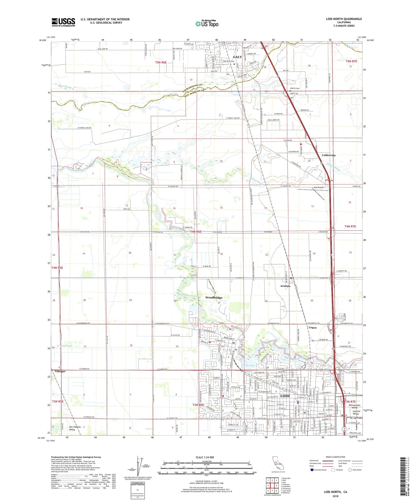
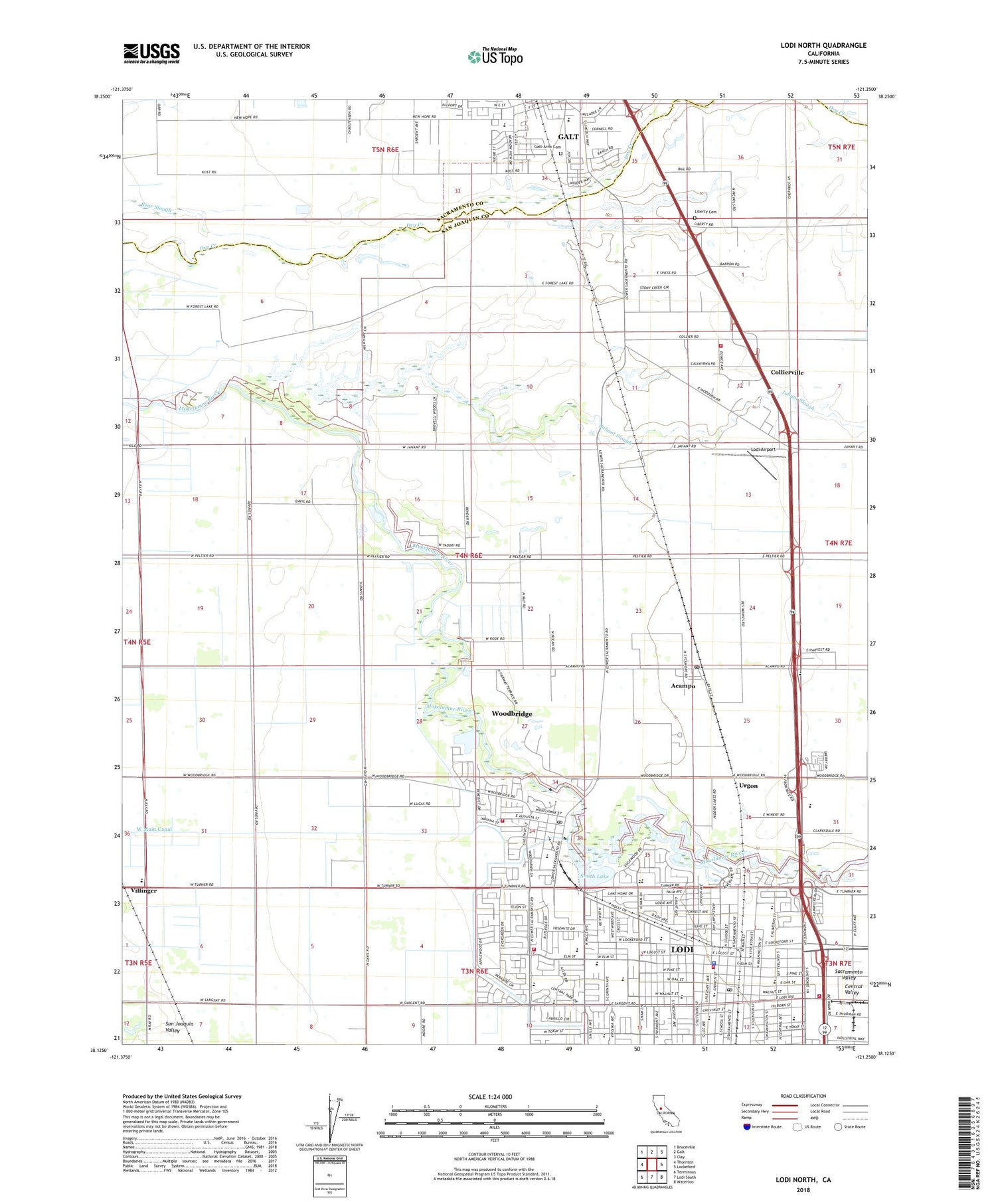
2021 topographic map quadrangle Lodi North in the state of California. Scale: 1:24000. Based on the newly updated USGS 7.5' US Topo map series, this map is in the following counties: San Joaquin, Sacramento. The map contains contour data, water features, and other items you are used to seeing on USGS maps, but also has updated roads and other features. This is the next generation of topographic maps. Printed on high-quality waterproof paper with UV fade-resistant inks.
Quads adjacent to this one:
West: Thornton
Northwest: Bruceville
North: Galt
Northeast: Clay
East: Lockeford
Southeast: Waterloo
South: Lodi South
Southwest: Terminous
This map covers the same area as the classic USGS quad with code o38121b3.
Contains the following named places: Acampo, Acampo Census Designated Place, Acampo Post Office, Bethel Open Bible Church, Calvary Bible Church, Carnegie Library, Central Seventh Day Adventist Church, Childrens Center, Church of Christ, Church of God, Church of the Nazarene, Collierville, Collierville Census Designated Place, Community Hospital, Dry Creek Ranch Golf Course, Emanuel American Lutheran Church, Emerson Park, Erma B Reese Elementary School, Fairmont Plaza Shopping Center, First Assembly of God Church, First Baptist Church, First Church of Christ Scientist, First Methodist Church, First Pentecostal Church of Lodi, Forest Lake, Forest Lake Golf Course, Galt Cemetery, George Washington Elementary School, Grape Festival Buildings, Hale Park, Heritage Elementary School, Hilborn Seventh Day Adventist Church, Houston School, Jahant Slough, KCVR-AM (Lodi), Lakewood Elementary School, Lakewood Mall Shopping Center, Lawrence Elementary School, Lawrence Park, Liberty Cemetery, Liberty High School, Liberty School, Lodi, Lodi Adult School, Lodi Airport, Lodi Avenue Baptist Church, Lodi Chamber of Commerce, Lodi City Hall, Lodi Division, Lodi Fire Department Station 1, Lodi Fire Department Station 2, Lodi Fire Department Station 4, Lodi High School, Lodi Industrial Park, Lodi Lake Park, Lodi Lake Wilderness Area, Lodi Municipal Lake Park, Lodi Police Department, Lodi Post Office, Lodi Stadium, Lodi Womens Club, Maple Square, Mattison Hall, Meadow View Park, Mediplane - Reach II, Mennonite Brethren Church, Needham School, North Ridge Industrial Center, North Woodbridge Census Designated Place, Oliver Lake, Palmer Farms, Ray School, Revival Center, Saint Anne School, Saint Annes Roman Catholic Church, Saint John the Baptist Episcopal Church, Saint Peter Lutheran School, Saint Peters Lutheran Church, Saint Peters School, Salem Evangelical Church, San Joaquin County Sheriff's Office Lodi, Smith Lake, South Woodbridge Census Designated Place, Temple Baptist Church, Tracy Lake, Turner Elementary School, Twin Oaks Park, Urgon, Van Buskirk Park, Villinger, Vinewood Elementary School, Washington Development Center, West Main Canal, Westgate Park, Woodbridge, Woodbridge Census Designated Place, Woodbridge Country Club, Woodbridge Diversion 71-000 Dam, Woodbridge Fire Protection District Station 1, Woodbridge Fire Protection District Station 3, Woodbridge Masonic Cemetery, Woodbridge Middle School, Woodbridge Post Office, Woodbridge Regional Park, Zupo Field, ZIP Code: 95258