MyTopo
Los Alamitos California US Topo Map
Couldn't load pickup availability
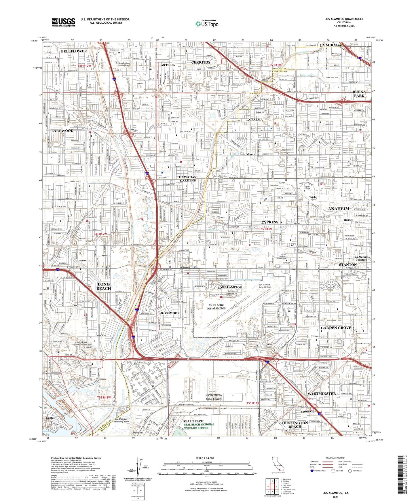
2023 topographic map quadrangle Los Alamitos in the state of California. Scale: 1:24000. Based on the newly updated USGS 7.5' US Topo map series, this map is in the following counties: Orange, Los Angeles. The map contains contour data, water features, and other items you are used to seeing on USGS maps, but also has updated roads and other features. This is the next generation of topographic maps. Printed on high-quality waterproof paper with UV fade-resistant inks.
Quads adjacent to this one:
West: Long Beach
Northwest: South Gate
North: Whittier
Northeast: La Habra
East: Anaheim
Southeast: Newport Beach
South: Seal Beach
Southwest: Long Beach OE S
This map covers the same area as the classic USGS quad with code o33118g1.
Contains the following named places: Aloha Health Medical Academy, Anaheim General Hospital, Arlington College, Artesia, Artesia Cemetery, Artesia Christian School, Artesia High School, Artesia Park, Artesia Town Center Shopping Center, Barber City, Beat Park, Bellis Park, Best Plaza Shopping Center, Bettencourt Park, Bingham, Bixby Ranch, Bixby School, Bixby Village Golf Course, Bloomfield Park, Bloomfield School, Bolsa Chica Park, Boos Elementary School, Boyar Park, Brenner Park, Brookhaven Park, Buckingham Park, Buena Park Junior High School, Buena Terra Elementary School, Burbank Elementary School, Cabrillo Lane School, California State University Long Beach, Calvary Chapel Christian School Cypress, Candleverde Park, Carbon Creek, Carl E Gilbert Elementary School, Carwood Shopping Center, Cedar Glen Park, Central Park, Centralia Elementary School, Cerritos, Cerritos Auto Square, Cerritos Elementary School, Cerritos Plaza Shopping Center, Cerritos Regional County Park, Cerritos South Town and Country Shopping Center, Cerritos Towne Center Shopping Center, Channel View Park, Chapman Sports Park, Charles Damron Elementary School, City of Artesia, City of Buena Park, City of Cerritos, City of Cypress, City of Hawaiian Gardens, City of La Palma, City of Lakewood, City of Los Alamitos, City of Seal Beach, Clarkdale Park, Cleveland Elementary School, Clifton School, College Park, Cook School, Coyote Creek, Cubberley K - 8 School, Cypress, Cypress College, Cypress Golf Club, Cypress Park, Cypress Plaza East Shopping Center, Cypress Plaza Shopping Center, Cypress Square Shopping Center, Danbrook Elementary School, Darrell Essex Park, David Burcham K - 5 School, Davies Bridge, De Mille Middle School, Dolley, Eastgate Park, Eastgate Plaza Shopping Center, Eastwood Elementary School, Edgar Park, Edgar School, Edison Park, El Dorado Park, El Dorado Park Golf Course, El Rancho Verde Park, Elizabeth Dickerson Elementary School, Elliott Elementary School, Emerson Parkside Academy, Enders Elementary School, Eucalyptus Park, Finley Elementary School, Forest Lawn Memorial Park - Cypress, Franklin Park, Friendship Park, Fullerton Creek, Gahr High School, Gant Elementary School, Garden Park School, Gardens Regional Hospital and Medical Center, Golden West Park, Gridley Park, Gummere Park, Halcon, Hansen, Hansen Elementary School, Hansen Park, Haskell STEM Academy, Hawaiian Elementary School, Hawaiian Gardens, Hawaiian Gardens Square Shopping Center, Heartwell Golf Course, Heartwell Park, Heather Park, Helen Keller School, Heritage Park, Horse Farm Naval Outer Landing Field, Indian Village Park, Jacob Street Park, John Douglas French Center for Alzheimers Disease, John Ford Stadium, Jose del Valle Park, Jose San Martin Park, KBPK-FM (Buena Park), La Canada Verde Creek, La Palma, La Palma Intercommunity Hospital, La Palma Shopping Center, Lakewood Equestrian Center, Lakewood Marketplace Shopping Center, Larwin Park, Laurel Park, Lee Ware Park, Leisure World, Leisure World Golf Course, Leisure World Shopping Center, Leylandi Park, Liberty Park, Lincoln Center Mobile Home Park, Lincoln Station Shopping Center, Little Cottonwood Park, Loma Park, Long Beach Marina, Long Beach Water Reclamation Plant, Long Beach Yacht Club, Los Alamitos, Los Alamitos Army Airfield, Los Alamitos Channel, Los Alamitos Medical Center, Los Alamitos Naval Air Station, Los Alamitos Racetrack, Los Alamitos Reserve Center and Air Station, Los Alamitos Retarding Basin, Los Alisos Mobile Home Estates, Los Cerritos Shopping Center, Los Coyotes, Los Robles Mobile Home Park, Marina Pacifica, Marine Park, Marine Stadium, Montana Ranch, Monteverde Park, Moody, Moody Creek, Municipal Park, Naples, Naples Plaza, Naval Hospital Long Beach, Naval Hospital-Long Beach Heliport, Nexus Town Center Shopping Center, Nike Site LA-32C, Nike Site LA-32L, Oak Academy Park, Oak Knoll Park, Old Ranch Golf Course, Orange County Community Hospital, Orville R Lewis Park, Palm Park, Pat Nixon Park, Peppertree Park, Pinewood Park, Pioneer Artesia Shopping Center, Pioneer Hospital, Pioneer Park, R I Seal Beach Helistop B80, Rainbow Park, Robert C Cawthon Elementary School, Rockwell Facility Heliport, Rockwell International Seal Beach Heliport, Rossmoor, Rossmoor Census Designated Place, Rossmoor Park, Rossmoor Shopping Center, Rossmoor Storm Channel, Royal Oak Mobile Home Park, Rynerson Park, Saddleback Park, Samuel Gompers K - 8 School, San Antonio Park, San Marino Park, Sato Academy of Mathematics and Science, Seal Beach Naval Weapons Station, Shapell Park, Shirley, Siger Park, Stanton Storm Channel, Sunshine Park, The Market Place Shopping Center, Town Square Shopping Center, VA Medical Center Heliport, Veterans Affairs Medical Center Long Beach, Veterans Park, West Gate Park, Westgrove Park, Westminster, Westminster Shopping Center, Whaley Park, William Peak Park, Willow Park, Woodruff Communtiy Hospital, ZIP Codes: 90620, 90623, 90630, 90701, 90703, 90713, 90715, 90716, 90720, 90740, 90808, 90815, 90822, 92845