MyTopo
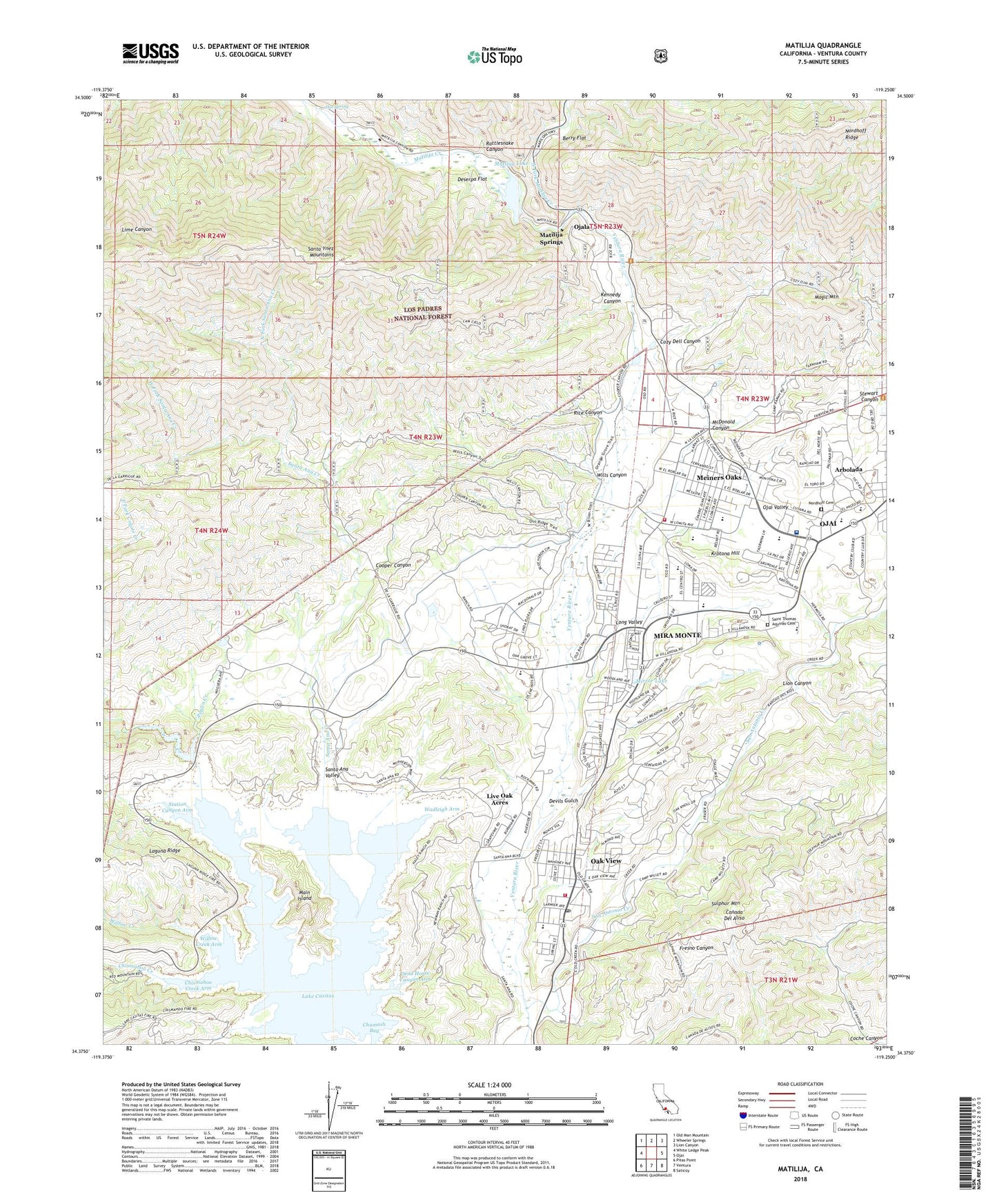
Matilija California US Topo Map
Couldn't load pickup availability
Also explore the Matilija Forest Service Topo of this same quad for updated USFS data
2022 topographic map quadrangle Matilija in the state of California. Scale: 1:24000. Based on the newly updated USGS 7.5' US Topo map series, this map is in the following counties: Ventura. The map contains contour data, water features, and other items you are used to seeing on USGS maps, but also has updated roads and other features. This is the next generation of topographic maps. Printed on high-quality waterproof paper with UV fade-resistant inks.
Quads adjacent to this one:
West: White Ledge Peak
Northwest: Old Man Mountain
North: Wheeler Springs
Northeast: Lion Canyon
East: Ojai
Southeast: Saticoy
South: Ventura
Southwest: Pitas Point
This map covers the same area as the classic USGS quad with code o34119d3.
Contains the following named places: Anola 762 Dam, Arbolada, Arnaz Elementary School, Berry Flat, Bible Baptist Church, Camp C, Camp Comfort, Camp Comfort Park, Camp D, Camp E, Camp F, Camp G, Camp H, Camp J, Camp K, Camp M, Camp O, Camp Ramah, Camp Romah, Camp W, Casita Municipal Water District Office, Casitas Dam, Casitas Fire Station, Casitas Forest Service Station, Casitas Saddle Dike Dam, Chismahoo Creek, Chismahoo Creek Arm, Chumash Bay, Church of the Living God, Cooper Canyon, Cozy Dell Canyon, Cozy Dell Trail, Dead Horse Canyon Arm, Del Francia Mobile Estates, Deserpa Flat, Devils Gulch, El Sereno Estates Mobile Home Park, Feraud Park, First Missionary Baptist Church, Friends Worship, Full Gospel Lighthouse Church, Golden Oaks Mobile Estates, Golden Oaks Mobile Home Park, Happy Valley School, Heritage Christian Academy, Hot Spring, Institute for Higher Education, Kennedy Canyon, Krotona Hill, Krotona Institute of Theosophy, Lake Casitas, Lake Casitas Recreation Area, Laurel Springs High School, Lifeline Medical Transport, Lion Canyon, Live Oak Acres, Long Valley, Magic Mountain, Main Island, Matilija, Matilija Creek, Matilija Dam, Matilija Junior High School, Matilija Lake, Matilija Springs, McDonald Canyon, Meiners Oaks, Meiners Oaks 768 Dam, Meiners Oaks Branch Ventura County Library, Meiners Oaks Census Designated Place, Meiners Oaks Elementary School, Meiners Oaks Trailer Park, Mira Monte, Mira Monte Census Designated Place, Mira Monte Elementary School, Mirror Lake, Nordhoff Cemetery, Nordhoff High School, North Fork Matilija Creek, North Fork Santa Ana Creek, Oak Grove School, Oak View, Oak View Branch Ventura County Library, Oak View Census Designated Place, Oak View Community Center, Oak View Elementary School, Oak View Post Office, Ojai Country Club, Ojai Presbyterian Church, Ojai Refuse Transfer Station, Ojai United Methodist Church, Ojai Valley, Ojai Valley Childrens House, Ojai Valley Community Hospital, Ojai Valley Estates Mobile Home Park, Ojai Valley Foursquare Church, Ojai Valley School, Ojai Valley Shopping Center, Ojala, Old Creek Ranch Winery, Oma Ojai Ranch, Poplin Creek, Pratt Trail, Rancho Matilija, Rattlesnake Canyon, Rice Canyon, Saint Andrews Episcopal Church, Saint Thomas Aquinas Cemetery, San Antonio Creek, Santa Ana, Santa Ana Creek, Santa Ana Valley, Science of Mind Church, Seventh Day Adventist Church, Sopers Ranch, Station Canyon Arm, Stewart Canyon Debris Dam, Stuart Canyon Picnic Ground, The Church of Jesus Christ of Latter Day Saints, Unitarian Universalist Fellowship of the Ojai Valley, Ventura County Fire Department Station 22, Ventura County Fire Protection District Station 23, Ventura County Honor Farm, Vickers Hot Springs, Villanova School, Wadleigh Arm, West Fork Santa Ana Creek, Willow Creek, Willow Creek Arm, Wills Canyon, ZIP Code: 93022