MyTopo
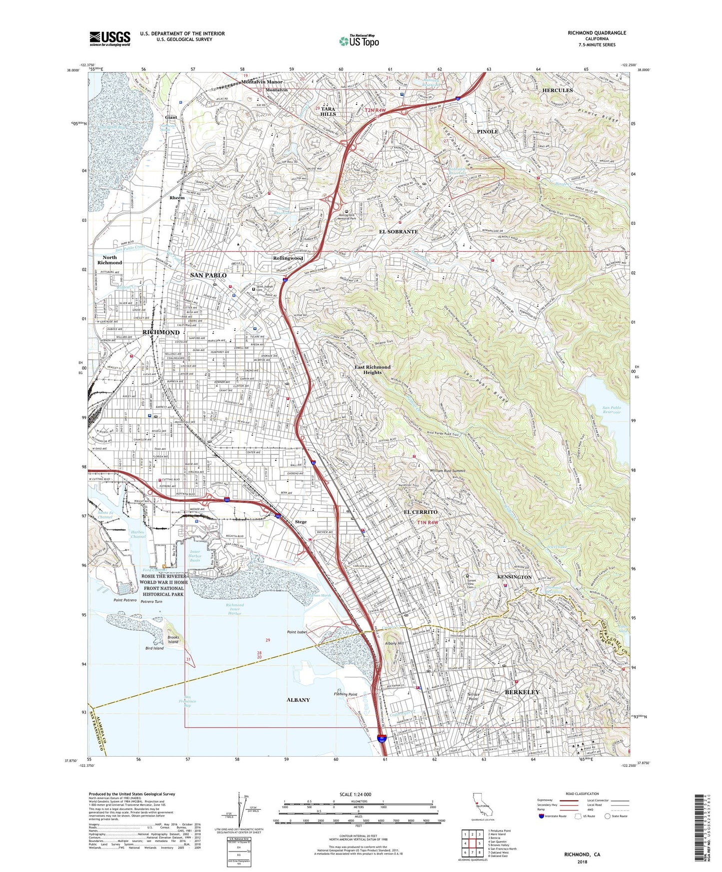
Richmond California US Topo Map
Couldn't load pickup availability
2021 topographic map quadrangle Richmond in the state of California. Scale: 1:24000. Based on the newly updated USGS 7.5' US Topo map series, this map is in the following counties: Contra Costa, Alameda, San Francisco. The map contains contour data, water features, and other items you are used to seeing on USGS maps, but also has updated roads and other features. This is the next generation of topographic maps. Printed on high-quality waterproof paper with UV fade-resistant inks.
Quads adjacent to this one:
West: San Quentin
Northwest: Petaluma Point
North: Mare Island
Northeast: Benicia
East: Briones Valley
Southeast: Oakland East
South: Oakland West
Southwest: San Francisco North
This map covers the same area as the classic USGS quad with code o37122h3.
Contains the following named places: Adams Middle School, Albany, Albany Cougar Athletic Field, Albany High School, Albany Hill, Albany Hill Park, Albany Hospital, Alvarado Park, Alvarado School, Appian Eighty Shopping Center, Argyle Number 2 31-030 Dam, Arlington Park, Atchison Village, Atchison Village Park, Balboa School, Barbara and Jay Vincent Park, Bayside Medical Group Pinole, Bayview Elementary School, Belding School, Berkeley Rose Garden, Berkely Reef, Berryman Reservoir, Berryman Reservoir 31-008 Dam, Berryman Station, Bird Island, Booker T Anderson Eastshore Park, Boorman Park, Broadway School, Brooks Island, Brooks Island Regional Shoreline, Brookside Hospital Heliport, Burg Park, C L Tilden Park 29-002 Dam, Camp Herms, Canyon Trail Park, Casa Cerrito Park, Casa Cerrito Recreation Center, Castro Elementary School, Castro Park, Central Park, Cerrito Creek, Cerrito Vista Park, Channel Marina, Christiana B Cameron Elementary School, City of Albany, City of El Cerrito, City of Richmond, City of San Pablo, Codornices Creek, Codornices Park, Contra Costa College, Corbin Station, Cornell Elementary School, Coronado Elementary School, Cortez School, Cragmont, Cragmont Elementary School, Cragmont Park, Creekside Park, Crescent Park, Crispi Middle School, De Anza Senior High School, Doctors Hospital, Doctors Medical Center San Pablo Campus, Dover Elementary School, East Bay Hospital, East Richmond, East Richmond Heights, East Richmond Heights Census Designated Place, Easter Hill Village, Edward M Downer Elementary School, El Cerrito, El Cerrito Community Swim Center, El Cerrito High School, El Cerrito Plaza Shopping Center, El Portal Elementary School, El Portal Shopping Center, El Sobrante, El Sobrante Census Designated Place, El Sobrante Elementary School, Ellerhorst Elementary School, Ells High School, Elm Park, Fairmead Park, Fairmont Elementary School, Fairmont Park, Fleming Point, Ford Channel, Ford Elementary School, Giant, Golden Gate Fields, Gompers School, Great Stone Face Park, Grotto Rock Park, Harbor Channel, Harding Park, Highland Elementary School, Highland Station, Hillside Natural Area, Hilltop Lake Park, Hilltop Mall Shopping Center, Hilltop Park, Hoffman Marsh, Huber Park, Indian Rock Park, Inner Harbor Basin, J F Kennedy Park, Jewel Lake, John Hinkel Park, John Hubert Davis Park, Kaiser Hospital, Kaiser Permanente Richmond Medical Center, KECG-FM (El Cerrito), Kennedy Grove Regional Recreation Area, Kensington, Kensington Census Designated Place, KNEW, KNEW-AM (Oakland), La Loma Park, La Moine Valley View Park, Lake Anza, Lauritzen Canal, Lawrence Berkeley Laboratory, Live Oak Park, Lucas Park, Lytton Rancheria, M L King Memorial Park, Maloney 31-024 Dam, Maloney Reservoir, Marina Park, Martin Luther King Jr Middle School, Memorial Park, Michigan Park, Middle School Park, Mira Vista Country Club, Mira Vista Park, Moeser Lane Shopping Center, Montalvin, Montalvin Manor Census Designated Place, Montalvin Park, Mortar Rock Park, Nevin Park, Nicholl Park, Nike Site SF-08C, Nike Site SF-08L/09L, Nobel Station, Normandy Village, North 31-027 Dam, North Reservoir, North Richmond, North Richmond Ballpark, North Richmond Census Designated Place, Nustrom Park, Nystrom Village, Opal Staniek Tot Lot, Parchester Marsh, Parchester Park, Parchester Playfield, Parr Canal, Pinole Valley Park, Pinole Valley Shopping Center, Pinole Vista Shopping Center, Plaza One Park, Poinsett Park, Point Isabel, Point Isabel Regional Shoreline, Point Potrero, Potrero Turn, Prospect School, Prospect Sierra Middle School, Rain Cloud Park, Remillard Park, Rheem, Richmond, Richmond Golf Club, Richmond Inner Harbor, Richmond Marina Bay, Richmond Reserve Shipyard, Richmond Yacht Harbor, Richmond Yard, Rolling Hills Memorial Park, Rollingwood, Rollingwood Census Designated Place, Rosie the Riveter/World War II Home Front National Historical Park, Saint Joseph Cemetery, San Gabriel Municipal Park, San Pablo, San Pablo 31-006 Dam, San Pablo Clearwell 31-029 Dam, San Pablo Oil Tank Farm, Santa Fe Channel, Savage Avenue Park, Shields-Reid Park, Shimada Friendship Park, Sobrante Clearwell 31-023 Dam, Sobrante Reservoir, Sobrante Ridge Regional Preserve, Sobrante Water Treatment Plant, Stege, Stewart Draw Park, Stewart Playground, Summit 31-012 Dam, Summit Booster Station El Cerrito Pumping Plant, Summit Reservoir, Sunset View Cemetery, Tara Hills, Tara Hills Census Designated Place, Tassajara Park, Terrace Point, Terrace View Park, Thousand Oaks, Tilden Primary School, Tiller Park, Triangle Court, University of California-Richmond Field Station Heliport, University Park, University Village, Wendell Playground, West Contra Costa Division, Westbrae, Western Regional Research Laboratory, Wildcat Canyon Regional Park, William Rust Summit, Wood Park, ZIP Codes: 94530, 94564, 94706, 94707, 94708, 94709, 94803, 94804, 94805, 94806, 94850