MyTopo
Oakland East California US Topo Map
Couldn't load pickup availability
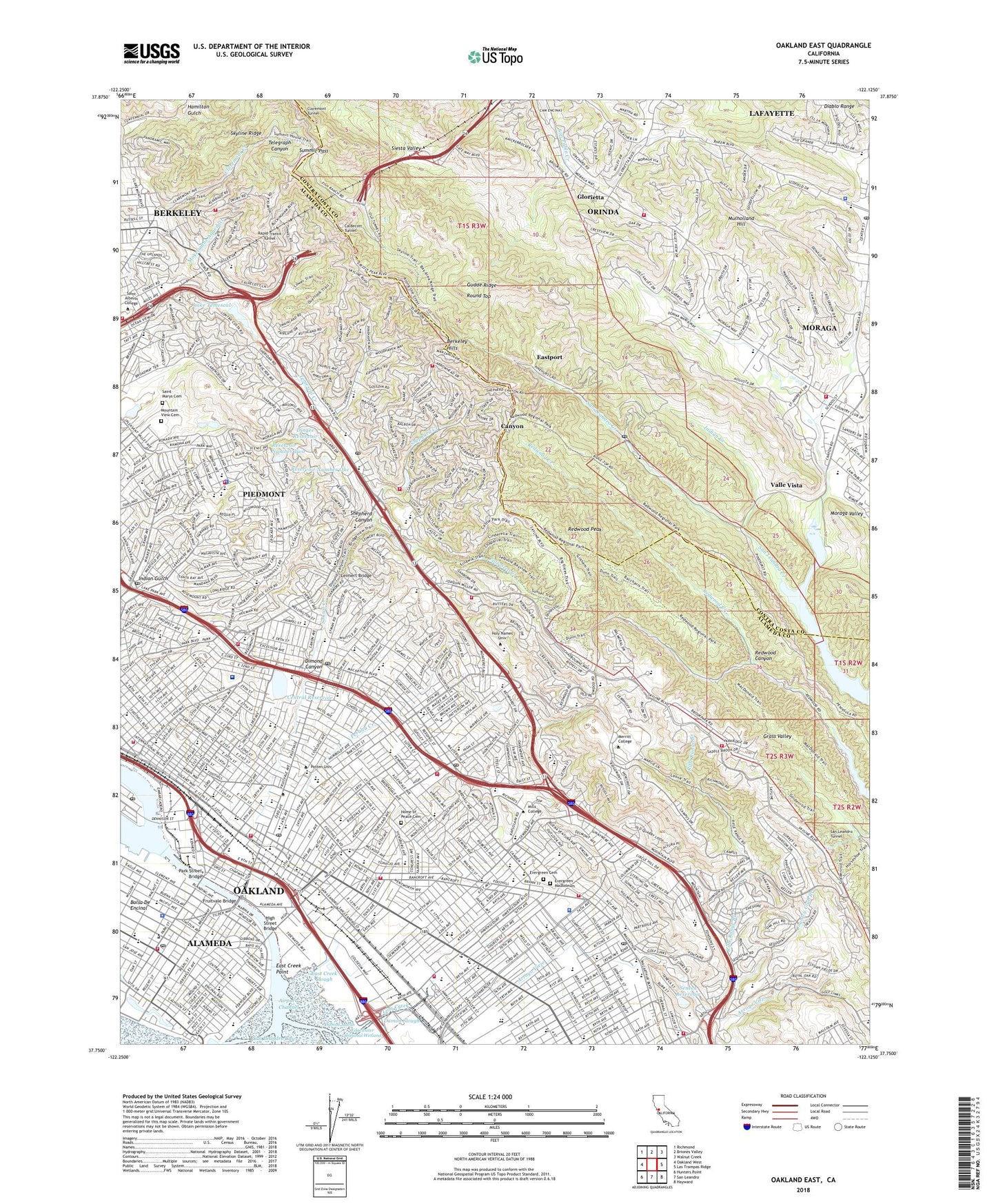
2021 topographic map quadrangle Oakland East in the state of California. Scale: 1:24000. Based on the newly updated USGS 7.5' US Topo map series, this map is in the following counties: Alameda, Contra Costa. The map contains contour data, water features, and other items you are used to seeing on USGS maps, but also has updated roads and other features. This is the next generation of topographic maps. Printed on high-quality waterproof paper with UV fade-resistant inks.
Quads adjacent to this one:
West: Oakland West
Northwest: Richmond
North: Briones Valley
Northeast: Walnut Creek
East: Las Trampas Ridge
Southeast: Hayward
South: San Leandro
Southwest: Hunters Point
This map covers the same area as the classic USGS quad with code o37122g2.
Contains the following named places: Aeolian Yacht Club, Alameda, Alameda Health System Highland Hospital, Alameda High School, Alameda Park, Alameda Station, Allendale, Allendale Elementary School, Allendale Recreation Center, Arroyo Viejo, Arroyo Viejo Recreation Center, Beach Elementary School, Bella Vista Elementary School, Bella Vista Recreation Area, Berkeley Tennis Club, Booth Memorial Hospital, Bret Harte Middle School, Brookdale Park, Brooklyn Basin, Burckhalter Elementary School, Caldecott Tunnel, California Concordia College, California School for Blind and Deaf, Campolindo High School, Canyon, Canyon Elementary School, Castlemont Community of Small Schools, Central 31 Dam, Central Reservoir, Central Reservoir Recreation Area, Chabot Observatory, Chabot Recreation Center, City of Oakland, City of Piedmont, Claremont, Claremont Canyon Regional Preserve, Claremont Country Club, Claremont Creek, Claremont Tunnel, Cleveland Elementary School, Coast Guard Island, Coast Guard Station Oakland, Coliseum Gardens, Concordia Park, Country Club Branch, Crocker Highlands, Crocker Highlands Elementary School, Crocker Park, Damon Marsh, Damon Slough, Damon Station, Davie Stadium, Del Rey Elementary School, Dimond Canyon, Dimond Canyon Park, Dimond District, Dingee Reservoir, Donald Rheem Elementary School, Dracena Park, East Creek Point, East Creek Slough, East Oakland Station, Eastmont, Eastmont Mall Shopping Center, Eastport, Edgewater Seasonal Wetland, Edison Elementary School, Eightyeighth Avenue Mini Park, Eightyfifth Avenue Mini Park, Elmhurst, Estates 31-010 Dam, Evergreen Cemetery, Evergreen Mausoleum, Fairfax Sanitarium, Fernside, Fernside Station, Franklin Elementary School, Fremont Municipal Pool, Fremont Senior High School, Fruitvale, Fruitvale Bridge, Fruitvale Bridge Park, Fruitvale Plaza, Fruitvale Station, Garber Park, Garfield Municipal Playground, Glorietta, Grand Lake, Greeman Field, Gudde Ridge, Hacienda De Las Flores Park, Hamilton Gulch, Havens Elementary School, Havens Playground, Havenscourt, High Street Bridge, High Street Station, Highland Park, Home of Peace Cemetery, Indian Creek, Indian Gulch, Island Yacht Club, Jackson Park, Joaquin Miller Park, Kennedy Tract Park, Knowland State Arboretum and Park, KPFA-FM (Berkeley), Krusi Park, Lake Temescal, Lake Temescal 29 Dam, Lake Temescal Regional Park, Laurel, Lazear Recreation Center, Leimert Bridge, Leona Heights, Leona Heights Park, Leona Quarry, Lincoln Park, Lincoln Square Shopping Center, Lion Creek, Live Oak Memorial Pool, Lockwood Gardens, Lower Edwards 591-002 Dam, Mandana Plaza, Manzanita Recreation Center, Maxwell Park, McCrea Memorial Park, McKinley Park, Melrose, Melrose Station, Millsmont, Montclair, Montclair Playground, Moraga, Moraga Commons Park, Moraga Country Club, Moraga Shopping Center, Moraga Substation, Morgan Plaza, Mountain View Cemetery, Mulholland Hill, Municipal Rose Garden, Naval Hospital Heliport, North Oakland Regional Sports Cente, Oak Knoll Naval Hospital, Oakland Division, Oakland Hospital, Orinda Oaks Park, Ostrander Park, Otis Elementary School, Overstock.com Coliseum, Pacific Hospital, Palo Seco Creek, Park Boulevard Plaza, Park Street Bridge, Park Street Historic Commerical District, Park Street Station, Peralta Creek, Peralta Hacienda Park, Piedmont, Piedmont 31-011 Dam, Piedmont Park, Piedmont Recreation Center, Piedmont Sports Field, Pinto Ranch Recreation Area, Rainbow Recreation Center, Rapid Transit Tunnel, Redwood Canyon, Redwood Creek, Redwood Heights, Redwood Heights Recreation Center, Redwood Peak, Redwood Regional Park, Reservoir Number One, Reservoir Number Two, Rheem, Rifle Range Branch, Rockridge, Rockridge Park, Round Top, Round Top Regional Park, Saint Alberts College, Saint Mary Cemetery, San Antonio, San Antonio Park, San Leandro Bay, San Leandro Tunnel, Sanborn Park, Sather Station, Sausal Creek, Seminary Park, Seneca 31-026 Dam, Seneca Reservoir, Sequoyah Country Club, Shephard Creek, Shepherd Canyon, Shepherd Canyon Park, Siesta Valley, Skyline Ridge, Smith Park, Strawberry Creek, Sulphur Springs Park, Summit Pass, Tassafaronga Recreation Center, Telecare Heritage Psychiatric Health Facility, Telegraph Canyon, Temescal Creek, Terrace Ave Playground, The Arena in Oakland, Thirtyninth Avenue Reservoir, Thompson Field, Thornhill Station, Tidal Canal, Towata Park, Trestle Glen, Tyson Lake, Upper Edwards 591 Dam, Upper San Leandro Filtration Plant, Valle Vista, Vantage Point Park, Verdese Carter Park, Versailles Station, W D Wood Park, Willow Street Station, ZIP Codes: 94516, 94601, 94602, 94605, 94606, 94610, 94611, 94613, 94618, 94619, 94705