MyTopo
Briones Valley California US Topo Map
Couldn't load pickup availability
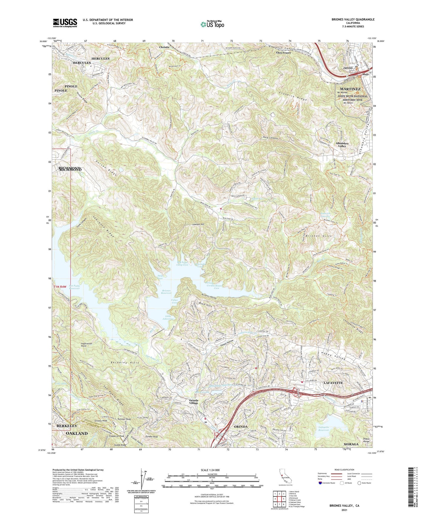
2021 topographic map quadrangle Briones Valley in the state of California. Scale: 1:24000. Based on the newly updated USGS 7.5' US Topo map series, this map is in the following counties: Contra Costa, Alameda. The map contains contour data, water features, and other items you are used to seeing on USGS maps, but also has updated roads and other features. This is the next generation of topographic maps. Printed on high-quality waterproof paper with UV fade-resistant inks.
Quads adjacent to this one:
West: Richmond
Northwest: Mare Island
North: Benicia
Northeast: Vine Hill
East: Walnut Creek
Southeast: Las Trampas Ridge
South: Oakland East
Southwest: Oakland West
This map covers the same area as the classic USGS quad with code o37122h2.
Contains the following named places: Acalanes, Alhambra Creek, Alhambra Valley, Alhambra Valley Census Designated Place, Bear Creek, Bearinda Cove, Berkeley Hills, Black Hills, Boy Scout Camp Cove, Briones 31-015 Dam, Briones Dam, Briones Division, Briones Hills, Briones Regional Park, Briones Reservoir, Briones Valley, Briones Valley School, Chaparral Peak, Charles Lee Tilden Regional Park, City of Orinda, Claremont Water Tunnel, Contra Costa County Fire Protection District Station 16, Contra Costa County Fire Protection District Station 19, Cutter Cove, Deep Cove, East Bay Regional Park District Ambulance Station 1, East Bay Regional Park District Ambulance Station 6, Eureka Peak, Fountainhead Montessori School, Franklin Canyon, Franklin Creek, Franklin Ridge, Frowning Ridge, Glen Frazer, Grizzly Peak, Happy Valley Elementary School, Happy Valley Pumping Plant, Inspiration Point, John Muir National Historic Site, KALX-FM (Berkeley), La Boca De Las Canada Del Pinole, Lafayette 31-002 Dam, Lafayette Police Department, Lafayette Post Office, Lafayette Reservoir, Lafayette Ridge, Lafayette Water Treatment Plant, Lafayette Water Tunnel, Lake Cascade, Lake Orinda 587 Dam, Lauterwasser Creek, Lawrence Hall of Science, Lawson Hill, Little John Cove, Martinez Post Office, Moraga - Orinda Fire District Station 43, Moraga - Orinda Fire District Station 45 Headquarters, Mount Helen, Mount Wanda, Muir, Nike Site SF-09C, Orinda, Orinda Academy, Orinda Branch Contra Costa County Library, Orinda Country Club, Orinda Police Department, Orinda Post Office, Orinda Village, Orinda Water Treatment Plant, Oursan Ridge, Paul Park, Pereira Cove, Pine Grove School, Pinole, Pinole Ridge, San Pablo Reservoir, San Pablo Ridge, Sandhill Heliport, Scow Canyon, Sindicich Lagoons, Sleepy Hollow, Sleepy Hollow Elementary School, Sobrante Ridge, Sunnyside Pumping Plant, Temple Isaiah High School, Tilden Park Golf Course, Tin House Cove, Vaca Canyon, Vallecitos School, Vollmer Peak, ZIP Codes: 94553, 94563