MyTopo
Sacramento East California US Topo Map
Couldn't load pickup availability
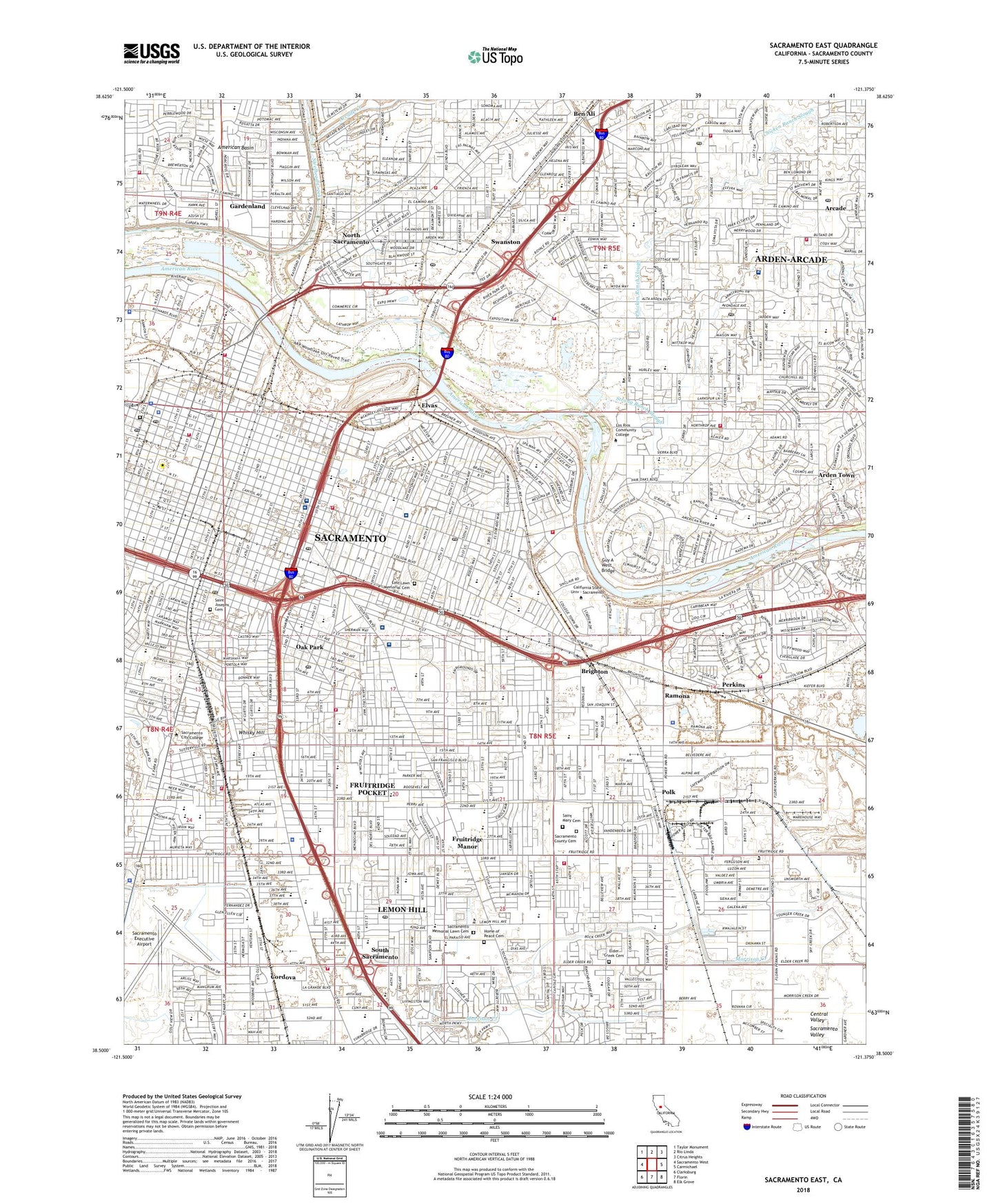
2021 topographic map quadrangle Sacramento East in the state of California. Scale: 1:24000. Based on the newly updated USGS 7.5' US Topo map series, this map is in the following counties: Sacramento. The map contains contour data, water features, and other items you are used to seeing on USGS maps, but also has updated roads and other features. This is the next generation of topographic maps. Printed on high-quality waterproof paper with UV fade-resistant inks.
Quads adjacent to this one:
West: Sacramento West
Northwest: Taylor Monument
North: Rio Linda
Northeast: Citrus Heights
East: Carmichael
Southeast: Elk Grove
South: Florin
Southwest: Clarksburg
This map covers the same area as the classic USGS quad with code o38121e4.
Contains the following named places: Airport Park, Alkali Flat Central Historic District, Alkali Flat North Historic District, Alkali Flat West Historic District, Alkali Playground, Alumni Grove, American Lakes School Park, Applequist Athletic Field, Arcade, Arcade Creek, Arden Fair Mall, Arden Morse Shopping Center, Arden Square Shopping Center, Arden Town, Arden Town Shopping Center, Arden-Arcade Census Designated Place, B T Collins Army Reserve Center, Babcock Park, Baer Park, Bellview Park, Ben Ali, Ben Ali School Park, Bing Maloney Golf Course, Bohemian Park, Bowling Green Park, Brighton, Brockway Park, Bushy Lake, Cal Expo Horse Race Track, California School Park, California State Exposition, California Vietnam Veterans Memorial, Camelia City Shopping Center, Camellia Park, Camp Pollock, Campus Commons Golf Course, Capitol Park, Century Shopping Center, Chicken Ranch Slough, City College Light Rail Station, City of Sacramento, College Greens Shopping Center, Coloma Park, Colonial Playground, Cordova, Corral Lake, Cort-Yard Shopping Center, Cottage Park, Country Club Centre, Country Club Plaza, Courtyard Shopping Center, Crabtree Park, Creekside Oaks Park, Creekside Park, Crown Market Shopping Center, Curtis Park, Da Vinci School Park, Deadmans Lake, Del Paso Country Club, Del Paso Manor Shopping Center, Deterding Park, Dignity Health Mercy General Hospital, Discovery Park, Discovery Plaza Shopping Center, Dixieland Park, Dos Rios School Park, E A Fairbairn Treatment Plant, Earl Warren Park, East Lawn Childrens Park, East Lawn Memorial Cemetery, East Portal Park, East Sacramento, Elder Creek Cemetery, Elvas, Farmers Center Shopping Center, Florin Reservoir Park, Fountain Park Plaza, Freeport Plaza Shopping Center, Freeport Square Shopping Center, Fremont Park, Fruitridge Manor, Fruitridge Park, Fruitridge Pocket Census Designated Place, Fruitridge Shopping Center, Fulton Point Shopping Center, Fulton-Hurley Plaza Shopping Center, Gardenland, Gardenland Park, Glenbrook Park, Governor's Mansion State Historic Park, Granite Park, Grant Playground, Greenfair Park, Guy A West Bridge, Hagginwood School Park, Hall Park, Henschel Park, Highland Park, Hollywood Plaza Shopping Center, Home of Peace Cemetery, Hoos Swimming Pool, Hornet Stadium, Howe Community Park, Hughes Stadium, Jack Davis Park, Jefferson School Park, Johnston Park, Jonas Larkspur Park, Kaiser Permanente Sacramento Medical Center, Kennedy Park, KSAC-AM (Sacramento), KXHV-FM (Sacramento), KXOA-AM (Sacramento), Lake Park Helistop, Lanai Shops Shopping Center, Lawrence Playground, Leland Stanford Mansion State Historic Park, Lemon Hill Census Designated Place, Lemon Hill Shopping Center, Little League Park, Loehmans Plaza Shopping Center, Lubin School Park, Lyon Village Shopping Center, Mangan Park, Maple School Park, Market Square at Arden Fair Shopping Center, Marshall Park, McClatchy Park, McClatchy School Park, McKinley Park, Mueller Corner Shopping Center, Muir Playground, Neely Johnson Park, New Helvetia, Nicholas Park, Ninos Park, North del Rio School Park, North Sacramento, Northgate Park, Northgate Shopping Center, Oak Meadow Park, Oak Park, Oaks Shopping Center, Oki Park, Orville Wright Park, P Z Cervantes Park, Pacific Park, Parkway-South Sacramento Census Designated Place, Pavilions Shopping Center, Perkins, Phillips School Park, Plaza Park, Plaza Shopping Center, Point West Plaza Shopping Center, Polk, Rainbow Mini Park, Ramona, Redwood Park, Richardson Village Park, River Park, River Park Shopping Center, Riverfront Park, Roosevelt Park, Sacramento, Sacramento Armory, Sacramento Army Depot, Sacramento County Cemetery, Sacramento Division, Sacramento Executive Airport, Sacramento Memorial Lawn Cemetery, Sacramento School Park, Saint Josephs Cemetery, Saint Mary Cemetery, Saint Rose Cemetery, Santa Anita Park, Seely Park, Seventeenth Avenue Park, Sierra School Park, Sierra Vista Park, Sim Park, Sky View Drive-In, South Sacramento, Southern Pacific Shops, Stanford Playground, Stockridge Plaza Shopping Center, Stone Creek Center Shopping Center, Strauch School Park, Strong Ranch Slough, Sunset Park, Sutter Square Galleria Shopping Center, Sutter's Fort, Sutter's Fort State Historic Park, Swanston, Swanston Park, Tahoe Park, Tallac Village Shopping Center, Taylor Shopping Center, Temple Avenue Park, The Midway Shopping Center, Town and Country Village, Town and Country Village Shopping Center, Triangle Park, Twain School Park, Twenty-First Avenue Parkway, UCDMC Heliport, Union Stadium, United States Coast Guard - Air Station Sacramento, University Village Shopping Center, Washington Park, Waterworld USA, Wells Fargo Pavilion, Western Pacific Shops, Whisky Hill, William Land Municipal Golf Course, William Land Park, Winn Park, Winterstein Park, Wood School Park, Woodbine Park, Woodbine School Park, Woodlake Park, Zapata Park, ZIP Codes: 95811, 95814, 95815, 95816, 95817, 95818, 95819, 95820, 95822, 95824, 95825, 95826, 95864