
MyTopo
Selma California US Topo Map
Couldn't load pickup availability
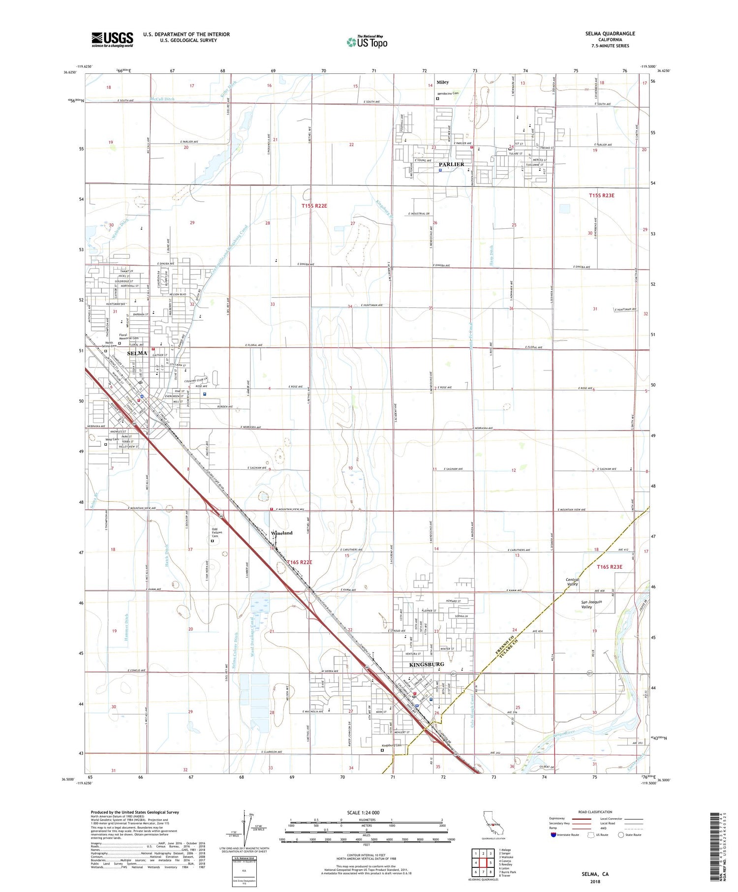
2021 topographic map quadrangle Selma in the state of California. Scale: 1:24000. Based on the newly updated USGS 7.5' US Topo map series, this map is in the following counties: Fresno, Tulare. The map contains contour data, water features, and other items you are used to seeing on USGS maps, but also has updated roads and other features. This is the next generation of topographic maps. Printed on high-quality waterproof paper with UV fade-resistant inks.
Quads adjacent to this one:
West: Conejo
Northwest: Malaga
North: Sanger
Northeast: Wahtoke
East: Reedley
Southeast: Traver
South: Burris Park
Southwest: Laton
This map covers the same area as the classic USGS quad with code o36119e5.
Contains the following named places: Berry Park, Bethel Temple Church of Kingsburg, Bicentennial Park, Bitters Selma Shopping Center, Brentlinger Park, Caesar Ditch, Canal School, Cathedral of Light Church, Centerville and Kingsburg Canal, Central Valley Baptist Church, Cesar E Chavez Elementary School, Church of Christ, Church of God, Church of the Nazarene, Church of the Redeemer, Church of the United Brethren in Christ, City of Kingsburg, City of Parlier, City of Selma, Clay Elementary School, Colony Covenant Church, Community Bible Fellowship Church, Concordia Lutheran Church, Danish Church, Earl Ruth Park, Evangelical Free Church, Evangelical Mission Covenant Church, First Armenian Presbyterian Church, First Baptist Church, First Christian Church, First Freewill Baptist Church, First Methodist Episcopal Church, First Presbyterian Church, First Southern Baptist Church, First United Methodist Church, Floral Memorial Cemetery, Franklin School, Fresno County Fire Protection District Selma Station 83, Fruitvale School, Full Gospel Assembly of God Tabernacle, Full Gospel of God Tabernacle, Garfield Elementary School, Hammer Ditch, Harp Ditch, Harrison School, Hatch Ditch, Heartland Alternative Educational Center, Holy Family Catholic Church, Indianola Elementary School, Jackson Elementary School, John C Martinez Elementary School, Kingdom Hall of Jehovahs Witnesses, Kingsburg, Kingsburg Branch, Kingsburg Buddhist Church, Kingsburg Cemetery, Kingsburg City Hall, Kingsburg City Park, Kingsburg Division, Kingsburg Fire Department, Kingsburg High School, Kingsburg Joint Alternative Education School, Kingsburg Medical Center, Kingsburg Police Department, Kingsburg Post Office, Kingsburg United Methodist Church, Kirby Ditch, Lincoln Elementary School, Lincoln Park, Lund Farms, Mathew J Brletic Elementary School, McCall Ditch, Memorial Park, Mendocino Cemetery, Mennonite Brethren Church, Miley, Mulligan Farm, New Life Temple, North Selma Cemetery, Oasis Continuation School, Odd Fellows Cemetery, Paiva Intercity Landing Field, Parlier, Parlier City Hall, Parlier High School, Parlier Police Department, Parlier Post Office, Parlier Volunteer Fire Department, Parlier-Del Rey Division, Pella Lutheran Church, Rafer Johnson Junior High School, Roosevelt Elementary School, Ross School, Saint Josephs Catholic Church, Saint Pauls Lutheran Church, Sal M Salazar Community Center, Sal M Salazar Park, Santa Fe Canal, Selma, Selma Adult School, Selma Apostolic Assembly Church, Selma Branch Fresno County Free Library, Selma City Fire Department Station 2, Selma City Hall, Selma Colony Ditch, Selma Community Center, Selma Fire Department Station 1, Selma High School, Selma Landing Field, Selma Police Department, Selma Post Office, Selma Sanitarium, Selma Speedway, Spanish Church of the Nazarene, Swedish Mission, Theodore Roosevelt Elementary School, Trinity Life Assembly Church, Valley Christian Academy, W H Shaver Park, Walnut Ditch, Walnut School, Washington Elementary School, West Cemetery, Wineland, Woodrow Wilson Elementary School, ZIP Code: 93648


