MyTopo
Taft California US Topo Map
Couldn't load pickup availability
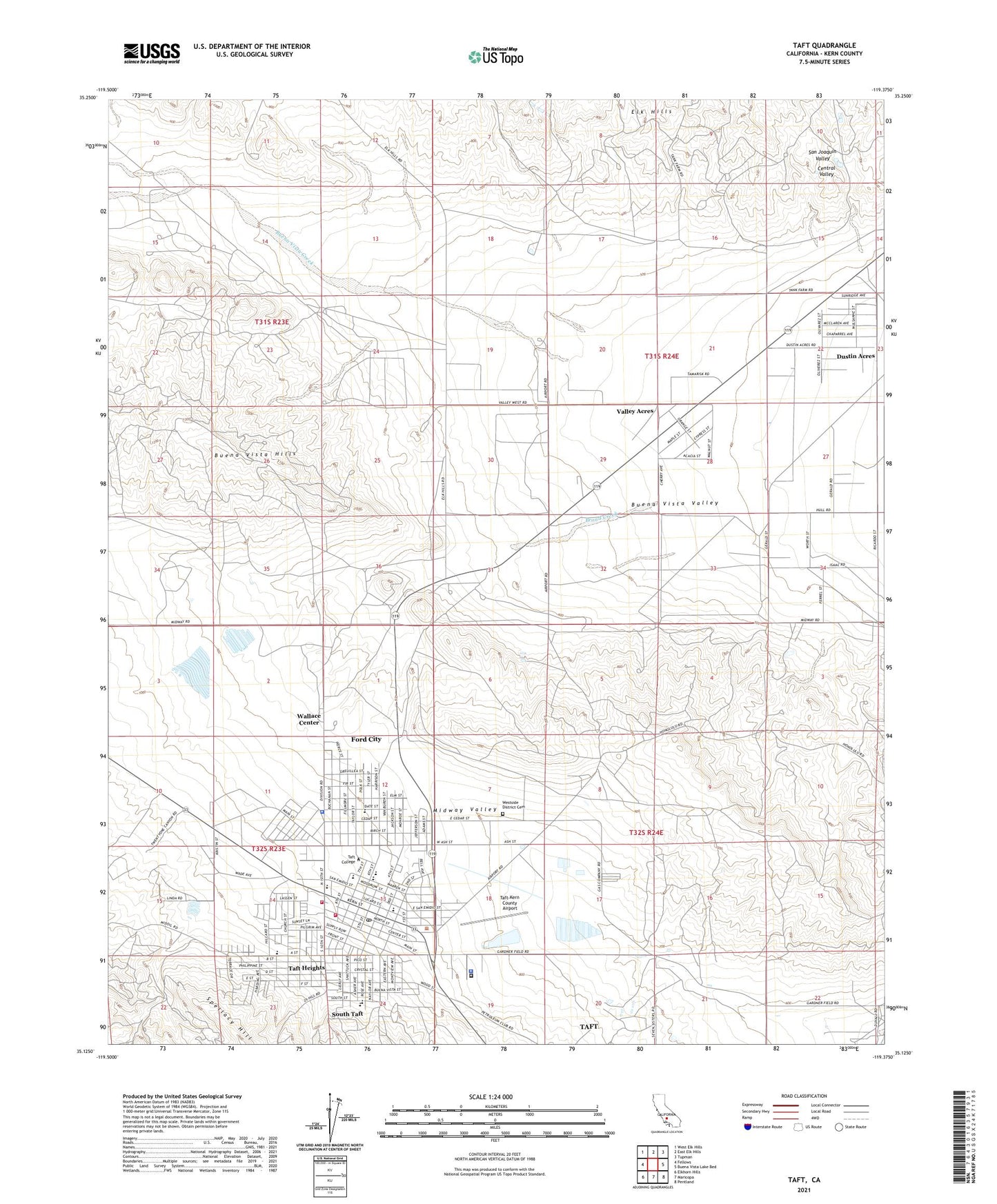
2021 topographic map quadrangle Taft in the state of California. Scale: 1:24000. Based on the newly updated USGS 7.5' US Topo map series, this map is in the following counties: Kern. The map contains contour data, water features, and other items you are used to seeing on USGS maps, but also has updated roads and other features. This is the next generation of topographic maps. Printed on high-quality waterproof paper with UV fade-resistant inks.
Quads adjacent to this one:
West: Fellows
Northwest: West Elk Hills
North: East Elk Hills
Northeast: Tupman
East: Buena Vista Lake Bed
Southeast: Pentland
South: Maricopa
Southwest: Elkhorn Hills
This map covers the same area as the classic USGS quad with code o35119b4.
Contains the following named places: A Street Park, Assembly of God Church, Broad Creek, Buena Vista High School, Buena Vista Hills, Buena Vista Mobile Home Park, Bureau of Land Management - Midway Fire Station, California Department of Natural Resources, Calvary Temple Assembly of God Church, Church of Christ, Church of God, City of Taft, Civic Center Park, Community Christian Fellowship Church, Conley Elementary School, Cougar Sports Center, Dustin Acres, First Assembly of God Church, First Baptist Church, First Church of Christ Scientist, First Presbyterian Church, First Southern Baptist Church, First United Methodist Church, Ford City, Ford City Census Designated Place, Ford City Missionary Baptist Church, Ford City Park, Foursquare Church, Franklin Field, Gospel Tabernacle, Hall Mart Shopping Center, Honolulu Oil Main Camp, Jefferson Elementary School, Kern County Fire Department Station 21 Taft, Kern County Sheriff's Office, KMYX-AM (Taft), KZPE-FM (Ford City), Laborers of the Harvest Church, Lincoln Elementary School, Mercy Westside Hospital, New Hope Temple, Oasis Christian Church, Parkview Elementary School, Peace Lutheran Church, Petroleum Club, Regency Nursing Home, Roosevelt Elementary School, Saint Andrews Episcopal Church, Saint Marys Convent, Saint Marys School, Seventh Day Adventist Church, South Taft, South Taft Census Designated Place, Southern Calif Gas Camp, Spellacy Hill, Standard Oil Camp Eleven-C, Standard Oil Camp Five-D, Standard Oil Camp Nine-D, Standard Oil Camp One-C, Standard Oil Tank Farm, Taft, Taft Branch Kern County Library, Taft Chamber of Commerce, Taft City Corporation Yard, Taft City Hall, Taft City Police Department, Taft Civic Center, Taft College, Taft College Library, Taft Community Center, Taft Heights, Taft Heights Census Designated Place, Taft Heights Kindergarten, Taft Hills Plaza Shopping Center, Taft Medical Center, Taft Modified Community Correctional Facility, Taft Post Office, Taft Primary School, Taft Union High School, Taft-Kern County Airport, The Church of Jesus Christ of Latter Day Saints, United States Geological Survey Camp - Oil and Gas Division, Valley Acres, Valley Acres Census Designated Place, Veterans Memorial Building, Wallace Center, West Kern Oil Museum, West Side Hospital Heliport, Westside District Cemetery, Westside Shopping Center, ZIP Code: 93268