MyTopo
Cortez Colorado US Topo Map
Couldn't load pickup availability
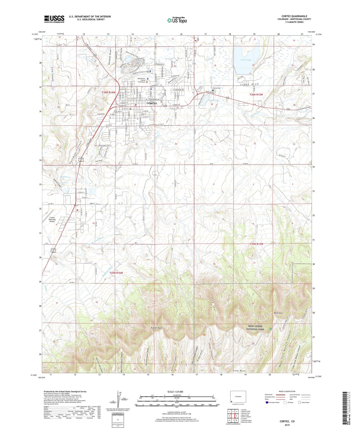
2019 topographic map quadrangle Cortez in the state of Colorado. Scale: 1:24000. Based on the newly updated USGS 7.5' US Topo map series, this map is in the following counties: Montezuma. The map contains contour data, water features, and other items you are used to seeing on USGS maps, but also has updated roads and other features. This is the next generation of topographic maps. Printed on high-quality waterproof paper with UV fade-resistant inks.
Quads adjacent to this one:
West: Mud Creek
Northwest: Arriola
North: Dolores West
Northeast: Dolores East
East: Point Lookout
Southeast: Moccasin Mesa
South: Wetherill Mesa
Southwest: Towaoc
This map covers the same area as the classic USGS quad with code o37108c5.
Contains the following named places: Axis Health System Cortez Office, Baptist Chapel, Calkins Junior High School, Centennial Park, Church of Christ, City of Cortez, Colorado Welcome Center, Conquistador Golf Course, Cortez, Cortez Cemetery, Cortez Center, Cortez City Hall, Cortez City Park, Cortez Fire Protection District Station 1, Cortez Fire Protection District Station 2, Cortez Fire Protection District Station 3, Cortez Mine, Cortez Plaza Shopping Center, Cortez Police Department, Cortez Post Office, Cortez Public Library, Crow Canyon, Denny Lake, Denny Lake Dam, Denny Lake Park, Denny Park, Downey Elementary School, Downey School, Evangel Assembly of God, Faith Bible Church, First Baptist Church, First Southern Baptist Church, First United Methodist Church, Hartman Canyon, Hartman Draw, Highline Ditch, Justice Building, Kemper Elementary School, Kemper School, KISZ-AM (Cortez), Krueger Point, Long Mesa, Long Spur, Manaugh Elementary School, McElmo Falls, Mesa Elementary School, Mesa Park and Environmental Lab, Mitchell Springs Mine, Montezuma - Cortez Middle School, Montezuma Cortez Re 1 Pre School, Montezuma County, Montezuma County Community Center, Montezuma County Court House, Montezuma County Jail, Montezuma County Senior Center, Montezuma County Sheriff's Office, Montezuma Mine, Montezuma Park, Montezuma Valley, Montezuma Valley Presbyterian Church, Montezuma-Cortez High School, Montezuma-Cortez School District, Mowry Mine, New Life Chapel, North Rim, Robert Leighton Dam, Robert Leighton Reservoir, Rocky Ford Ditch, Saint Margaret Mary Catholic Church, Seventh Day Adventist Church, Seventh Day Adventist School, Simon Draw, Southwest Memorial Hospital, Southwest Memorial Hospital Emergency Medical Services, The Chapel, The Church of Jesus Christ of Latter Day Saints, Todd Mine, Totten Dam, Totten Lake, University of Colorado Center, Upper Navajo Canyon Trail, Vista Grande Nursing Home, Wilson Mines