MyTopo
Erie Colorado US Topo Map
Couldn't load pickup availability
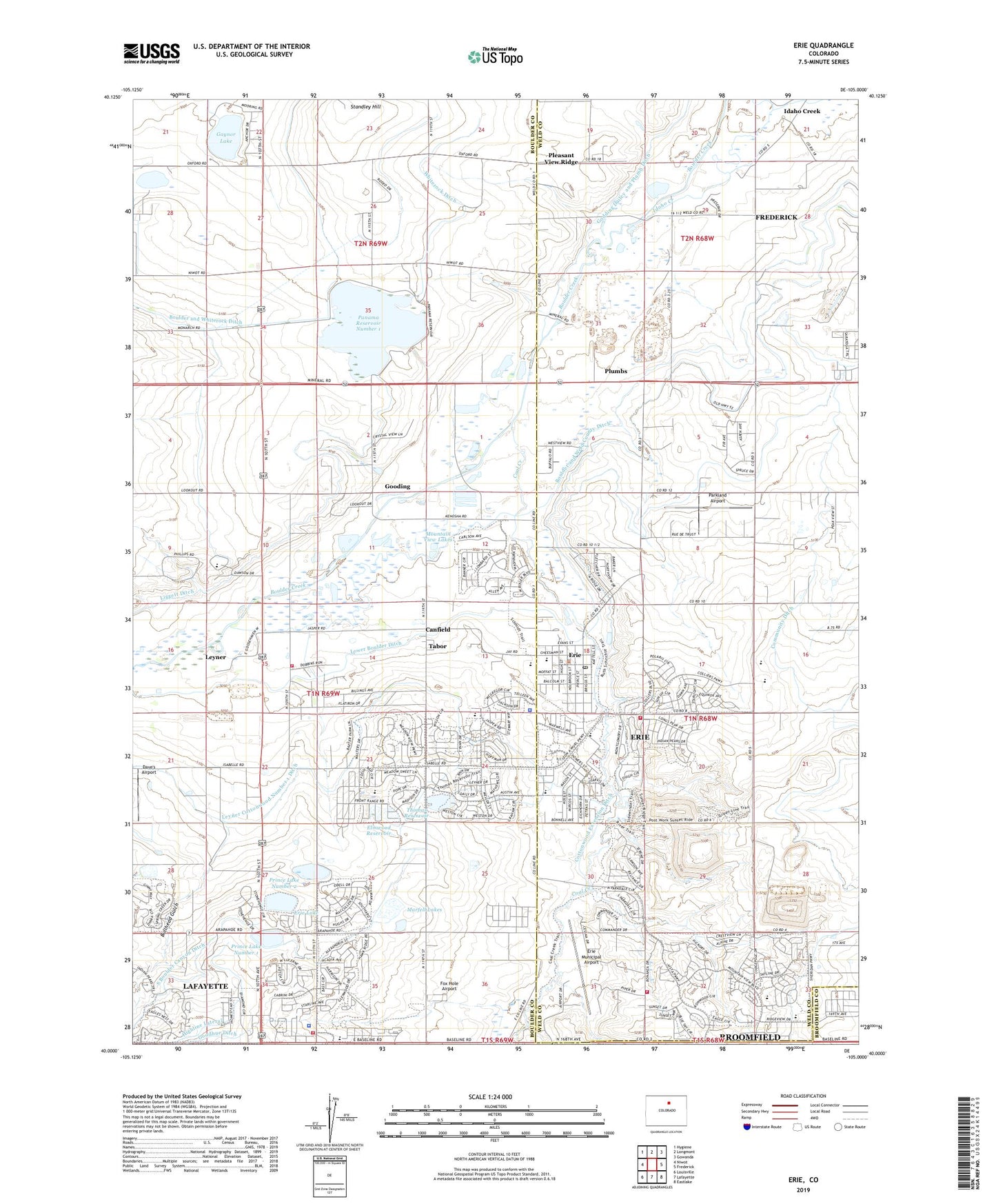
2022 topographic map quadrangle Erie in the state of Colorado. Scale: 1:24000. Based on the newly updated USGS 7.5' US Topo map series, this map is in the following counties: Boulder, Weld, Broomfield. The map contains contour data, water features, and other items you are used to seeing on USGS maps, but also has updated roads and other features. This is the next generation of topographic maps. Printed on high-quality waterproof paper with UV fade-resistant inks.
Quads adjacent to this one:
West: Niwot
Northwest: Hygiene
North: Longmont
Northeast: Gowanda
East: Frederick
Southeast: Eastlake
South: Lafayette
Southwest: Louisville
This map covers the same area as the classic USGS quad with code o40105a1.
Contains the following named places: Alexander Dawson School, Aspen Ridge Preparatory School, Bailey Gravel Pit, Black Rock Elementary School, Boulder and Weld County Ditch, Boulder Valley Mine, Brennan Mine, Briggs Mine, Bullhead Gulch, C and M Gravel Pit, Canfield, Carr and Tyler Ditch, Chase Mine, Clayton Mine, Cleveland Mine, Coal Creek, Colorado National Golf Club, Columbine Mine, Cottonwood Extension Ditch, Crandell Number One Mine, Dave's Airport, Denver Regional Landfill, Elmwood Dam, Elmwood Reservoir, Erie, Erie Dam, Erie Elementary School, Erie Filtration Plant, Erie High School, Erie Lake, Erie Middle School, Erie Mine, Erie Municipal Airport, Erie Pit, Erie Police Department, Erie Post Office, Escuela Bilingue Pioneer School, Eureka Number One Mine, Excelsior Mine, Fox Hole Airport, Garfield Mine, Garfield Number Two Mine, Gaynor Dam, Gaynor Lake, Gladstone Mine, Godding Dailey and Plumb Ditch, Gooding, Hayward Mine, Idaho Creek, Jackson Mine, Lafayette Fire Department, Lafayette Police Department, Lafayette Public Library, Lehigh Mine, Leyner, Leyner Census Designated Place, Leyner Cottonwood Number 1 Ditch, Leyners Hayfield Airport, Liggett Ditch, Lister Mine, Lloyd Mine, Longs Peak Mine, MacGregor Mine, Marfell Lake Number 1, Marfell Lake Number 1 Dam, Marfell Lakes, Marfell Mine, Mile Hi Mine, Mitchell Mine, Mitchell Number Two Mine, Monroe Mine, Mountain View Fire Protection District Station 5 Brownsville, Mountain View Fire Rescue Station 6 Erie, Mountain View Lakes, New Star Mine, Ninemile Corner, North Colorado Med Evac, Northrup Mine, Northwestern Mine, Pallotts Coal Workings, Panama Number 1 Dam, Panama Reservoir Number 1, Paramount Mine, Park Mine, Parkland Airport, Pinnacle Mine, Pleasant View Ridge, Plumbs, Prince Lake Number One, Prince Lake Number Two, Prince Number 1 Dam, Prince Number 2 Dam, Red Hawk Elementary School, Reliance Mine, Simpson Coal Mine, South Boulder Canyon, Standley Hill, Star Mine, State Pit, Stewart Mine, Stuart Mine, Tabor, Thomas Reservoir, Town of Erie, Tri-County Heliport, Tynan Mine, Vista Ridge Academy, Warwick Mine, Washington Mine, Whiterock Ditch, ZIP Codes: 80026, 80516