MyTopo
Frederick Colorado US Topo Map
Couldn't load pickup availability
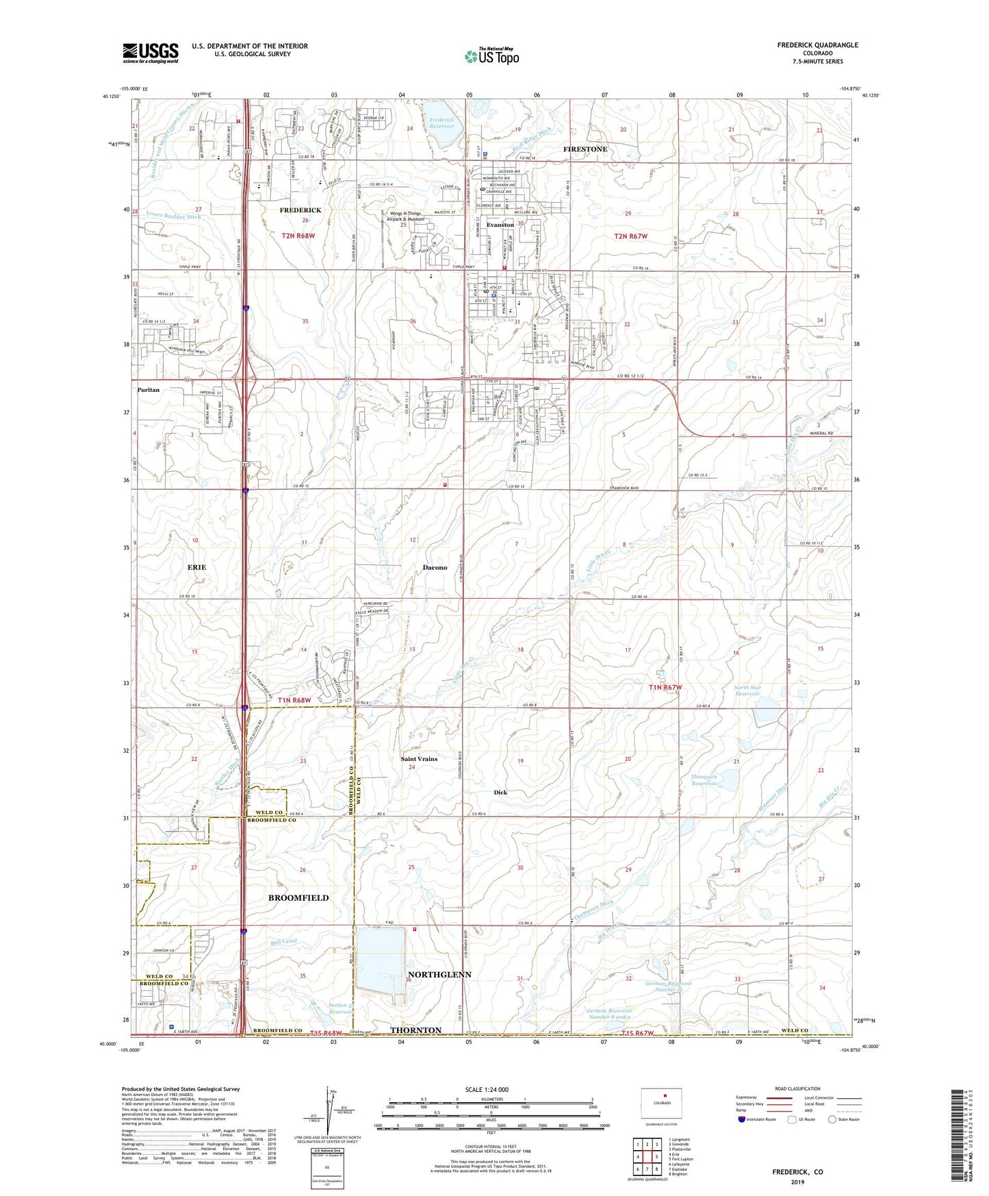
2022 topographic map quadrangle Frederick in the state of Colorado. Scale: 1:24000. Based on the newly updated USGS 7.5' US Topo map series, this map is in the following counties: Weld, Broomfield, Adams. The map contains contour data, water features, and other items you are used to seeing on USGS maps, but also has updated roads and other features. This is the next generation of topographic maps. Printed on high-quality waterproof paper with UV fade-resistant inks.
Quads adjacent to this one:
West: Erie
Northwest: Longmont
North: Gowanda
Northeast: Platteville
East: Fort Lupton
Southeast: Brighton
South: Eastlake
Southwest: Lafayette
This map covers the same area as the classic USGS quad with code o40104a8.
Contains the following named places: AirLife Denver, Baum Mine, Boulder Valley Mine, Bull Ditch, Carbon Valley Academy, Carbon Valley Recreation Center, Children's Hospital Colorado North Campus, Children's House of Weld County, City of Dacono, Cleland Dairy Farms, Crandalls New Mine, Dacono, Dacono Police Department, Dacono Post Office, Davis Mine, Dick, Eagle Mine, Emerson Mine, Erie-Frederick Division, Eureka Mine, Evans Mine, Evanston, Firestone, Firestone Lake, Firestone Mine, Firestone Police Department, Firestone Post Office, Firestone Town Hall, Frederick, Frederick - Firestone Fire Protection District Station 1, Frederick - Firestone Fire Protection District Station 2, Frederick Dam, Frederick Elementary School, Frederick High School, Frederick Middle School, Frederick Mine, Frederick Police Department, Frederick Post Office, Frederick Reservoir, Front Range Dairy, German Number 12 Dam, German Number 8 and 9 Dam, German Reservoir Number 12, German Reservoir Number 8 and 9, Golden Pit, Graden Mine, Grant Mine, Grayden Mine, Hingley Coal Property Mine, Ideal Mine, Imperial Mine, Jones-Evan Mine, KDHT-FM (Greeley), KRZN-AM (Thornton), KZJG-TV (Longmont), Legacy Elementary School, Lincoln Mine, Louisville Coal and Land Number One Mine, Maxwell Mine, McKissick Mine, Morgan Shaft, Morrison Mine, Mount View School, Mountain View Fire Protection District Station 7 Dacono, Mountain View School, National, New Shaft, North Metro Fire - Rescue Department Station 68, North Metro Fire Rescue District Training Center, North Star Dam, North Star Reservoir, Pleasant Valley School, Puritan, Puritan Mine, Russell Mine, Saint Vrain Pit, Saint Vrains, Section 35 Dam, Section 35 Reservoir, Shamrock Mine, Stanley Ditch, Stanley Lateral Ditch, State Coal Mine Junction, Sterling Mine, Suckla Farms Balloonport, Thompson Dam, Thompson Ditch, Thompson Reservoir, Town of Frederick, Warwick Mine, Washington Mine, Whitehouse Mine, Wings N Things Airpark & Museum, Wolff Lease Mine, Yoxall Ditch, ZIP Codes: 80514, 80520, 80530