MyTopo
Niwot Colorado US Topo Map
Couldn't load pickup availability
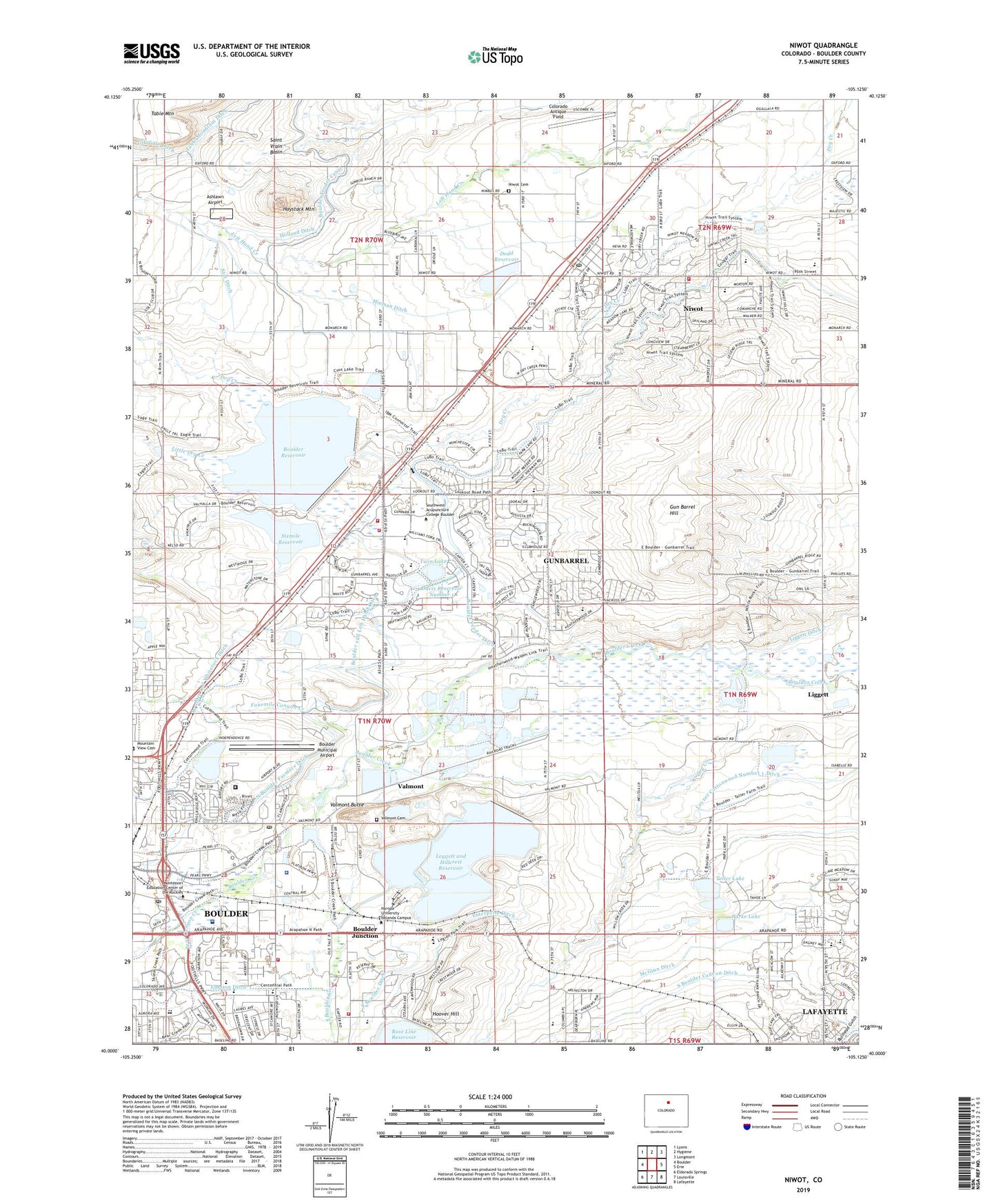
2022 topographic map quadrangle Niwot in the state of Colorado. Scale: 1:24000. Based on the newly updated USGS 7.5' US Topo map series, this map is in the following counties: Boulder. The map contains contour data, water features, and other items you are used to seeing on USGS maps, but also has updated roads and other features. This is the next generation of topographic maps. Printed on high-quality waterproof paper with UV fade-resistant inks.
Quads adjacent to this one:
West: Boulder
Northwest: Lyons
North: Hygiene
Northeast: Longmont
East: Erie
Southeast: Lafayette
South: Louisville
Southwest: Eldorado Springs
This map covers the same area as the classic USGS quad with code o40105a2.
Contains the following named places: Anderson Heliport, Arapahoe Ridge High School, Arapahoe School, Ashlawn Airport, Base Line School, Bear Canyon Creek, Bethany Baptist Church, Boulder and Left Hand Ditch, Boulder and Whiterock Ditch, Boulder Community Health Hospital, Boulder Community School of Integrated Studies, Boulder Country Club, Boulder Country Day School, Boulder County Jail, Boulder County Sheriff's Office, Boulder County Sheriff's Office Warrants Division, Boulder Dam, Boulder Division, Boulder Feeder Ditch, Boulder Fire / Rescue Department Station 6, Boulder Fire / Rescue Department Station 7, Boulder Jewish Day School, Boulder Junction, Boulder Municipal Airport, Boulder Preparatory Charter High School, Boulder Reservoir, Boulder Rural Fire Department Station 1, Boulder Technical Education Center, Boulder Valley Waldorf School, Brannan Sand and Gravel Company Pit, Burke Lake, Cherryvale Fire Protection District Station 2, City of Boulder Wastewater Treatment Facility, City On the Hill Church, Colorado Antique Field, Colorado Brick Pit, Davis Number 1 Dam, Davis Number 2 Dam, Davis Reservoir Number 1, Davis Reservoir Number 2, Dodd Dam, Dodd Reservoir, Douglas Elementary School, Dry Creek, Dry Creek Davidson Ditch, East Boulder Ditch, Eisenhower Elementary School, Empson Ditch, Enterprise Ditch, Eternal Savior Lutheran Church, Flatiron Sand and Gravel Pit, Fourmile Canyon Creek, Friends School, Front Range Community College - Boulder Campus, Goodview Park, Green Ditch, Gun Barrel Hill, Gunbarrel, Gunbarrel Census Designated Place, Gunbarrel Family Medicine, Gunbarrel Shopping Center, Hayden Dam, Hayden Lake, Haystack Mountain, Haywood Mine, Heatherwood Elementary School, High Peaks Elementary School, Hillcrest Reservoir, Hinman Ditch, Holland Ditch, Hoover Hill, IBM Building 910 Heliport, IBM Plant Site Heliport, Jehovah's Witnesses, Jones Donnelly Ditch, Lafayette Filtration Plant, Leggett and Hillcrest Dam, Leggett and Hillcrest Reservoir, Leggett Reservoir, Liggett, Little Dry Creek, Lower Boulder Ditch, McGinn Ditch, Mountain Shadows Montessori School, Mountain View Fire Rescue Station 4 Niwot, Nevin Platt Middle School, New Girl Mine, Niwot, Niwot Cemetery, Niwot Census Designated Place, Niwot Elementary School, Niwot High School, Niwot Post Office, North Boulder Farmers Ditch, Pastore Pit, Pleasant View School, Potts Field, Quest Academy, Rocky Mountain Christian Academy, Rocky Mountain Christian Church, Rocky Mountain School for the Gifted and Creative, Running River School, Sage Elementary School, Saint Joe Dam, Saint Joe Reservoir, Saint Vrain Basin, Saints Peter and Paul Greek Orthodox Church, Six Mile Dam, Sixmile Reservoir, Skunk Creek, South Boulder Creek, Southwest Acupuncture College Boulder, Star Ditch, Table Mountain Ditch, Teller Lake, Teller Lake Number 5, Teller Lake Number 5 Dam, Twin Lake, United States Postal Service Annex, Valmont, Valmont 'A' Dam, Valmont Butte, Valmont Cemetery, Valmont Census Designated Place, Valmont Post Office, Valmont Reservoir, Van Educational Center, ZIP Codes: 80301, 80544