MyTopo
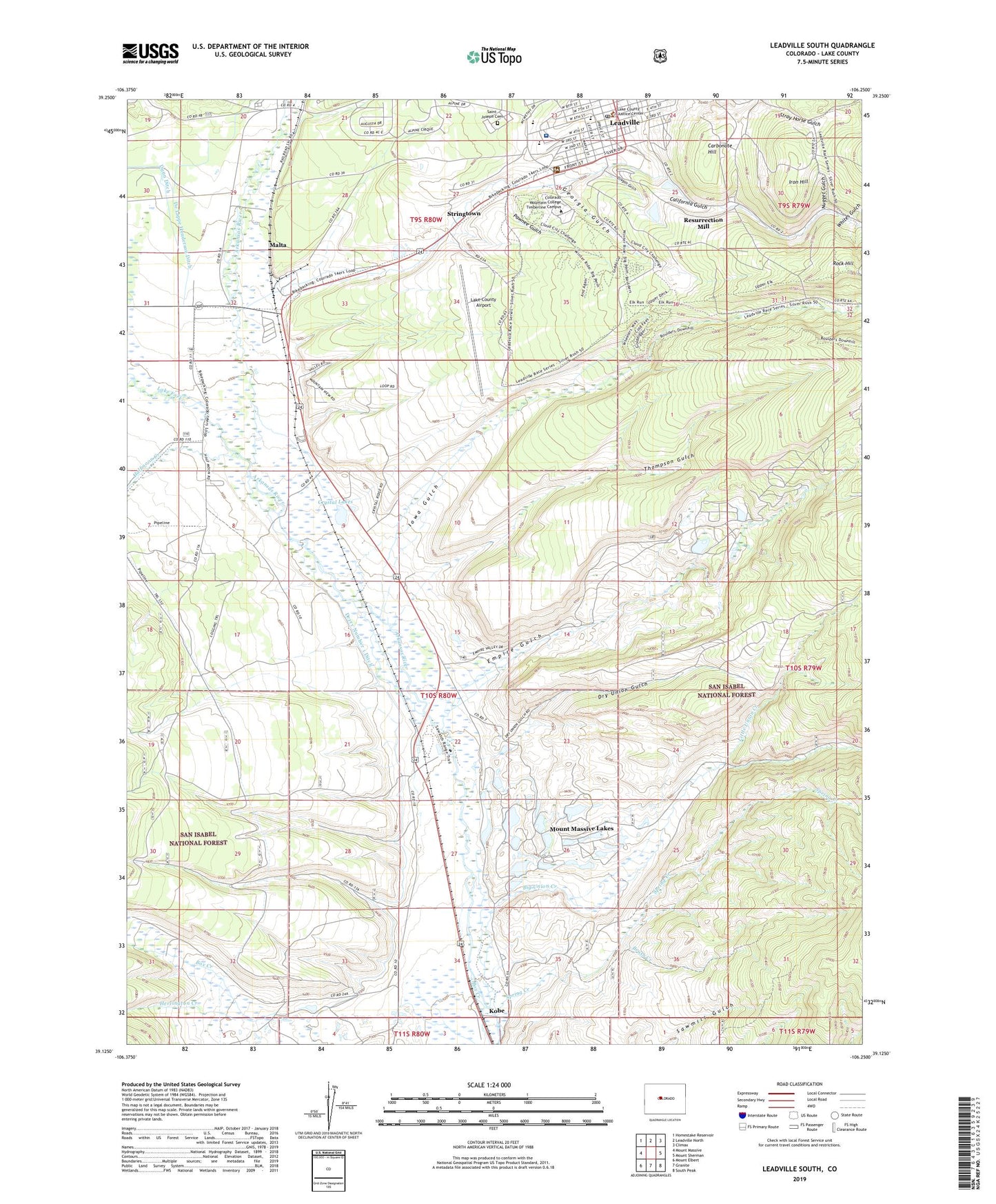
Leadville South Colorado US Topo Map
Couldn't load pickup availability
Also explore the Leadville South Forest Service Topo of this same quad for updated USFS data
2022 topographic map quadrangle Leadville South in the state of Colorado. Scale: 1:24000. Based on the newly updated USGS 7.5' US Topo map series, this map is in the following counties: Lake. The map contains contour data, water features, and other items you are used to seeing on USGS maps, but also has updated roads and other features. This is the next generation of topographic maps. Printed on high-quality waterproof paper with UV fade-resistant inks.
Quads adjacent to this one:
West: Mount Massive
Northwest: Homestake Reservoir
North: Leadville North
Northeast: Climax
East: Mount Sherman
Southeast: South Peak
South: Granite
Southwest: Mount Elbert
This map covers the same area as the classic USGS quad with code o39106b3.
Contains the following named places: A V Mine, Adelaide, Aetna Mine, Agassiz Mine, Badger State Mine, Bates Mine, Belgian Mine, Ben Burb Shaft, Benton Mine, Bessie Wilgus Shaft, Big Chief Mine, Big Union Creek, Bison Shaft, Blind Tom Mine, Boehmer Mine, Bohn Mine, Bon Air Mine, Box Creek, Brush Creek, Bullseye Mine, Burton Placer Mine, California Gulch, Carbonate Hill, Carbonate Mine, Castle View Mine, Catalpa Mine, Chicago Mine, City of Leadville, Clarendon Placer Mine, Cloud City Shaft, Codfish Balls Mine, Colorado Mountain College Leadville Campus, Columbia Number 2 Mine, Columbia Tunnel Mine, Contract Shaft, Coon Valley Mine, Cord Mine, Corske Creek, Crescent Mine, Crescentia Shaft, Crown Point Mine, Crystal Lakes, Crystal Lakes Work Center, De Lappe Ditch, De Lappe Henderson Ditch, Derry Number 1 Ditch, Dodridge Mine, Double Decker Mine, Doublecheck Mine, Dry Union Gulch, East Flagstaff Mine, Emmett Mine, Empire Gulch, Evelyn Mine, Evening Star Mine, Fairview Mine, Fanny Rawlins Mine, Gallagher Mine, Gambetta Mine, Georgia Gulch, Glass-Pendery Mine, Gleason Mine, Great O'Sullivan Mine, Habendum Mine, Halfmoon Creek, Hegeman Mine, Henrietta Mine, Herrington Creek, Hess Tunnel Mine, Highland Mary Tunnel Mine, Home Extension Mine, Iowa Gulch, Iowa Gulch Mine, Iron Hill, J R Loker Mine, Johnson Mine, Kathy K Mine, Keno Shaft, Kobe, KRMH-AM (Leadville), KRMH-FM (Leadville), Kroll Mine, Lake County, Lake County Airport, Lake County High School, Lake County Landfill, Lake County Sheriff's Office, Lake County Sheriff's Office Jail, Lake Fork, Lazy Bill Mine, Leadville District Mine, Leadville Division, Leadville Historic District, Leadville Post Office, Little Giant Mine, Little Sister Placer Mine, Little Union Creek, Louisville Mine, Mahala Mine, Malta, Malta Substation, Midas Mine, Midland Shaft, Mikado Mine, Mike Mine, Minnie Pump Shaft, Modest Girl Mine, Moffat Mine, Montgomery Mine, Mount Massive Golf Course, Mount Massive Lakes, Moyer Mine, Murray Tunnel Mine, National Placer Mine, Niles Mine, North Mike Mine, Nugget Gulch, O'Donovan Rosa Shaft, Only Chance Mine, Oregon Gulch, Oro, Oro City Shaft, Ostrom Mine, Pawnee Gulch, Pima Placer Mine, Porter Mine, Pos Shaft, Prospect Mountain Mine, Pyrenees Mine, Red Head Shaft, Reindeer Shaft, Resurrection Mill, Revenue Number One Mine, Rock Hill, Rock Shaft, Saguache Placers Mine, Saint Joseph Cemetery, Saint Marys Mine, Saint Vincent Hospital, Savage Mine, Sequin Mine, Seventy-six Mine, Smuggler Mine, Spring Creek, Star Mine, Star of Hope Mine, Star of the West Mine, Stevens Mine, Stone Number Five Mine, Stringtown, Sullivan Mine, Surprise Shaft, Thespian Mine, Thompson Gulch, Tucson Mine, Ulster Newton Mine, Villa Shaft, Vining Shaft, Washburn Mine, Webster Tunnel Mine, White Cap Mine, Whites Gulch, Willow Creek, Wolftone Mine, Wootten Placer Mine, X Shaft, Yak Tunnel, Yankee Doodle Mine, Younger Mine, Zuni Placer Mine, ZIP Code: 80461