MyTopo
Ansonia Connecticut US Topo Map
Couldn't load pickup availability
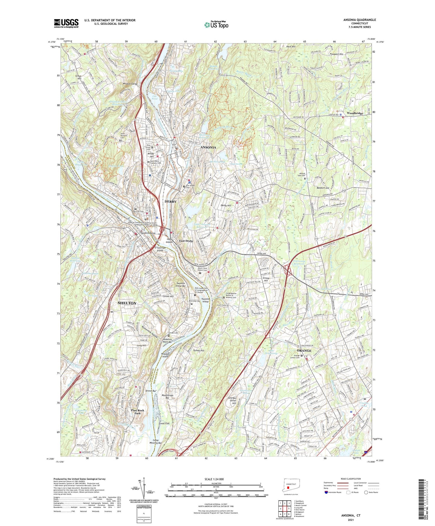
2024 topographic map quadrangle Ansonia in the state of Connecticut. Scale: 1:24000. Based on the newly updated USGS 7.5' US Topo map series, this map is in the following counties: New Haven, Fairfield. The map contains contour data, water features, and other items you are used to seeing on USGS maps, but also has updated roads and other features. This is the next generation of topographic maps. Printed on high-quality waterproof paper with UV fade-resistant inks.
Quads adjacent to this one:
West: Long Hill
Northwest: Southbury
North: Naugatuck
Northeast: Mount Carmel
East: New Haven
Southeast: Woodmont
South: Milford
Southwest: Bridgeport
This map covers the same area as the classic USGS quad with code o41073c1.
Contains the following named places: Abe Stone Park, Amity High School, Amity Regional Junior High School, Anaconda American Brass Company Dam, Ansonia, Ansonia Airfield, Ansonia High School, Ansonia Landing Shopping Center, Ansonia Library, Ansonia Mall Shopping Center, Ansonia Middle School, Ansonia Nature and Recreation Center, Ansonia Plaza Shopping Center, Ansonia Post Office, Ansonia Reservoir, Assumption School, Baird Millpond, Baldwin Hill, Beaver Brook, Beecher Road School, Beth Chana-Hannah Academy, Beth Israel Cemetery of Congregation Or Shalom, Black Brook, B'nail Jacob School, Boy Torah High School, Bradley School, Bristols Ice Pond, Burying Ground Brook, Buttermilk Hollow, Butternut Hollow Brook, Caldor Shopping Center, Camp Cedarcrest, Camp Clark, Camp Meeting Bar, Center School, Charles E Wheeler Wildlife Area, Chordas Pond, City of Ansonia, City of Derby, Clarktown Pond, Coe Pond, Colony Pond, Commodore Hull Intermediate School, Congregation Bethel of Ansonia Cemetery, Coon Hollow Park, Coram Cemetery, Coram Hill, Cranberry Pond, Crosbys Pond, Curtiss Brook, Derby, Derby High School, Derby Hill, Derby Neck Library, Derby Post Office, Derby Public Library, Drews Bar, East Derby, Eisenhower Park, Elm Street Cemetery, Family Health Care Center, Far Mill Park, Farmill River, Ferry School, Firelite Shopping Center, Foundation School, Fountain Lake Dam, Fountain Lake Reservoir, Fowler School, Georges Cellar Hill, Grape Swamp, Grassy Hill, Grassy Hill Country Club, Great Flat, Great Hill, Great Hill Brook, Great Hills Country Club, Griffin Hospital, Griffin Hospital Health Science Library, Hawkins Point, Hawthorne School, Hidelum Rock Bar, High Plains Community Center, High Plains School, Highland Golf Course, Hog Island, Indian Hole Brook, Indian Lake, Irving School, Ivy Brook, Kellogg Environmental Center, Kinneytown, Kinneytown Brook, Kinneytown Dam, Lafayette School, Lake Housatonic, Lake Housatonic Dam, Lake Housatonic Dike, Lake Wepawaug, Larkin School, Laurel Heights State Sanitarium, Lincoln School, Lincoln-Hayes School, Long Hill, Long Hill Cemetery, Long Hill Hospital, Long Hill School, Lower Ansonia Reservoir, Lower Ansonia Reservoir Dam, Mariahs Way Shopping Center, Mary L Tracy School, Mead School, Middle Reservoir, Middle Reservoir Dam, Milford Side Cemetery, Moulthrap Brook, Moulthrops Bar, Mount Saint Peters Cemetery, Naugatuck River, Naugatuck River Reservoir, Nelligan Park, Nolan Field, Nolan School, O' Sullivan Island, Oak Cliff Cemetery, Oak Lane Country Club, Orange, Orange Census Designated Place, Orange Center Cemetery, Orange Center Historic District, Orange Derby Shopping Center, Orange Hills Country Club, Orange Meadows Shopping Center, Orange Post Office, Orange Public Library, Orange Shopping Center, Orange Town Hall, Oronoque Census Designated Place, Oronoque Hills North, Oronoque Village Country Club, Osborndale State Park, Osborne Homestead Museum, Otis House, Parkers Pond, Peat Swamp Reservoir, Peat Swamp Reservoir Dam, Peck Hill, Peck Lane Plaza Shopping Center, Peck Place School, Peck School, Picketts Pond, Picketts Pond Dam, Pin Oak Pond, Pine Grove Cemetery, Pine Rock Park, Pine School, Pink House Cove, Pink House Cove Brook, Plaza on the Green Shopping Center, Plumb Memorial Library, Prospect Hill, Quillinan Reservoir, Quillinan Reservoir Dam, Race Brook, Race Brook County Club, Race Brook School, Red Root Park, Ripton School, River View Country Club, Riverside Cemetery, Riverview Park, Rolling Ridge Commercial Park, Rose Mill Pond, Saint Joseph School, Saint Josephs School, Saint Mary Catholic Cemetery, Saint Marys School, Saint Michaels Cemetery, Saint Michaels School, Shelton, Shelton Fire Chief's Office, Shelton Fire Marshal's Office, Shelton High School, Shelton Lakes Health Care Center, Shelton Post Office, Shelton Reservoir, Shelton Reservoir Number 2 Dam, Shelton Reservoir Number 3 Dam, South Side Plaza Shopping Center, Sow and Pigs Jetty, Spring Lake, Sterling Opera House, Street Memorial Park, Sunnyside, Sunnyside Boat Ramp, Sunnyside Elementary School, Sunnyside Field, Sunnyside Trailer Park, Temple Emanuel Library, Town of Ansonia, Town of Derby, Town of Orange, Town of Woodbridge, Tri-Lake, Tri-Town Plaza Shopping Center, Turkey Hill, Turkey Hill Brook, Turkey Hill School, Twomile Brook, Twomile Island, Twomile Island Bar, Upper Ansonia Reservoir, Upper Ansonia Reservoir Dam, Upper Main Street Historic District, Valley Shopping Center, WADS-AM (Ansonia), Warsaw Park, Wayside Plaza Shopping Center, Wepawaug Reservoir, Wepawaug Reservoir Dam, WHAI-TV (Bridgeport), Wheelers Farm, Wildcat Gorge, Willis School, Windy Hill, WLNV-FM (Derby), Woodbridge, Woodbridge Town Library, Woodside Plaza Shopping Center, Wooster Island, WRXC-FM (Shelton), ZIP Codes: 06401, 06418, 06477, 06525