MyTopo
Long Hill Connecticut US Topo Map
Couldn't load pickup availability
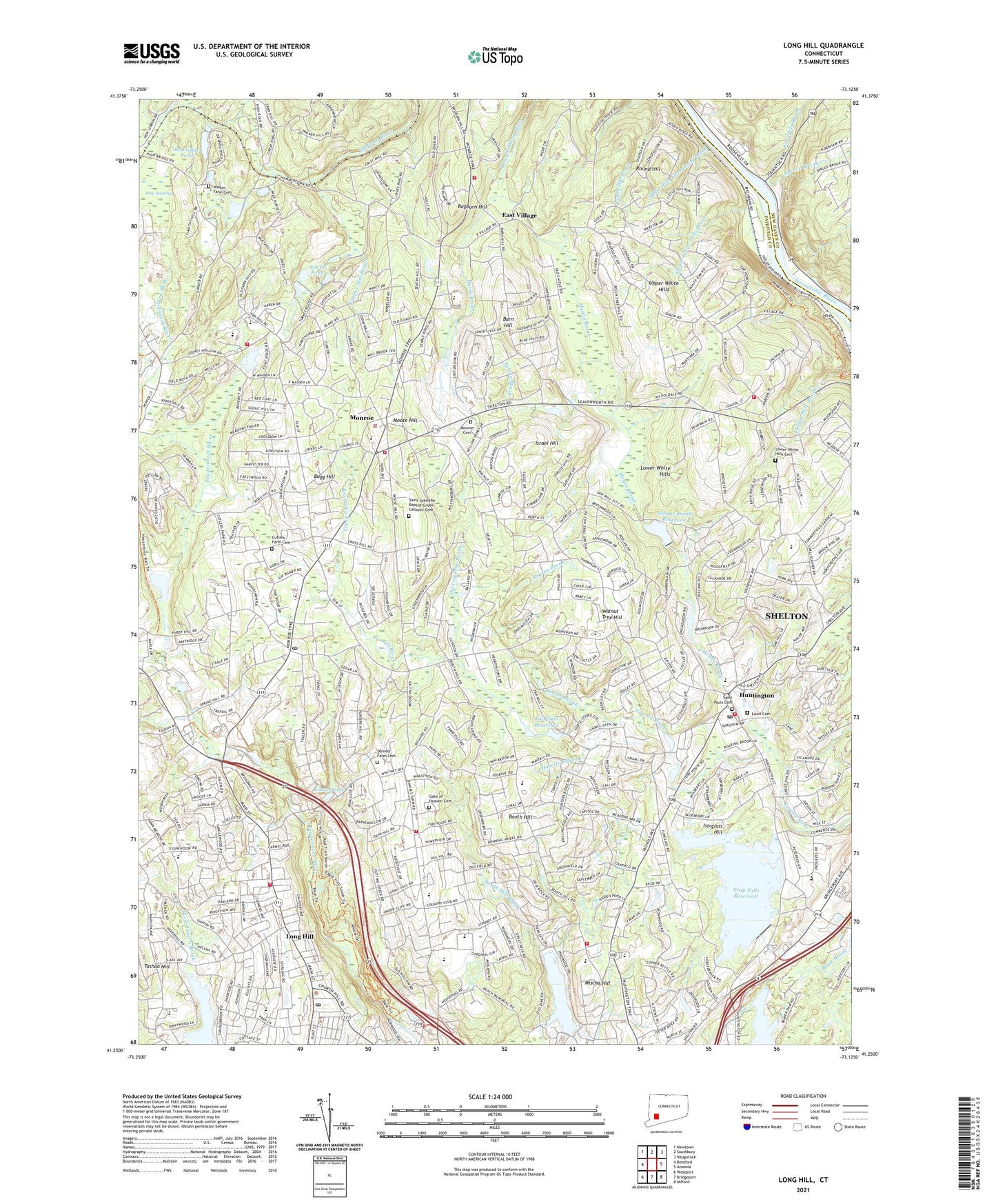
2024 topographic map quadrangle Long Hill in the state of Connecticut. Scale: 1:24000. Based on the newly updated USGS 7.5' US Topo map series, this map is in the following counties: Fairfield, New Haven. The map contains contour data, water features, and other items you are used to seeing on USGS maps, but also has updated roads and other features. This is the next generation of topographic maps. Printed on high-quality waterproof paper with UV fade-resistant inks.
Quads adjacent to this one:
West: Botsford
Northwest: Newtown
North: Southbury
Northeast: Naugatuck
East: Ansonia
Southeast: Milford
South: Bridgeport
Southwest: Westport
This map covers the same area as the classic USGS quad with code o41073c2.
Contains the following named places: Bagburn Hill, Bantam Pond, Bantam Pond Dam, Barn Hill, Beach Memorial Park, Beardsley Brook, Beaver Dam Lake, Belden Brook, Boehm Brook, Booth Hill, Booth Hill School, Brownson Country Club, Bugg Hill, Camp Palmer, Camp Trefoil, Canoe Brook Lake, Chalk Hill Middle School, Church of Christ, City of Shelton, Congregation B'Nai Torah, Copper Mill Brook, Cutlers Farm Cemetery, Daniels Farm Cemetery, Daniels Farm Census Designated Place, Daniels Farm School, East Village, East Village Census Designated Place, East Village Park, Edwards Shopping Center, Elizabeth S Shelton School, Fairchild Heights Trailer Park, Fawn Hollow Elementary School, Fourmile Brook, Gate of Heaven Cemetery, Good Shepherd Lutheran Church, Grace Episcopal Church, Great Oak Park, Halfway River, Harvey Pete Brook, Hazelton Brook, Hillandale Country Club, Hillcrest Middle School, Holy Cross Lutheran Church, Huntington, Huntington Congregational Church, Huntington Fire Company 3, Huntington Historical Society Building, Huntington Plaza Shopping Center, Huntington United Methodist Church, Huntington Village Center Shopping Center, Hurds Brook, Indian Ledge Park, Indian Well State Park, Isinglass Hill, Isinglass Reservoir, Israel Hill, ITT Heliport, Jane Ryan School, Kaatz Pond, Kaatz Pond Dam, Lanes Mine Nature Park, Lawn Cemetery, Long Hill, Long Hill Census Designated Place, Long Hill Fire Department Station 1 Headquarters, Long Hill United Methodist Church, Lower White Hills, Lower White Hills Cemetery, Madison Middle School, Masuk High School, Means Brook, Means Brook Reservoir, Means Brook Reservoir Dam, Mischa Brook Park, Mischa Hill, Mohegan Elementary School, Monroe, Monroe Airport, Monroe Cemetery, Monroe Center Historic District, Monroe Congregational Church, Monroe Elementary School, Monroe Fire Marshal's Office, Monroe Green, Monroe Plaza Shopping Center, Monroe Police Department, Monroe Post Office, Monroe Public Library, Monroe Town Hall, Monroe Volunteer Emergency Medical Services, Monroe Volunteer Fire Department Station 1 Headquarters, Monroe Volunteer Fire Department Station 2, Monroe-Trumbull Regional Alternative High School, Moose Hill, Most Precious Blood School, Nelson Brook, New Convenant Congregational Church, Nichols Fire Station 2, Nichols United Methodist Church, Nike Recreation Fields, North Farrars Brook, Pine Swamp, Pinewood Lake, Pinewood Lake Dam, Roosevelt Forest, Round Hill, Rowledge Pond, Saint John the Baptist Greek Catholic Cemetery, Saint Josephs High School, Saint Josephs Manor, Saint Jude Church, Saint Jude School, Saint Pauls Cemetery, Saint Pauls Episcopal Church, Saint Peters Episcopal Church, Saint Stephens Convent, Saint Stephens School, Sammis Brook, Sharps Brook, Shelton Research Industrial Park, Shelton Square Shopping Center, Smith Pond, Smith Pond Brook, Spruce Brook, Stevenson Volunteer Fire Company Station 2, Tashua Hill, Tashua School, Town Hall Shopping Plaza Shopping Center, Town of Monroe, Town of Shelton, Town of Trumbull, Trap Falls Reservoir, Trap Falls Reservoir Dam, Trumbull Census Designated Place, Trumbull Center Fire Department Station 2, Trumbull Emergency Medical Services, Trumbull Fire Marshal's Office, Trumbull High School, Trumbull Library, Trumbull Post Office, Tungsten Mine Park, Upper White Hills, Upper White Hills Brook, Village Center Shopping Center, Walker Farm Cemetery, Walnut Tree Hill, Webb Mountain Park, WEDW-TV (Bridgeport), West Branch Pequonnock River, WEZN-FM (Bridgeport), White Hill Shopping Center, White Hills, White Hills Church, White Hills Community Brook, White Hills Volunteer Fire Company 5, Whitney Farms Golf Club, William Wolfe Park, WPKN-FM (Bridgeport), WSHU-FM (Fairfield), ZIP Codes: 06468, 06484, 06611