MyTopo
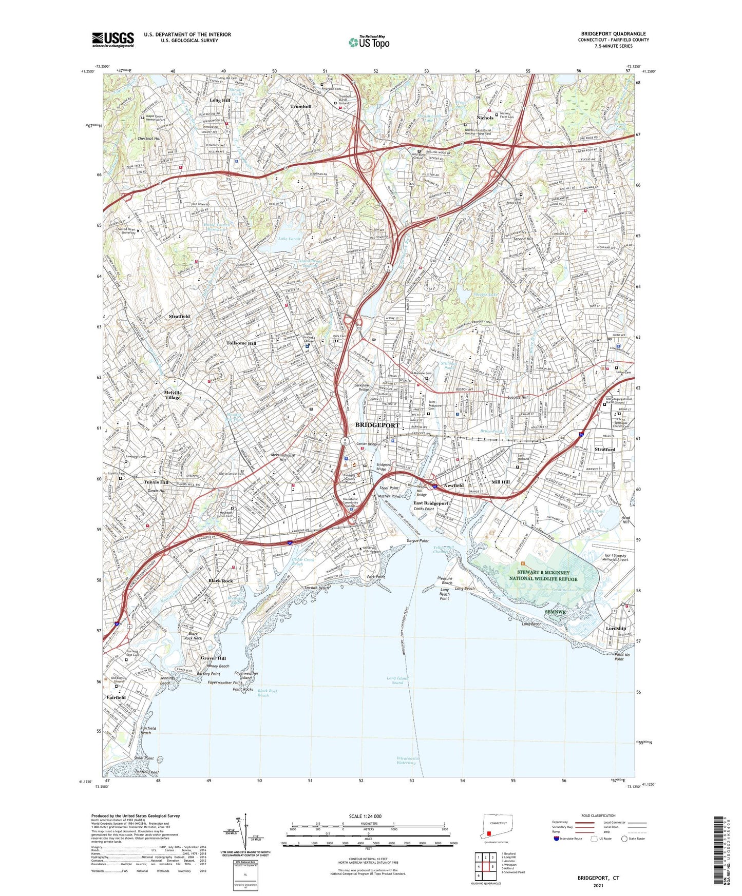
Bridgeport Connecticut US Topo Map
Couldn't load pickup availability
2024 topographic map quadrangle Bridgeport in the state of Connecticut. Scale: 1:24000. Based on the newly updated USGS 7.5' US Topo map series, this map is in the following counties: Fairfield. The map contains contour data, water features, and other items you are used to seeing on USGS maps, but also has updated roads and other features. This is the next generation of topographic maps. Printed on high-quality waterproof paper with UV fade-resistant inks.
Quads adjacent to this one:
West: Westport
Northwest: Botsford
North: Long Hill
Northeast: Ansonia
East: Milford
Southwest: Sherwood Point
This map covers the same area as the classic USGS quad with code o41073b2.
Contains the following named places: Abraham Nichols Park, Academy Hill, Academy Hill Square Shopping Center, Aldo Park, Algonquin Club, Arena At Harbor Yard, Ash Creek, Baldwin Plaza Shopping Center, Ballpark At Harbor Yard, Barnum-Palliser Historic District, Bassickville Historic District, Battery Point, Bayview Shopping Center, Beachwood Park, Beardsley Park, Beardsley Zoological Gardens, Beaver Dam Lake, Beaver Dam Lake Dam, Berkshire Mills, Black Rock, Black Rock Entrance Channel, Black Rock Gardens Historic District, Black Rock Harbor, Black Rock Harbor Number One Light, Black Rock Harbor Number Three Light, Black Rock Historic District, Black Rock Lighthouse, Black Rock Neck, Black Rock Reach, Black Rock Yacht Club, Booth Hill Brook, Boston Industrial Park, Break of the Beach, Breakwater Lighthouse, Brewster Cove, Brewsters Pond, Bridgeport, Bridgeport Downtown North Historic District, Bridgeport Downtown South Historic District, Bridgeport Entrance Channel, Bridgeport Harbor, Bridgeport Harbor Generating Station, Bridgeport Harbor Lighthouse, Bridgeport Hospital Heliport, Bridgeport Station, Brooklawn Country Club, Brookside Shopping Center, Bruce Brook, Bruce Pond, Bunnells Pond, Bunnells Pond Dam, Burr Creek, Burr Creek Marina, Canoe Brook Lake Dam, Canoe Brook Lake Dike, Captains Cove Seaport, Cedar Creek Reach, Cemetery Pond Brook, Chamberland Pond, Chase Manhattan Bank of Connecticut Heliport, Chestnut Hill, City Hall Park, City of Bridgeport, Clinton Park, Clover Field, Cooks Point, Cooks Pond, Crossway Mall Shopping Center, Cupheag, Davidow Park, East Breakwater Light, East Bridgeport, East Bridgeport Historic District, East End Freight Yards, East End Yacht Club, East Main Street Historic District, Eastside Park, Ehrsam Pond, Elton Rogers Woodland Park, Fairchild Memorial Park, Fairchild Wheeler Golf Course, Fairchild-Wheeler Park, Fairfield Beach, Fayerweather Island, Fayerweather Point, Forest Lake Dam, Frash Pond, Frog Pond, Gateway Village Historic District, Glenwood Park, Golden Hill Historic District, Gould Manor Park, Grand Central Shopping Center, Great Meadows, Grover Hill, Hard Corner, Hawley Lane Shopping Center, High Park, Hi-Ho Center Shopping Mall Shopping Center, Hill Side Home, Horse Tavern Brook, Horse Tavern Reservoir, Igor I Sikorsky Memorial Airport, Island Brook, Island Brook Lagoon, Island Brook Lagoon Dam, Island Brook Park, Jennings Beach, Johnson Oak Park, Johnsons Creek, Kennedy Stadium, Lafayett Park, Lafayette Shopping Plaza Shopping Center, Lake Forest, Lakeview Cemetery, Lakeview Village Historic District, Lawncroft Cemetery, Lewis Gut, Lilalyn Park, Little Danbury, Londons Brook, Long Beach, Long Beach Point, Long Brook, Long Hill Cemetery, Longfellow Park, Low Park, Loyalty Cemetery, Maefair Court, Marina Park Historic District, Marina Village, Mather Dock, Mather Point, McClevy Green, Medical Center Heliport, Meetinghouse Hill, Melville Village, Middlebrooks Park, Mill Hill, Money Beach, Moodys Mill Pond, Mountain Grove Cemetery, Newfield, Newfield Park, Nichols, Nichols Farm Cemetery, Nichols Farm Historic District, Ninety Acres Park, North End Park, North Parade Ground, Nothinagle Memorial Field, Old Mill Green, Old Stratfield Cemetery, Ox Hill, Paradise Green Park, Park Cemetery, Park Point, Park Square, Penfield Reef, Pequonnock River, Pixlee Tavern, Pleasure Beach, Pleasure Beach Park, Point No Point, Point Rocks, Remington City Historic District, Remington Village Historic District, Riverside Cemetery, Rooster River, Sacred Heart University Census Designated Place, Schoonhoven Park, Seaside Beach, Seaside Park, Seaside Village Historic District, Second Hill, Seeleys Pond, Shoal Point, Shoppers Plaza Shopping Center, Shoreline Star Greyhound Park and Entertainment Complex, Sikorsky Bridgeport Heliport, South Benson Marina, Steel Point, Sterling Park, Stewart B McKinney National Wildlife Refuge, Stillman Pond, Stratfield, Stratford, Stratford Census Designated Place, Stratford Center Historic District, Stratford Downtown Census Designated Place, Stratford Square Shopping Center, Stratford Station, Success Hill, Success Lake, Success Lake Dam, Success Park, Svihra Park, Three Thousand Three Hundred and Fifty Five Shopping Plaza, Thrushwood Lake, Toilsome Hill, Tongue Point, Tongue Point Breakwater, Tongue Point Lighthouse, Town of Bridgeport, Town of Stratford, Trumbull, Trumbull Burial Ground, Trumbull Center Census Designated Place, Trumbull Center Shopping Center, Trumbull Park Business Center Shopping Center, Trumbull Shopping Center, Trumbull Shopping Park Shopping Center, Tunxis Hill, Tunxis Hill Park, Tunxis Hill Shopping Center, Twin Brooks Park, Veterans Park, Washington Park, Water View Park, Went Field, West Side Park, Westfield Shopping Park Shopping Center, White Rock Creek, Wooster Park, Yellow Mill Channel, YMCA Park, ZIP Codes: 06604, 06605, 06606, 06607, 06608, 06610, 06614, 06615, 06825