MyTopo
Palmertown Connecticut US Topo Map
Couldn't load pickup availability
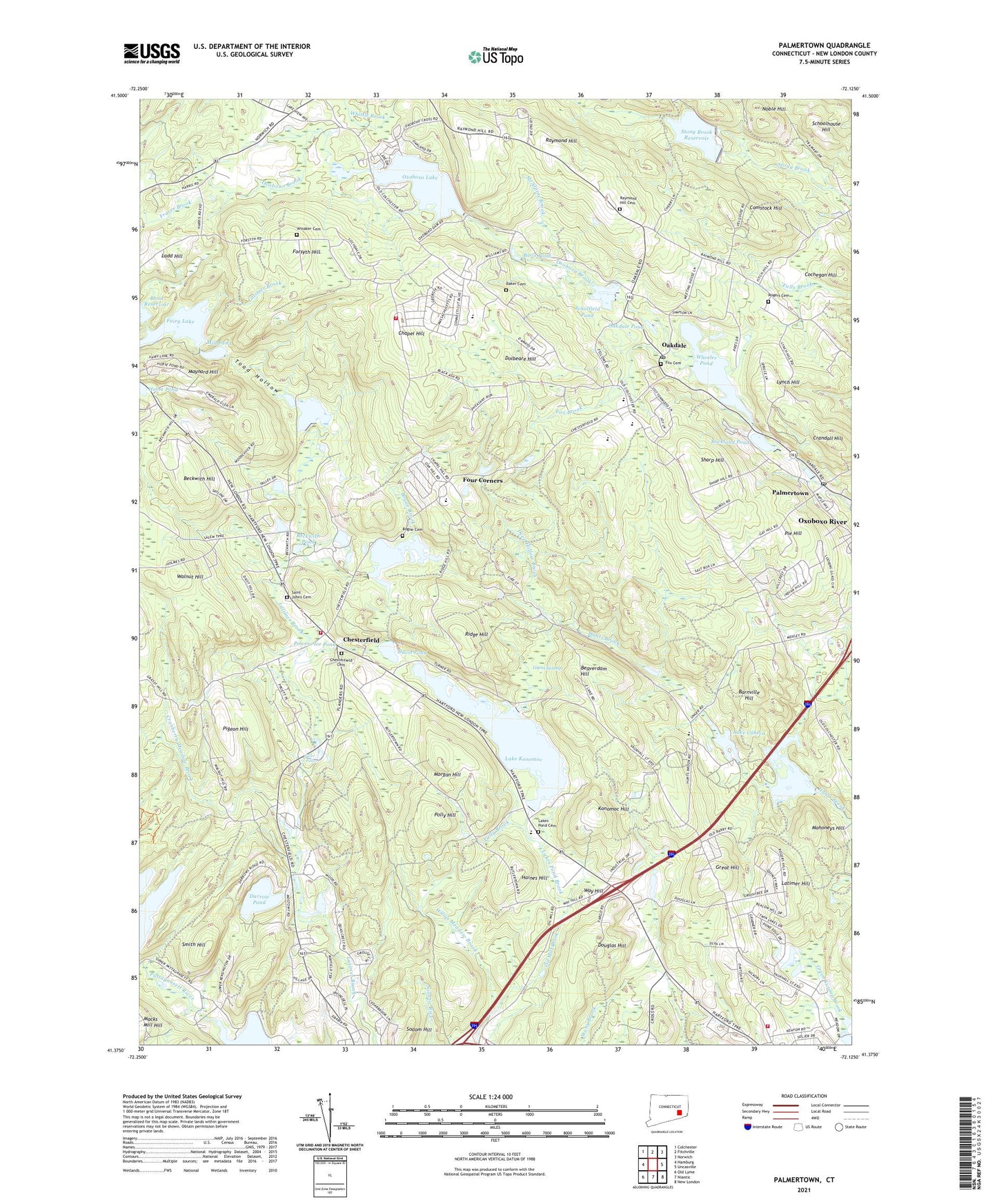
2024 topographic map quadrangle Palmertown in the state of Connecticut. Scale: 1:24000. Based on the newly updated USGS 7.5' US Topo map series, this map is in the following counties: New London. The map contains contour data, water features, and other items you are used to seeing on USGS maps, but also has updated roads and other features. This is the next generation of topographic maps. Printed on high-quality waterproof paper with UV fade-resistant inks.
Quads adjacent to this one:
West: Hamburg
Northwest: Colchester
North: Fitchville
Northeast: Norwich
East: Uncasville
Southeast: New London
South: Niantic
Southwest: Old Lyme
Contains the following named places: Baker Cemetery, Baptist Bible Academy, Barnes Reservoir, Barnes Reservoir Dam, Barnville Hill, Beaverdam Hill, Beckwith Hill, Beckwith Pond, Bogue Brook, Bogue Brook Reservoir, Bogue Brook Reservoir Dam, Bogue Cemetery, Calvary Christian Fellowship Church, Camp Oakland, Camp Waterford, Cedar Ridge Golf Course, Chapel Hill, Chapel Hill School, Chesterfield, Chesterfield Cemetery, Chesterfield Fire Company, Cochegan Hill, Cohanzie Elementary School, Cohanzie Fire Department Station 5, Cohanzie Park, Collins School, Comstock Hill, Country Club of New England, Cranberry Meadow Brook, Crandall Hill, Darrow Pond, Darrow Pond Dam, Davis Pond, Deep Hollow Brook, Doctor Charles E Murphy School, Dolbeare Hill, Douglas Hill, Fairy Lake, Fairy Lake Dam, Forsyth Hill, Four Corners, Fox Brook, Fox Cemetery, Great Hill, Great Swamp, Green Swamp Brook, Haines Hill, Konomoc Hill, Ladd Hill, Lake Cuheca, Lake Konomoc, Lake Konomoc Dam, Lakes Pond Brook, Lakes Pond Cemetery, Lakes Pond Church, Latimer Hill, Leary Park, Leonard J Tyl Middle School, Lyman Allen Park, Lynch Hill, Mahoneys Hill, Manwaring School, Maynard Hill, McAlpine Brook, Mill Pond, Miller Pond, Miller Pond Dam, Montville Center, Montville Center Congregational Church, Montville Post Office, Morgan Hill, Noble Hill, Oakdale, Oakdale Baptist Church, Oakdale Fire Company Station 4, Oakdale Pond, Oakdale Post Office, Old Barry Farm, Oxoboxo Lake, Oxoboxo Lake Dam, Oxoboxo River Census Designated Place, Palmer School, Palmertown, Paris Pond, Pie Hill, Pigeon Hill, Polly Brook, Polly Hill, Pond School, Powers Brook, Powers Ice Pond, Raymond Hill, Raymond Hill Cemetery, Red Mill Pond, Ridge Hill, Rockland Pond, Rockland Pond Dam, Rogers Cemetery, Saint Johns Cemetery, Schofield Pond Dam, Scholfield Pond, Schoolhouse Hill, Sharp Hill, Silver Falls, Smith Hill, Sportsman Club, Stony Brook Reservoir, Stony Brook Reservoir Dam, Toad Hollow, Town of Montville, Tyler Middle School, United Church of Christ, Vauxhall Park, Walnut Hill, Waterford Country School, Waterford Industrial Triangle Park, Waterford Municipal Complex, Waterford Speedbowl, Way Hill, West Side School, Wheeler Pond, Wheeler Pond Dam, Willys Meadow Brook, Winaker Cemetery, WNLC-AM (New London), WTWS-TV (New London), WTYD-FM (New London), ZIP Codes: 06333, 06353, 06370