MyTopo
Uncasville Connecticut US Topo Map
Couldn't load pickup availability
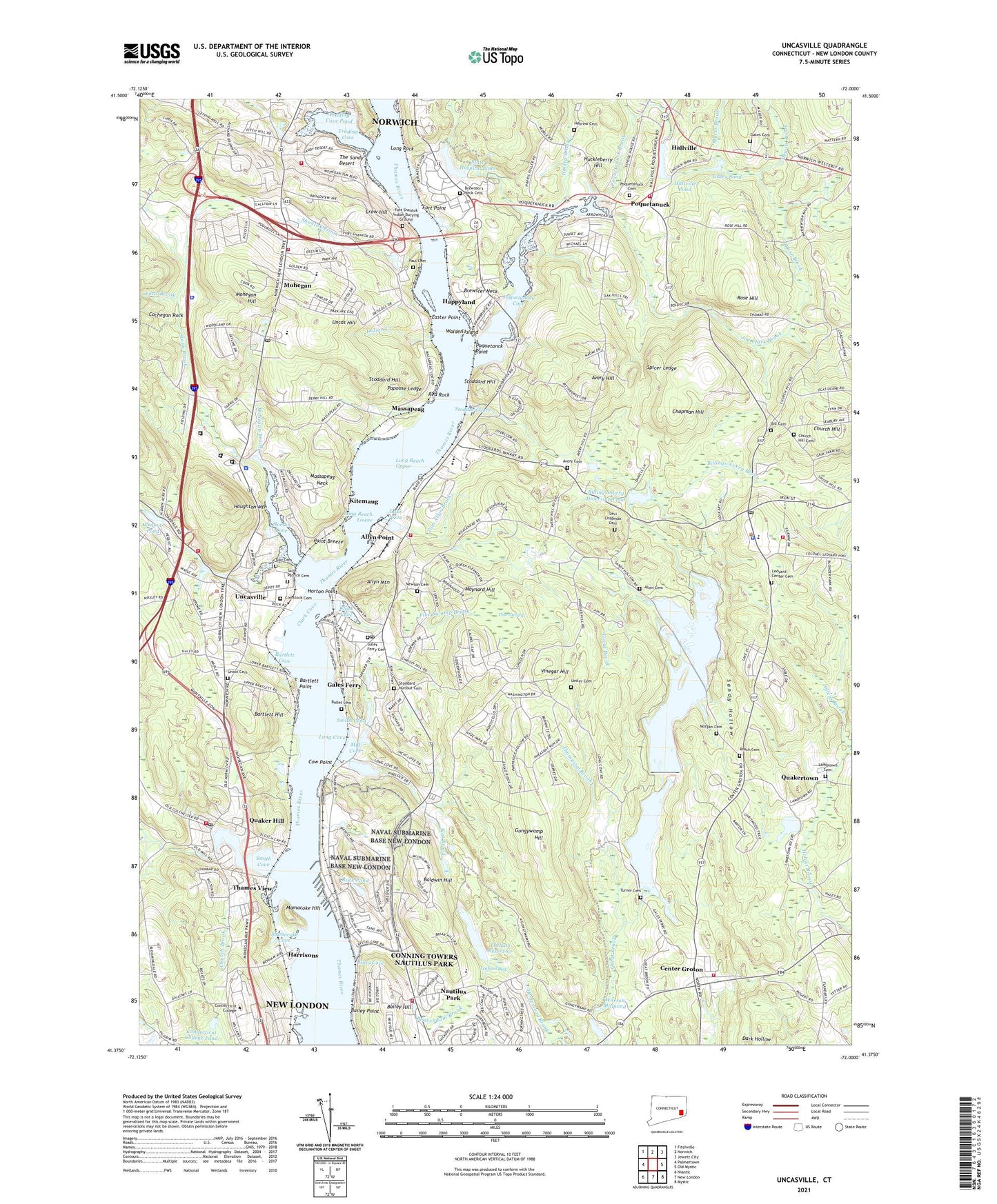
2024 topographic map quadrangle Uncasville in the state of Connecticut. Scale: 1:24000. Based on the newly updated USGS 7.5' US Topo map series, this map is in the following counties: New London. The map contains contour data, water features, and other items you are used to seeing on USGS maps, but also has updated roads and other features. This is the next generation of topographic maps. Printed on high-quality waterproof paper with UV fade-resistant inks.
Quads adjacent to this one:
West: Palmertown
Northwest: Fitchville
North: Norwich
Northeast: Jewett City
East: Old Mystic
Southeast: Mystic
South: New London
Southwest: Niantic
This map covers the same area as the classic USGS quad with code o41072d1.
Contains the following named places: Allen Cemetery, Allyn Mountain, Allyn Point, Avery Cemetery, Avery Hill, Bailey Hill, Bailey Point, Baldwin Hill, Bartlett, Bartlett Corners, Bartlett Cove, Bartlett Hill, Bartlett Point, Beaverdam Brook, Best View, Bill Cemetery, Billard Hall, Billings Avery Brook, Billings Avery Diversion Pond, Billings Avery Diversion Pond Dam, Bolles Cemetery, Brewster Neck, Brewster's Neck Cemetery, Cabot Memorial Field, Center Groton, Center Groton Park, Ceravolo Sub Park, Chapman Hill, Charles Barnum Elementary School, Church Brook, Church Hill, Church Hill Cemetery, Clark Cove, Cochegan Rock, Colonel Ledyard Park, Comstock Cemetery, Congdon Dam, Connecticut College, Connecticut College Arboretum, Connecticut College Pond, Conning Towers Nautilus Park Census Designated Place, Copp Park, Cow Point, Crew Rowing Center, Crow Hill, Crowley Brook, Eagle Pier, Easter Point, Ed Lamb Brook, Falls Brook, Fitch Corner, Flat Brook, Fort Decatur, Fort Hill, Fort Point, Fort Shantok Indian Burying Ground, Four Corners, Gales Ferry, Gales Ferry and Bill Library, Gales Ferry Cemetery, Gales Ferry Census Designated Place, Gales Ferry Post Office, Gales Ferry School, Gates Cemetery, Gates Pond, Gay Cemetery, Gay Cemetery Pond, Gay Cemetery Pond Dam, Geer Hill School, Goss Cove, Grange Hall, Gray Rock Parket, Gungywamp Hill, Haley Woods Park, Hallville, Hallville Pond, Hallville Pond Dam, Halsey Brook, Happyland, Harrisons, Harvard Boathouse, Haughton Mountain, Hebrew Cemetery, Hewitt Brook, Horton Cove, Horton Point, Huckleberry Hill, Hunts Brook, Indian Creek, Indian Hill Light, Jacobs Rock Sailing and Semanship Center, Joe Clark Brook, Johnson Hall, Johnson Pond, Johnson Pond Dam, Juliet W Long School, Kitemaug, Lake Nova, Lake Nova Dam, Lambstown School, Lambtown Cemetery, Latham Bog, Latham Reservoir, Ledyard Center, Ledyard Center Cemetery, Ledyard Center School, Ledyard Center Shopping Center, Ledyard Library, Ledyard Middle School, Ledyard Post Office, Ledyard Reservoir, Ledyard Reservoir Dam, Lester Cemetery, Levi Chapman Cemetery, Liberty Square, Long Cove, Long Reach Lower, Long Reach Upper, Long Rock, Long Rock Dike, Lyman Allyn Art Museum Library, Lyman Allyn Museum of Art, Mamacoke Cove, Mamacoke Hill, Massapeag, Massapeag Neck, Maushantuxet, Maynard Hill, McAllister Hall, Meredith Hill Park, Michel Hall, Mill Cove, Mohegan, Mohegan Brook, Mohegan Hill, Mohegan Reservation, Mohegan School, Montville Alternate Education Center, Montville Station, Morgan Cemetery, Morgan Pond, Morgan Pond Dam, Morgan Pond Reservoir, Myers Brook, Nathan Lester House, Nautilus Park, Naval Submarine Base New London, Naval Undersea Warfare Center-Detachment Technical Library, New London County, New London County Home, Newton Cemetery, Norwich State Hospital, Officers Row, Old Indian Fort, Oxoboro Brook Reservoir, Oxoboxo Brook, Papoose Ledge, Paul Cemetery, Pequot Pond, Phoenix Drive Park, Pine Swamp, Pine Swamp Brook, Pleasant Valley Elementary School, Point Breeze, Poquetanck Point, Poquetanuck, Poquetanuck Brook, Poquetanuck Cemetery, Poquetanuck Cove, Poquetanuck Elementary School, Quaker Hill, Quaker Hill Elementary School, Quaker Hill Post Office, Quakertown, Radgowski Annex, Red Rock, Riverside Village Mall Shopping Center, Roach Cemetery, Robert Crown Park, Rock Pond, Romanella Subdivision Park, Rose Brook, Rose Hill, Rosemond Lake, Saint Patrick Cemetery, Sandy Hollow, SCRRRA Industrial Park, Shantok Brook, Shewville Brook, Smith Cove, Smith Pond, Spicer Ledge, State Hospital Pond, Stoddard - Hurlbut Cemetery, Stoddard Cove, Stoddard Hill, Stoddard Hill State Park, Stoddard Landing, Stony Brook, Thames View, The Ledyard Oak, The Sandy Desert, Thompson Brook, Tom Allyn Brook, Town of Ledyard, Trading Cove, Trading Cove Brook, Trading Cove Dike, Trading Cove Pond, Trading Cove Pond Dam, Trident Park, Turner Cemetery, Uncas Hill, Uncasville, Uncasville Post Office, Union Cemetery, Unionville School, United States Coast Guard Academy Main Gate, USS Nautilus Memorial, Vinegar Hill, Walden Island, Warren Millpond, Waterford Little League Field North, Watrous Park, WCNI-FM (New London), WCTY-FM (Norwich), William School, WQGN-FM (Groton), WSUB-AM (Groton), Yale Boathouse, YMCA Pond, YMCA Pond Dam, ZIP Codes: 06335, 06375, 06382