MyTopo
Fitchville Connecticut US Topo Map
Couldn't load pickup availability
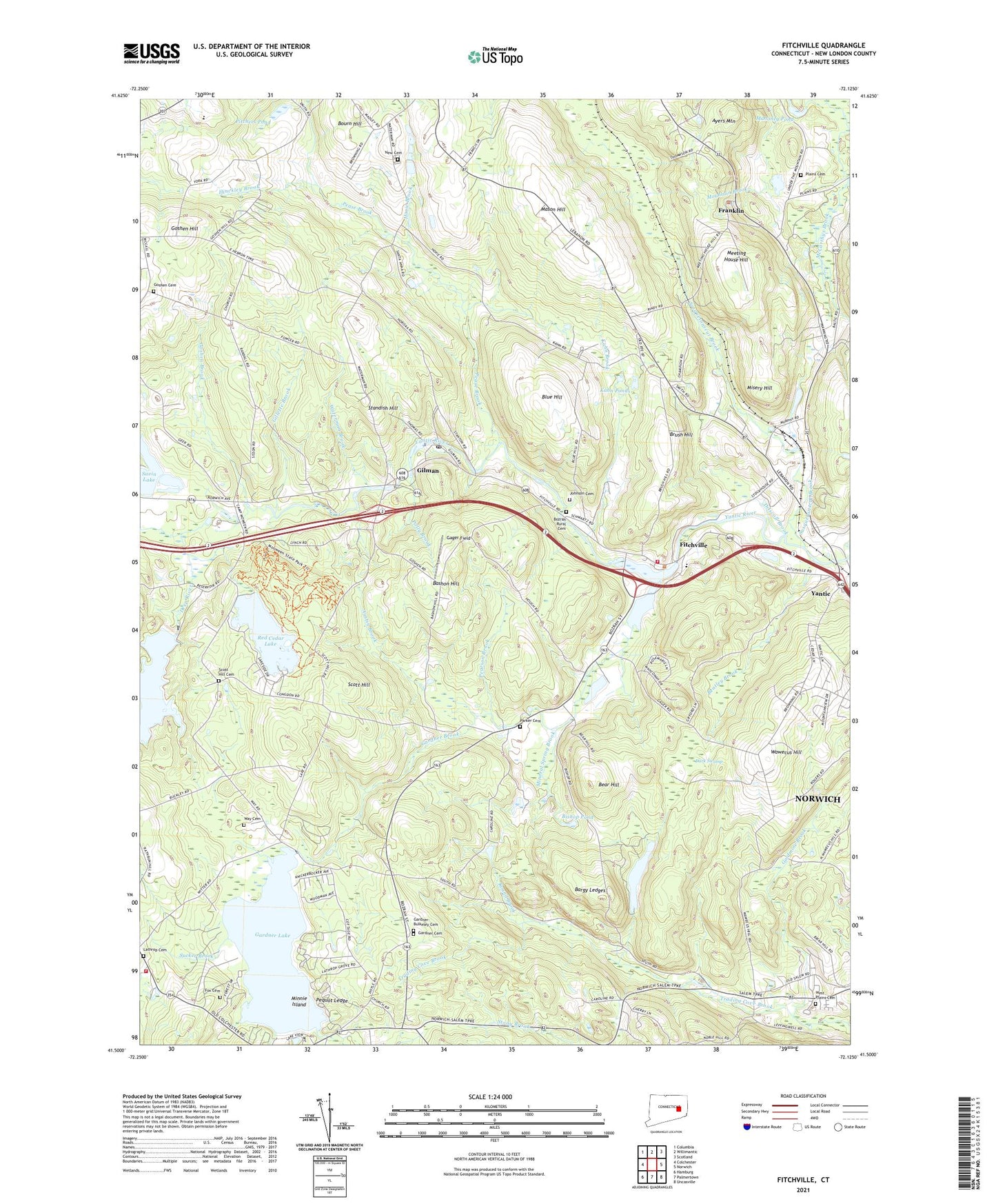
2024 topographic map quadrangle Fitchville in the state of Connecticut. Scale: 1:24000. Based on the newly updated USGS 7.5' US Topo map series, this map is in the following counties: New London. The map contains contour data, water features, and other items you are used to seeing on USGS maps, but also has updated roads and other features. This is the next generation of topographic maps. Printed on high-quality waterproof paper with UV fade-resistant inks.
Quads adjacent to this one:
West: Colchester
Northwest: Columbia
North: Willimantic
Northeast: Scotland
East: Norwich
Southeast: Uncasville
South: Palmertown
Southwest: Hamburg
This map covers the same area as the classic USGS quad with code o41072e2.
Contains the following named places: Austin Brook, Avery Corner, Ayers Mountain, Bargy Ledges, Bargytown, Bashon Hill, Bear Hill, Bentley Brook, Birchard Plain, Bishop Pond, Blue Hill, Blue Slope Country Museum, Bourn Hill, Bozrah Center Congregational Church, Bozrah Rural Cemetery, Bozrah Street, Bozrah Town Hall, Bozrah Volunteer Fire Company Station 26, Brush Hill, Camp Cadaho Tohaci, Camp Juanita Adajuan, Camp Mooween, Camp Odetah, Camp Tadma, Camp Trupin, Camp Wakenah, Camp Wetonaw, Camp Winnapaw, Camp Winnepaw, Dark Swamp, Deep River, Deep River Reservoir Dam, Driscoll Brook, Fernwood Playground, Fields Memorial Elementary School, Fitchville, Fitchville Baptist Church, Fitchville Pond, Fitchville Pond Dam, Four-H Club Camp, Fox Cemetery, Franklin, Franklin Congregational Church, Franklin Station, Franklin Town Hall, Gager Field, Gardner Brook, Gardner Cemetery, Gardner Lake, Gardner Lake Airport, Gardner Lake Dam, Gardner Lake Park, Gardner Lake Volunteer Fire Company Station 27, Gardner-Bulkeley Cemetery, Gillette Brook, Gilman, Gilman Pond, Gilman Post Office, Goldmine Brook, Goshen Brook, Goshen Cemetery, Goshen Church, Goshen Hill, Hinckley Brook, Hopemead State Park, Hoxie Brook, Johnnycake Brook, Johnson Cemetery, Kahn Brook, Kahn Ponds, Lake Marie, Lake Marie Dam, Lathrop Cemetery, Lebanon Country Club, Lebanon Road School, Leffingwell, Leffingwell Baptist Church, Leffingwell School, Mahoney Pond, Mason Hill, McGrath Dam, Meeting House Hill, Mineral Spring Brook, Minnie Island, Minnie Island State Park, Misery Hill, New Cemetery, Our Lady of Lakes Church, Parker Cemetery, Paugwaunk Church, Pearson Brook, Pease Brook, Pequot Ledge, Pitchers Pond, Plains Cemetery, Polly Brook, Red Cedar Lake, Red Cedar Lake Dam, Round Brook, Savin Lake, Savin Lake Dam, Scott Hill, Scott Hill Cemetery, Seymour Gravel Pit, Sherman Brook, Smith Corner, Standish Hill, Sucker Brook, Susquetonscut Brook, Tadma Pond, Tadma Pond Dam, Town of Bozrah, Town of Franklin, Waterman Brook, Wawecus Hill, Way Cemetery, WEDN-TV (Norwich), West Plains Cemetery, Whittle Brook, WNPR-FM (Norwich), Yantic River Dam, ZIP Codes: 06254, 06334, 06336, 06389