MyTopo
Southington Connecticut US Topo Map
Couldn't load pickup availability
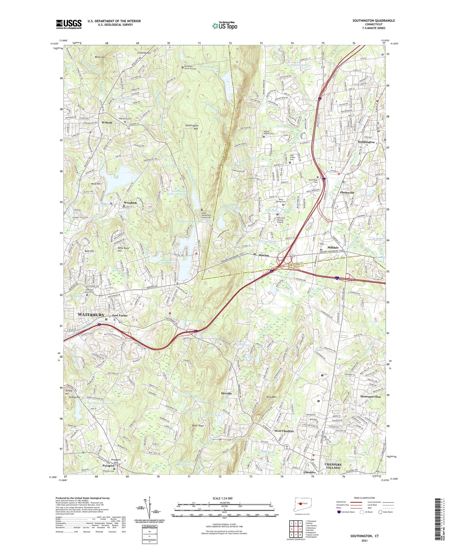
2024 topographic map quadrangle Southington in the state of Connecticut. Scale: 1:24000. Based on the newly updated USGS 7.5' US Topo map series, this map is in the following counties: New Haven, Hartford. The map contains contour data, water features, and other items you are used to seeing on USGS maps, but also has updated roads and other features. This is the next generation of topographic maps. Printed on high-quality waterproof paper with UV fade-resistant inks.
Quads adjacent to this one:
West: Waterbury
Northwest: Thomaston
North: Bristol
Northeast: New Britain
East: Meriden
Southeast: Wallingford
South: Mount Carmel
Southwest: Naugatuck
This map covers the same area as the classic USGS quad with code o41072e8.
Contains the following named places: Alcott Middle School, All Saints Episcopal Church, Bald Hill, Becar Hill, Beecher Street School, Bergin Education Complex, Black Pond, Bluff Head, Bradley Barnes Museum, Break Hill Brook, Brooks Pond, Burke Heliport, Burritt Street Park, Campion Ambulance Service, Central Baptist Church, Chapman School, Chase Country Club, Cheshire Academy, Cheshire Correctional Institution, Cheshire Fire Department Company 2, Cheshire Fire Department Headquarters, Cheshire Golf Course, Cheshire Industrial Park, Cheshire Landfill Area, Cheshire Police Department, Cheshire Post Office, Cheshire Reservoir, Cheshire Reservoir Dam, Cheshire Shopping Center, Cheshire Town Park, Cheshire Village Census Designated Place, Church of the Epiphany, Clintons Pond, Confield Park, Cornelis Dam, Cornelis Pond, Cornerstone Church, Crosby High School, Cuff Brook, Darcey Early Intervention School, Dayton Brook, Deaconwood, Dodd Middle School, East Farms, East Farms Cemetery, East Farms School, Edgewood Cemetery, Eightmile River, Eightmile River State Access Area, Evers Pond, Finch Brook, First Congregational Church, First Lutheran Church, Florians Pond, Fox Hollow, Frisbie School, Frost Road Pond, Grace Baptist Church, Greater Southington Chamber of Commerce, Highland School, Hitchcock Lake, Hitchcock Lake Brook, Hitchcock Lake Dam, Holcomb School, Holy Trinity Cemetery, Holy Trinity Polish Catholic Church, Honeypot Brook, Honeypot Glen, Hotchkiss Field, Hotchkiss House, Humiston Brook, Immaculate Conception Church, John F Kennedy Middle School, Judd Brook, Kiwanis Easter Seal Day Camp, LaCourse Pond, Larsens Pond, Lily Brook, Lindsley Brook, Lindsley Hill, Long River Middle School, Lutheran Church of Cheshire, Manson Youth Correctional Institution, Manson Youth Institution, Marion, Marion Historic District, Marion Post Office, Mary F Rotella School, Mattatuck Trail, McGrath Park, Merriman Burying Ground, Milldale, Milldale Post Office, Misery Brook, Mixville, Mixville Park, Mixville Pond, Mixville Pond Dam, Moss Farms Pond, Moss Farms Pond Dam, Mount Southington Ski Area, Mount Vernon Cemetery, Mountain Brook, New Britain Reservoir, New Britain Reservoir Dam, New Britain Reservoir Dike, New Pine Grove Cemetery, North Branch Hamlin Brook, North Center School, Northeast Burial Ground, Old Tannery Brook, Panthorne Park, Park Pond, Peck Mountain, Peterson Park, Plants Pond, Plantsville, Plantsville Census Designated Place, Plantsville Congregational Church, Plantsville Historic District, Plantsville Post Office, Plantsville School, Pratt and Whitney Heliport, Prospect, Prospect Cemetery, Prospect Community Elementary School, Prospect Congregational Church, Prospect Hill, Prospect Public Library, Prospect Town Garage, Quinnipiac Cemetery, Quinnipiac River Public Access, Quinnipiac River State Access Area, Roaring Brook, Saint Aloysius Church, Saint Bridgets Church, Saint Bridgets School, Saint Leo the Great Church, Saint Maria Goretti Church, Saint Pauls Episcopal Church, Saint Puis X Church, Saint Thomas Church, Saint Thomas School, Scott Road Park, Scovill Reservoir, Seventh Day Adventist Church, Sloping Acres Playground, Smith Elementary School Cemetery, South Branch Hamlin Brook, South End School, Southington, Southington Center Historic District, Southington Fire Department Engine Company 1, Southington Fire Department Engine Company 2, Southington Fire Department Engine Company 3, Southington Mountain, Southington Police Department, Southington Post Office, Southington Public Library, Southington Reservoir Number 1, Southington Reservoir Number 2, Southington Reservoir Number 2 Dam, Southington Reservoir Number 3, Southington Reservoir Number 3 Dam, Southington Reservoir Number 3 Dike, Southington Town Hall, Southwest District School, Strong Elementary School, Tame Buck Hill, Tenmile River, The Hospital of Central Connecticut Bradley Memorial Campus, The Meeting Place, Theriaults Ice Pond, Town Hall Field, Town of Cheshire, Town of Southington, Town of Wolcott, Turkey Hill, Tyrrell School, United Church of Christ Library, Waterbury Reservoir Number 2, Waterbury Reservoir Number 2 Dam, Webster Correctional Institution, West Brook, West Brook Reservoir, West Cheshire, West Ridge School, West Street School, Willowbrook Farms, WNTY-AM (Southington), Wolcott, Wolcott Community Bible Church, Wolcott Congregational Church, Wolcott Fire Chief's Office, Wolcott High School, Wolcott Plaza Shopping Center, Wolcott Police Department, Wolcott Public Library, Wolcott Volunteer Ambulance Association, Wolcott Volunteer Fire Department Company 1, Wolcott Volunteer Fire Department Company 3, Wolf Hill, Wonx Spring Cemetery, Woodtick, Woodtick Cemetery, Woodtick Reservoir, Woodtick Reservoir Dam, Woodtick Reservoir Dike, ZIP Codes: 06410, 06444, 06467, 06479, 06705, 06716


