MyTopo
Thomaston Connecticut US Topo Map
Couldn't load pickup availability
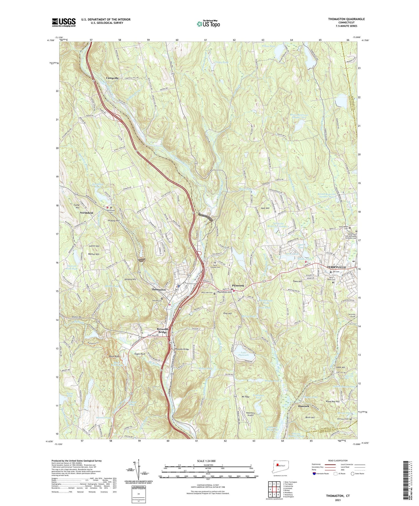
2024 topographic map quadrangle Thomaston in the state of Connecticut. Scale: 1:24000. Based on the newly updated USGS 7.5' US Topo map series, this map is in the following counties: Litchfield, Hartford, New Haven. The map contains contour data, water features, and other items you are used to seeing on USGS maps, but also has updated roads and other features. This is the next generation of topographic maps. Printed on high-quality waterproof paper with UV fade-resistant inks.
Quads adjacent to this one:
West: Litchfield
Northwest: West Torrington
North: Torrington
Northeast: Collinsville
East: Bristol
Southeast: Southington
South: Waterbury
Southwest: Woodbury
This map covers the same area as the classic USGS quad with code o41073f1.
Contains the following named places: Allentown Cemetery, Alternative Community Education School, Birch Hill, Birdsall Pond, Black Rock, Black Rock Dam, Black Rock Lake, Black Rock Pond, Black Rock Pond Dam, Black Rock School, Black Rock State Park, Branch Brook, Branch Brook Campground, Bristol Reservoir Number 2 Dam, Bristol Reservoir Number 4, Bristol Reservoir Number 4 Dam, Bristol Reservoir Number 5 Dam, Bristol Reservoir Number Five, Bristol Reservoir Number Three, Bristol Reservoir Number Two, Brophy Pond, Brophy Pond Dam, Buttermilk Falls, Camp Hill, Camp Mattatuck, Campville, Covenant Church, Crestbrook Country Club, Eagle Rock, Eagle Rock Church, First Baptist Church, Gilbert Library, Hancock, Hancock Brook Lake, Hannon Pond, Harry S Fisher School, Hickory Hill, Hillside Cemetery, Holt Hill, Holt School, Humaston Brook, Humaston Brook State Park, Immaculate Conception Roman Catholic Church, Jefferson Hill Brook, Jericho Brook, Lake Plymouth, Lake Plymouth Dam, Lane Hill, Lattin Hill, Leadmine Brook, Lock Museum of America, Lock Museum of America Library, Lockwood Pond, Lockwood Pond Dam, Main Street School, Marino Pond, Marsh Brook, Masterbone Pond, Mattatuck State Forest, McCoy Pond, Merriman Pond, Meyers Pond, Middle Pond, Middle Pond Dam, Minor Pond, Morton Pond, Mount Tobe, Nibbling Brook, Northfield, Northfield Brook, Northfield Brook Dam, Northfield Brook Lake, Northfield Cemetery, Northfield Congregational Church, Northfield Heliport, Northfield Pond, Northfield Pond Dam, Northfield Volunteer Fire Company, Nystrom Park, Nystrom Pond Dam, Nystrom Pond State, Old Cemetery, Pine Hill, Plymouth, Plymouth Ambulance Service, Plymouth Center Elementary School, Plymouth Congregational Church, Plymouth Green, Plymouth Hill, Plymouth Historical Society Building, Plymouth Library Association, Plymouth Post Office, Plymouth Reservoir, Plymouth Reservoir Dam, Plymouth Town Hall, Plymouth Volunteer Ambulance Corps, Poland River, Pratt Pond, Prospect Street School, Pudding Brook, Purgatory Brook, Reynolds Bridge, Rock Brook, Roraback Lodge, Saint Johns Cemetery, Saint Marys Cemetery, Saint Thomas Cemetery, Saints Cyril and Methodius Orthodox Cemetery, Smith Pond, Smith Pond Dam, Spruce Brook, Sutliffe Brook, Terryville, Terryville Census Designated Place, Terryville High School, Terryville Reservoir Number 2, Terryville Reservoir Number 3, Terryville Reservoir Number 3 Dam, Terryville Volunteer Fire Department Headquarters, Terryville Volunteer Fire Department Station 2, Thomaston, Thomaston Census Designated Place, Thomaston Dam, Thomaston Police Department, Thomaston Volunteer Ambulance Corps, Thomaston Volunteer Fire Department, Todd Hollow Brook, Tolles, Tomlinson Pond, Tomlinson Pond Dam, Town Hill, Town of Plymouth, Town of Thomaston, Turner Brook, Upper Pond, Upper Pond Dam, Valley Pond, Valley Pond Dam, Walnut Hill, Waterbury Airport, West Side Cemetery, Wilson Pond, Wilson Pond Dam, Wilton Pond, Wilton Pond Dam, Wood Key Hill, Zeiner Pond, Zeiner Pond Dam, ZIP Codes: 06778, 06782, 06786, 06787