MyTopo
New Britain Connecticut US Topo Map
Couldn't load pickup availability
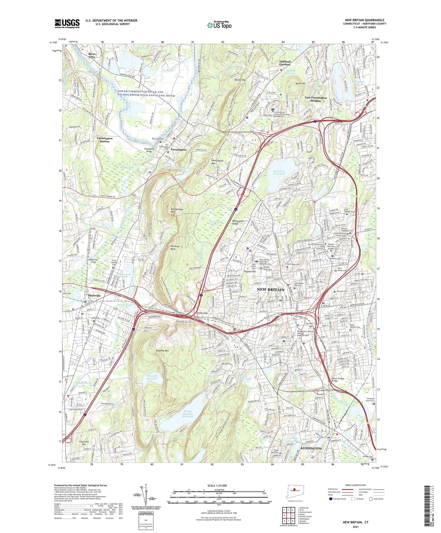
2024 topographic map quadrangle New Britain in the state of Connecticut. Scale: 1:24000. Based on the newly updated USGS 7.5' US Topo map series, this map is in the following counties: Hartford. The map contains contour data, water features, and other items you are used to seeing on USGS maps, but also has updated roads and other features. This is the next generation of topographic maps. Printed on high-quality waterproof paper with UV fade-resistant inks.
Quads adjacent to this one:
West: Bristol
Northwest: Collinsville
North: Avon
Northeast: Hartford North
East: Hartford South
Southeast: Middletown
South: Meriden
Southwest: Southington
This map covers the same area as the classic USGS quad with code o41072f7.
Contains the following named places: Advent Christian Camp, Andrews Cemetery, Arute Athletic Field, Barnesdale Shopping Center, Bass Brook, Batterson Park, Batterson Park Pond, Batterson Park Pond Access Area, Batterson Park Pond Dam, Beech Swamp Bridge, Belcher Brook, Berlin Station, Beth Alom Cemetery, Beth Mishka Cemetery, Blue Hills Cemetery, Bradley Mountain, Bridge Cemetery, Broad Street School, Buena Vista Recreational Complex, Burnt Hill, Burnt Hill Reservoir, Burnt Hill Reservoir Dam, Camp Courant, Camp School, Central Connecticut University, Central Square, Chamberlain Elementary School, Chesley Park, Christian Lane Cemetery, Churchill Hill, City Hall-Monument Historic District, City of New Britain, Columbus Plaza Shopping Center, Cooks Gap, Corbin Heights Housing, Corbin Hospital, Corbins Corner Shopping Center, Corbins Corner Shopping Parkade Shopping Center, Cornerstone Pool, Dead Wood Swamp, DiLoreto Magnet School, Doerrs Pond, Duffy School, E C Goodwin Technical School, Early Learning Center, East Cemetery, East End Park, East Farmington Heights, East Farms Elementary School, Elihu Burnett School, Ervin E Trask School, Fairview Cemetery, Farmington, Farmington Club Polo Grounds, Farmington Country Club, Farmington High School, Farmington Historic District, Farmington Hospital, Farmington Industrial Park, Farmington Mountain, Farmington Reservoir, Farmington Reservoir Dam, Farmington River State Access Area, Farmington Station, Fenn Road Plaza Shopping Center, Frank T Wheeler School, Franklin School, Franklin Square Park, Frederick U Conrad High School, Gaffney Elementary School, Glade Junior High School, Great Brook, Griswold Park, Hale Junior High School, Hamlin Pond, Hamlin Pond Park, Hardware City Shopping Center, Hart Park, Hart Ponds, Hartford Reservoir Number 1, Hatchery Brook, Holmes Elementary School, Holy Cross School, Holy Trinity Cemetery, Hospital for Special Care, Hungerford Park, Hurlbrink Heliport, Hyde Brook, Irving A Robbins Middle School, Irwin Home, Jacobs Corner, Jefferson Elementary School, John Dempsey Hospital, Joseph O Goodwin School, Kensington, Kensington Census Designated Place, Kensington Dam, Kensington School, Kings Plaza Shopping Center, Klingberg Childrens Home, Ledge School, Liberty Mobile Home Park, Lincoln Elementary School, Linden Street Elementary School, Loon Lake, Lower Pond, Mary E Griswold School, Mary Immaculate School, Mason Pond, Miss Porters School, Mooreland Hill Middle School, Mount Pleasant Housing, NBGH Heliport, New Britain, New Brite Plaza Shopping Center, Noah Wallace School, Northend Elementary School, Oakland Gardens, Old Cemetery, Old Farmington Cemetery, Old Saint Mary Roman Catholic Cemetery, Olde Canal Square Plaza Shopping Center, Osgood Heights Park, Osgood Hill, Otis Helistop Division of UTC Heliport, Our Lady of Mercy Parochial School, Paderewski Park, Paderewski Pond, Panther Swamp, Paper Goods Pond, Paper Goods Pond Dam, Patton Brook, Patton Brook Country Club, Pequabuck Bridge, Pequabuck River, Percival Field, Pinnacle Heights Housing, Pinnacle Rock, Plainville, Plainville Heliport, Plainville High School, Plainville Industrial Park, Plainville Junior High School, Plainville Reservoir, Plainville Reservoir Dam, Plainville Stadium, Polish National Catholic Cemetery, Pope Brook, Poplar Swamp Brook, Pulaski High School, Putman School, Quinnipiac Park, Quirk Park, Rattlesnake Mountain, River Glen, Riverside Cemetery, Robertson Field, Rockledge Country Club, Roosevelt Middle School, Russian Orthodox Cemetery, Sacred Heart Cemetery, Sacred Heart School, Saint Francis of Assisi Middle School, Saint Josephs Cemetery, Saint Josephs School, Saint Lucians Childrens Home, Saint Marys Cemetery, Saint Marys Old Cemetery, Saint Marys School, Saint Marys Ukrainian Orthodox Cemetery, Saint Matthews School, Saint Maurice Junior High School, Saint Thomas Aquinas High School, Saint Thomas Cemetery, Scott Swamp Brook, Shade Swamp, Shade Swamp State Wildlife Area, Shultz Pond, Shuttle Meadow Golf Club, Shuttle Meadow Pond, Shuttle Meadow Reservoir, Shuttle Meadow Reservoir Dam, Slade Middle School, Smalley Academy, Smalley Park, Smith School, Smut Island, South Reservoir, South Reservoir Dam, South Reservoir Dike, Southington Shopping Center, Stanley Golf Course, Stanley Park, Stanley Quarter Park, Stanley School, Sunset Rock State Park, Thalberg School, The Epicure Shopping Center, The Exchange Shopping Mall Shopping Center, The Hospital of Central Connecticut New Britain General Campus, Tomasso Nature Park, Town of Farmington, Town of Farmington Open Space, Town of New Britain, Town of Plainville, Treasure Field, Trout Brook Number 1, Trumbull Park, Tunxis Plantation Country Club, University of Connecticut Health Center, Veterans Memorial Stadium, Walnut Hill District Historic District, Walnut Hill Park, Wasel Reservoir Dam, Washington Junior High School, Washington Park, West Ridge Shopping Center, Westfarms Shopping Center, WFCS-FM (New Britain), Whiting Industrial Park, Willow Brook Park, WNEZ-AM (New Britain), Wolcott Park, Wood Pond, Woodridge Lake, Woodridge Lake Dam, WPOP-AM (Hartford), WRCH-FM (New Britain), WTIC-TV (Hartford), WVIT-TV (New Britain), ZIP Codes: 06032, 06051, 06052, 06053, 06062