
MyTopo
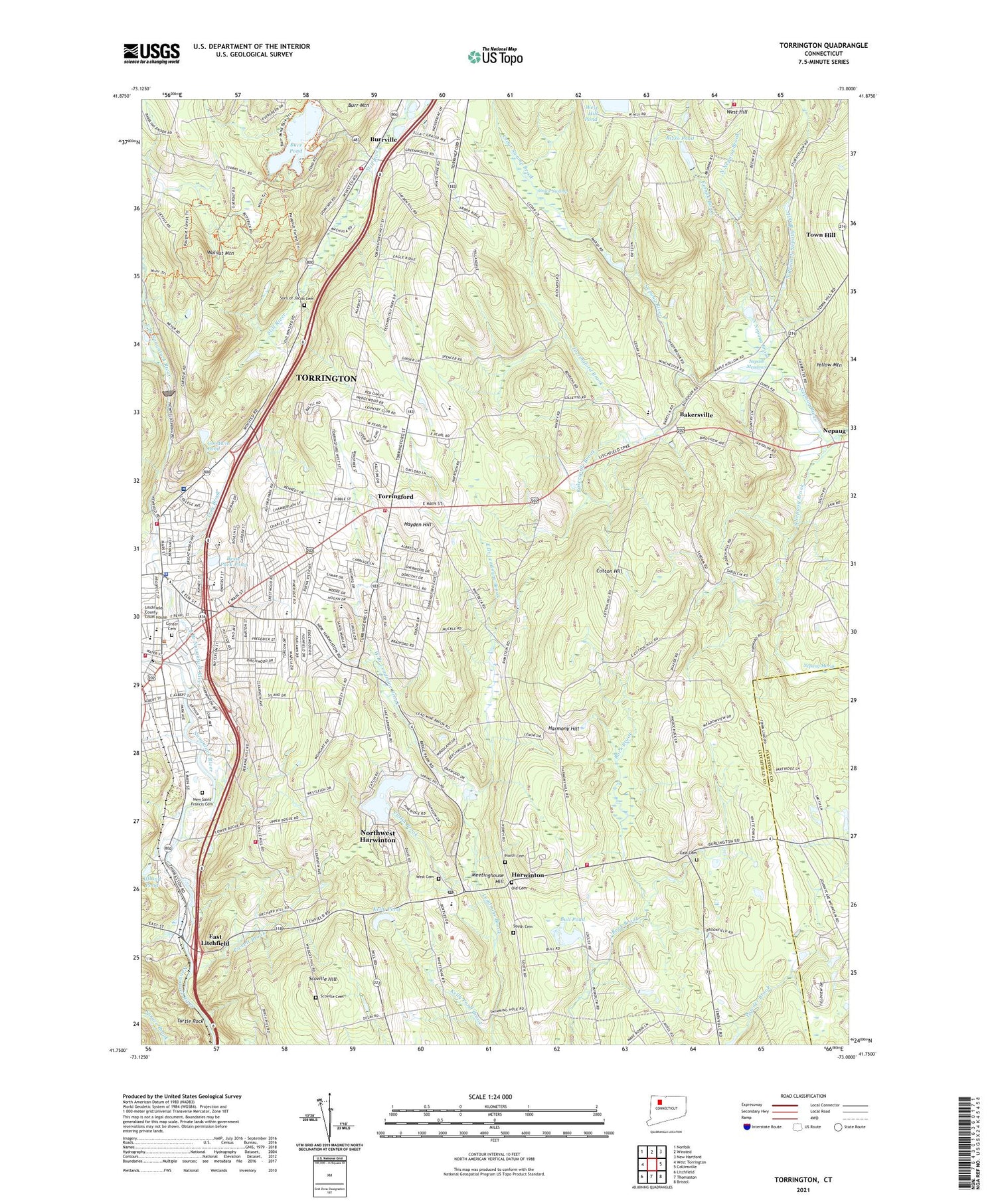
Torrington Connecticut US Topo Map
Couldn't load pickup availability
2024 topographic map quadrangle Torrington in the state of Connecticut. Scale: 1:24000. Based on the newly updated USGS 7.5' US Topo map series, this map is in the following counties: Litchfield, Hartford. The map contains contour data, water features, and other items you are used to seeing on USGS maps, but also has updated roads and other features. This is the next generation of topographic maps. Printed on high-quality waterproof paper with UV fade-resistant inks.
Quads adjacent to this one:
West: West Torrington
Northwest: Norfolk
North: Winsted
Northeast: New Hartford
East: Collinsville
Southeast: Bristol
South: Thomaston
Southwest: Litchfield
This map covers the same area as the classic USGS quad with code o41073g1.
Contains the following named places: Alvord Park, Ann Antolini School, Bakersville, Bakersville Brook, Bakerville Consolidated School, Bakerville Library, Bakerville Methodist Church, Besse Park Pond, Birge Park Shopping Center, Boy Scout Service Center, Bull Pond, Bull Pond Dam, Burr Pond, Burr Pond Dam, Burr Pond State Park, Burrville, Burrville Regional Fire School, Burrville Volunteer Fire Department, Calvary Baptist Church, Camp Berkshire, Camp Trinita, Catlin Brook, Cedar Swamp, Cedar Swamp Brook, Center Cemetery, Center Congregational Church, Church of Christ, City of Torrington Street Division Garage, Coe Memorial Park, Cotton Hill, Downtown Torrington Historic District, East Branch Dam, East Branch Leadmine Brook, East Branch Naugatuck River, East Branch Naugatuck River Reservoir, East Cemetery, East Elementary School, East Litchfield, East School, Elise Besse Park, Faith Tabernacle Apostolic Church, Finnak Brook, First Assembly of God Church, Founders Congregational Church, Four Corners, Fuessenich Park, Full Gospel Lighthouse Church, Goodwin Pond, Gulf Stream, Harmony Hill, Harvest Baptist Church, Harwinton, Harwinton Ambulance Association, Harwinton Community Hall, Harwinton Congregational Church, Harwinton Conservation and Recreation Area, Harwinton Consolidated School, Harwinton Fair Grounds, Harwinton Post Office, Harwinton Public Library, Harwinton Shopping Center, Harwinton Town Garage, Harwinton Town Hall, Harwinton Volunteer Fire Department, Harwinton Westside Volunteer Fire Department, Hayden Hill, Hotchkiss-Fyler House, Hungerford Memorial Library, Iffland Pond, Immaculate Heart of Mary Church, Joe Ruwet Playground, John Thompson Memorial Library, John Toro Sports Complex, Kasznay Shopping Center, Kelly Pond, Kelly Pond Brook, Lake Harwinton, Lake Harwinton Dam, Living Faith Christian Center, Maple Hollow, Meetinghouse Hill, Mountain Meadow Airstrip, Nepash Meadows, Nepaug Marsh, New Hartford Fire Department Station 2, New Saint Francis Cemetery, North Brook North Nepaug Brook, North Cemetery, North Nepaug Brook, Northwest Harwinton Census Designated Place, O and G Heliport, Old Post Office Square Shopping Center, Oxbow Park, Patterson Park, Paugnut State Forest, Pickett Brook, Pleasant View Park, Powder Brook, Rizzo Pond, Rizzo Pond Dam, Scoville Cemetery, Scoville Hill, Sons of Jacob Cemetery, South Cemetery, South Nepaug Brook, South School, Torringford, Torringford Brook, Torringford Church, Torringford Elementary School, Torringford Volunteer Fire Department, Torrington, Torrington Fire Department Headquarters, Torrington Fire Department North End Station, Torrington Library, Torrington Police Department, Town of Harwinton, Town of New Hartford, Travis Pond, Troy Brook, Turtle Rock, United Church of Christ, Vogel-Wetmore School, Walnut Mountain, West Branch Leadmine Brook, West Branch Naugatuck River, West Cemetery, West Hill, Western Connecticut Mental Health Care System, Wolcott School, WSNG-AM (Torrington), Yellow Mountain, ZIP Code: 06791


