MyTopo
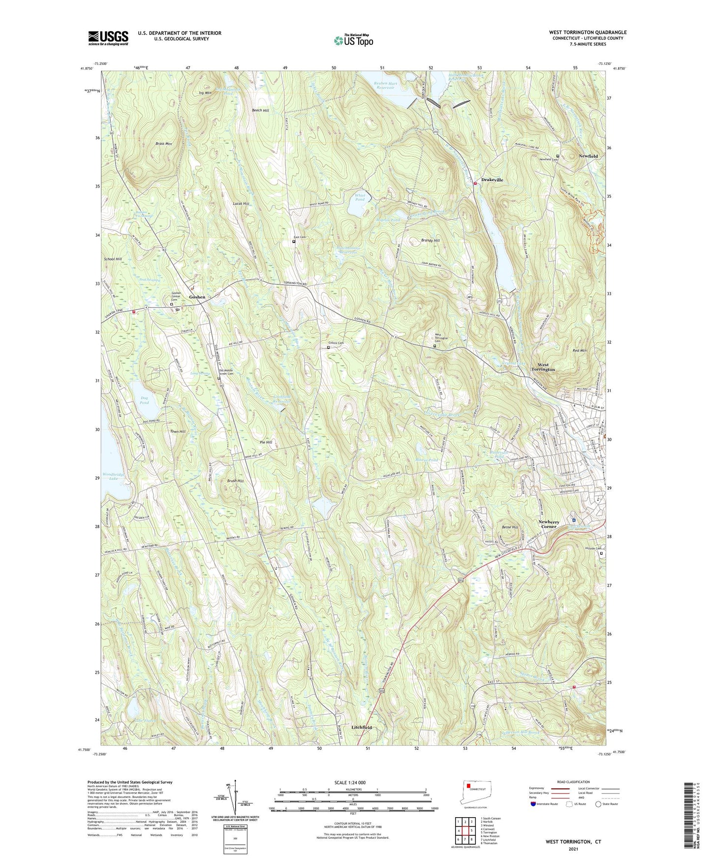
West Torrington Connecticut US Topo Map
Couldn't load pickup availability
2024 topographic map quadrangle West Torrington in the state of Connecticut. Scale: 1:24000. Based on the newly updated USGS 7.5' US Topo map series, this map is in the following counties: Litchfield. The map contains contour data, water features, and other items you are used to seeing on USGS maps, but also has updated roads and other features. This is the next generation of topographic maps. Printed on high-quality waterproof paper with UV fade-resistant inks.
Quads adjacent to this one:
West: Cornwall
Northwest: South Canaan
North: Norfolk
Northeast: Winsted
East: Torrington
Southeast: Thomaston
South: Litchfield
Southwest: New Preston
This map covers the same area as the classic USGS quad with code o41073g2.
Contains the following named places: Allen Dam, Balsam Fir Swamp, Beech Hill, Besse Hill, Borzani Park, Brandy Hill, Brass Mountain, Brush Hill, Camp Birchwood, Camp Cochipianee, Camp Toguam, Charlotte Hungerford Hospital, Christian Apostolic Church, Church Street Reservoir, City of Torrington, Collins Cemetery, Crystal Lake, Crystal Lake Dam, Dog Pond, Drake Pond Brook, Drakeville, Drakeville Volunteer Fire Department, East Cemetery, East Litchfield Volunteer Fire Company, First Pentecostal Church, Fox Brook, Friendship Baptist Church, Goshen, Goshen Academy, Goshen Center Cemetery, Goshen Center School, Goshen Fire Marshal's Office, Goshen Historic District, Goshen Historical Society Building, Goshen Historical Society Library, Goshen Library, Goshen Post Office, Goshen Town Offices, Goshen Volunteer Fire Company, Hall Meadow Brook, Hall Meadow Brook Dam, Hall Meadow Brook Dike, Hall Meadow Brook Reservoir, Harry S Fisher Middle School, Hart Brook, Hatchaloosie Reservoir, Hemlock Hill Campground, Hillside Cemetery, Ivy Mountain, Ivy Mountain Brook, Ivy Mountain Pond, Ivy Mountain Pond Dam, Ivy Mountain State Park, Jakes Brook, John Browns Birthplace, Junior Republic of Connecticut, Lake Floren, Lake Floren Dam, Litchfield County, Litchfield County Center for Higher Education, Litchfield County Christian Church, Litchfield Reservoir, Litchfield School for Boys, Long Swamp, Lovers Lane Brook, Lucas Hill, Major Besse Park, Maria Pratt Girl Scout Camp, Marshall Lake Brook, Memorial Hospital, Migeon Pond, Miscus Pond, Newberry Corner, Newfield, Newfield Cemetery, Nickel Mine Brook, Old Goshen Town Hall, Old Middle Street Cemetery, Patterson Pond, Peat Swamp, Pie Hill, Pierce Academy, Red Mountain, Reuben Hart Reservoir, Reuben Hart Reservoir Dam, Riverside School, Saint Louis De Montfort Seminary, Southwest School, Stillwater Pond, Stillwater Pond Dam, The Forbes School, The Forman School, Torrington Country Club, Torrington Library University of Connecticut, Town Hill, Town of Goshen, Town of Torrington, West Branch Bantam River, West Branch Dam, West Torrington, West Torrington Cemetery, Whist Pond, Whist Pond Dam, Wrightville, ZIP Codes: 06756, 06759, 06790