MyTopo
Woodbury Connecticut US Topo Map
Couldn't load pickup availability
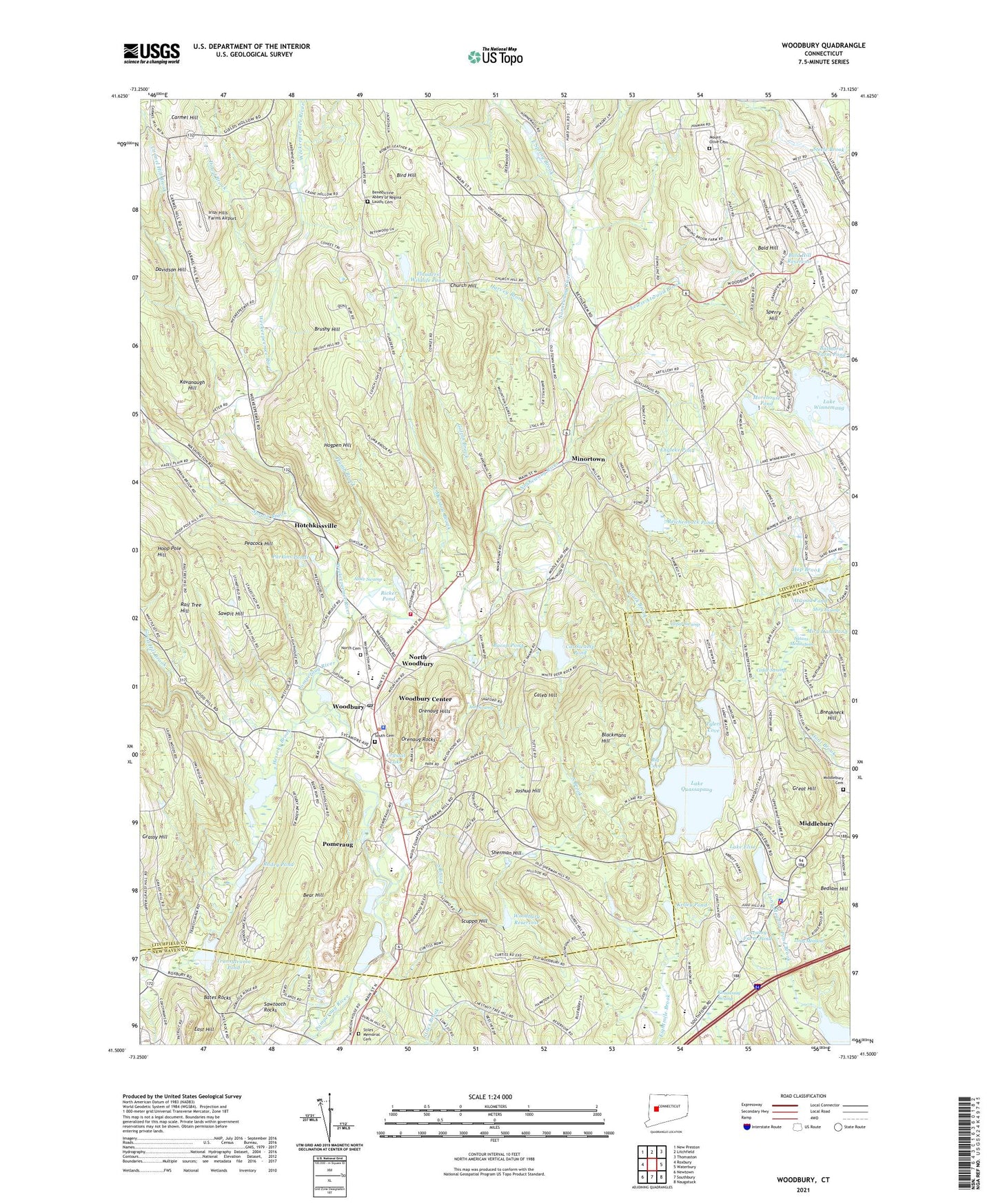
2024 topographic map quadrangle Woodbury in the state of Connecticut. Scale: 1:24000. Based on the newly updated USGS 7.5' US Topo map series, this map is in the following counties: Litchfield, New Haven. The map contains contour data, water features, and other items you are used to seeing on USGS maps, but also has updated roads and other features. This is the next generation of topographic maps. Printed on high-quality waterproof paper with UV fade-resistant inks.
Quads adjacent to this one:
West: Roxbury
Northwest: New Preston
North: Litchfield
Northeast: Thomaston
East: Waterbury
Southeast: Naugatuck
South: Southbury
Southwest: Newtown
This map covers the same area as the classic USGS quad with code o41073e2.
Contains the following named places: Abbey of Regina Laudis Library, Acropolis, Alder Swamp, Ash Swamp, Atwood Pond, Avalon Farm Pond, Bacon Pond, Bald Hill, Bald Hill Reservoir, Barclay Square Shopping Center, Bates Rocks, Bear Hill, Big Cove, Bird Hill, Blackmans Hill, B'Nai Israel, Breakneck Hill, Brushy Hill, Caleb Hill, Carmel Hill Brook, Cat Swamp Pond, Cat Swamp Pond Dam, Cedar Swamp, Church Hill, Clark Brook, Crystal Lake, Davidson Hill, Dowd Brook, East Hill, East Meadow Brook, East Spring Brook, Engleke Pond, Flanders Elementary School, Flanders Nature Center, Flanders Wildlife Pond, Flanders Wildlife Pond Dam, Fletcher W Judson School, Galpin Brook, Glebe House, Good Hill Brook, Great Hill, Great Hill Lookout Tower, Harvey Brook, Hesseky Brook, Hesseky Meadow Pond, Hogpen Hill, Hollow Park, Hoop Pole Hill, Hotchkissville, Hotchkissville Fire Department, Irish Hills Farms Airport, Joshua Hill, Kavanaugh Hill, Kelley Pond, Kissawaug Swamp, Lake Elise, Lake Elise Dam, Lake Quassapaug, Lake Quassapaug Dam, Lake Winnemaug, Lake Winnemaug Dam, Lewis Atwood Brook, Long Meadow, Middle Quarter Mall Shopping Center, Middlebury, Middlebury Cemetery, Middlebury Police Department, Middlebury Volunteer Fire Department Station 2, Minortown, Miry Swamp, Mitchell Elementary School, Morehouse Pond, Mount Olive Cemetery, Nonnewaug River, North Cemetery, North Woodbury, Orenaug Hills, Orenaug Rocks, Paradise Valley Farm, Parkins Ponds, Peacock Hill, Pilgrim Mall Shopping Center, Pine Corners, Plumb Brook, Pomeraug, Quassy Amusement Park, Radey Pond, Rag Land, Rail Tree Hill, Regina Laudis Priory, Reichenback Pond, Ricker Pond, Satans Meditation, Sawpit Hill, Sawtooth Rocks, Scuppo Hill, Sherman Hill, South Brook, South Cemetery, Sperry Hill, Sprain Brook, Stiles Brook, Stiles Memorial Cemetery, Town of Woodbury, Transylvania Pond, Transylvania Pond Dam, Tylers Cove, Watertown Pumping Station, Weekeepeemee River, White Oaks, Woodbury, Woodbury Ambulance Association, Woodbury Center Census Designated Place, Woodbury Police Department, Woodbury Post Office, Woodbury Reservoir, Woodbury Volunteer Fire Department / Orenaug Fire Company, ZIP Codes: 06795, 06798