MyTopo
Newtown Connecticut US Topo Map
Couldn't load pickup availability
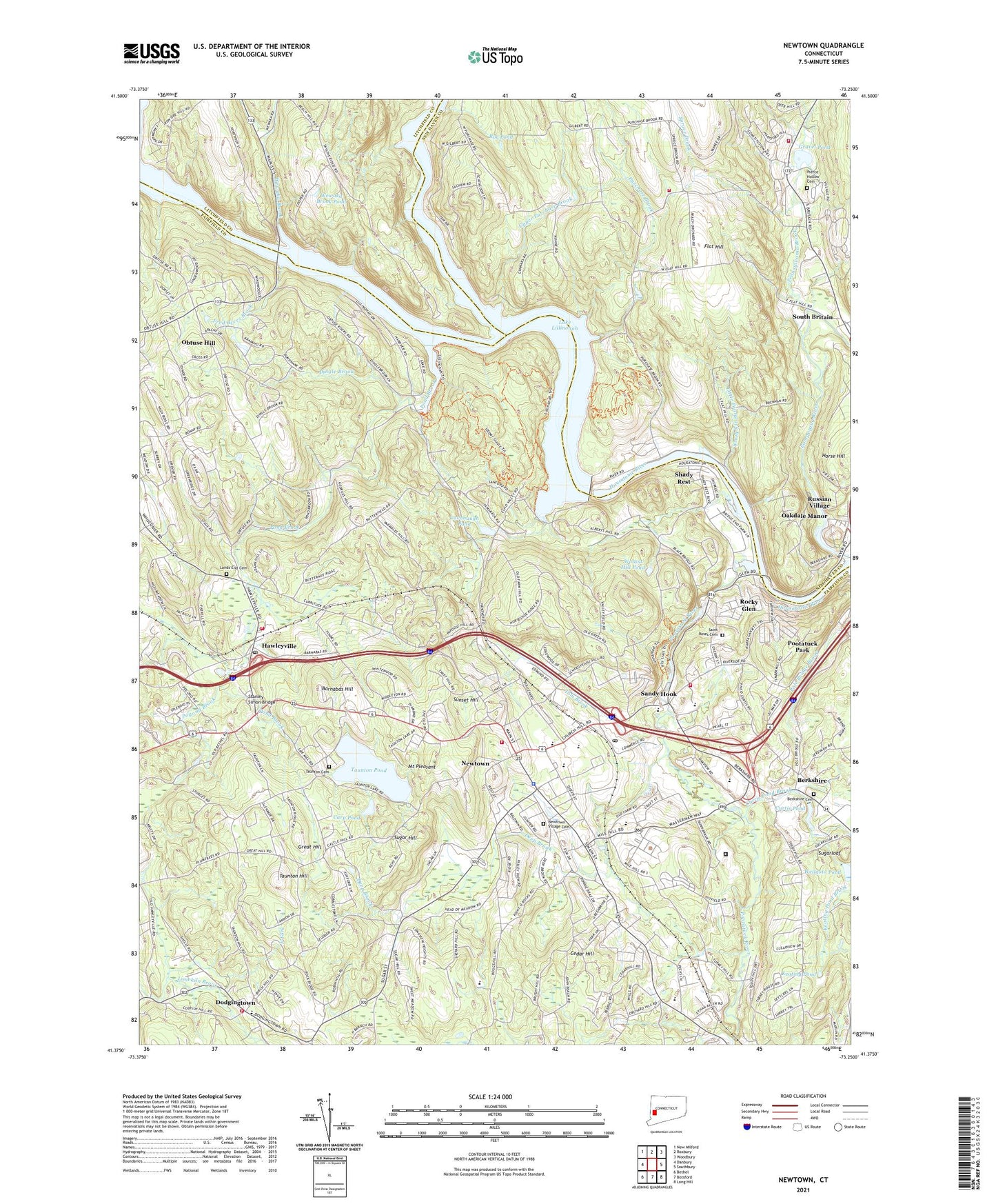
2024 topographic map quadrangle Newtown in the state of Connecticut. Scale: 1:24000. Based on the newly updated USGS 7.5' US Topo map series, this map is in the following counties: Fairfield, New Haven, Litchfield. The map contains contour data, water features, and other items you are used to seeing on USGS maps, but also has updated roads and other features. This is the next generation of topographic maps. Printed on high-quality waterproof paper with UV fade-resistant inks.
Quads adjacent to this one:
West: Danbury
Northwest: New Milford
North: Roxbury
Northeast: Woodbury
East: Southbury
Southeast: Long Hill
South: Botsford
Southwest: Bethel
This map covers the same area as the classic USGS quad with code o41073d3.
Contains the following named places: Barnabas Hill, Bend of the River Sanctuary, Berkshire, Berkshire Cemetery, Berkshire Estates, Bible Baptist Church, Borough of Newtown, Carp Pond, Cavanaugh Brook, Cavanaugh Pond, Cedar Hill, Christ the King Lutheran Church, Cold Spring Brook, Curtis Pond, Curtis Pond Brook, Curtis Pond Dam, Cyrenius H Booth Library, Deep Brook, Dickinson Memorial Park, Dingle Brook, Dodgingtown, Dodgingtown Census Designated Place, Dodgingtown Volunteer Fire Company, East Fork, Fairfield State Hospital, Flat Hill, Fred Beers Brook, Garner Correctional Institution, George C Waldo State Park, Grace Fellowship Church, Gravel Pond, Gravel Pond Dam, Great Hill, Hawley Elementary School, Hawleyville, Hawleyville Census Designated Place, Hawleyville Post Office, Hawleyville Volunteer Fire Company 1, Hed O'Meadow Elementary School, Horse Hill, Keating Pond, Keating Pond Brook, Lake Lillinonah, Lands End Cemetery, Lands End School, Little Pootatuck Brook, Morgan Fair Corners, Mount Pleasant, Newbury Congregational Church, Newtown, Newtown Congregational CHurch, Newtown Country Club, Newtown Fire Department Hook and Ladder, Newtown Fire Marshal's Office, Newtown High School, Newtown Middle School, Newtown Police Department, Newtown Post Office, Newtown Shopping Center, Newtown United Methodist Church, Newtown Village Cemetery, Newtown Volunteer Ambulance Corps, North Branch Pootatuck River, Oakdale Manor, Obtuse Hill, Old Town Museum, Pierce Hollow Cemetery, Pleasant Valley Picnic Area, Pogond Brook, Pomperaug River, Pond Brook, Pootatuck Park, Pootatuck River, Pootatuck River Reservoir, Purchase Brook, Rickys Shopping Center, Rock Ridge Country Club, Rocky Glen, Rocky Glen Dam, Rocky Glen State Park, Roe Pond, Russian Village, Russian Village Historic District, Saint Johns Episcopal Church, Saint Roses Cemetery, Sandy Hook, Sandy Hook Dam, Sandy Hook Elmentary School, Sandy Hook Fire Rescue Company Station 1 Headquarters, Sandy Hook Plaza Shopping Center, Sandy Hook Post Office, Shady Rest, Shedpaug Dam, Shepaug River, Sheraug Dam, South Britain, South Britain Congregational Church, South Britain Historic District, Southbury Training School, Southbury Training School Fire Department, Southbury Volunteer Fire Department Purchase Fire House, Spruce Brook, Stanley Simon Bridge, Sugar Hill, Sugarloaf, Sunset Hill, Taunton Cemetery, Taunton Hill, Taunton Pond, Taunton Pond Dam, The Bent, The Village Square Shopping Center, Tom Brook, Town of Newtown, Town Park, Transylvania Brook, Treadwell Memorial Park, Trinity Episcopal Church, Trinity Episcopal Church Library, Twin Bridges Picnic Area, Upper Purchase Brook, Walnut Hill Pond, Walnut Hill Pond Dam, Wellgoto Pond, Wellgoto Pond Dam, Wewaka Brook, Wewaka Brook Pond, Wewaka Brook Pond Dam, Wheeler Shopping Center, ZIP Code: 06470