MyTopo
Wyoming Delaware US Topo Map
Couldn't load pickup availability
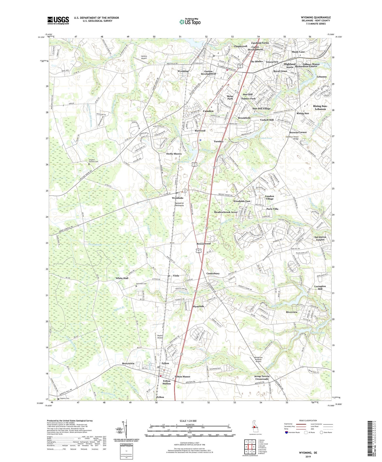
2023 topographic map quadrangle Wyoming in the state of Delaware. Scale: 1:24000. Based on the newly updated USGS 7.5' US Topo map series, this map is in the following counties: Kent. The map contains contour data, water features, and other items you are used to seeing on USGS maps, but also has updated roads and other features. This is the next generation of topographic maps. Printed on high-quality waterproof paper with UV fade-resistant inks.
Quads adjacent to this one:
West: Marydel
Northwest: Kenton
North: Dover
Northeast: Little Creek
East: Frederica
Southeast: Milford
South: Harrington
Southwest: Burrsville
This map covers the same area as the classic USGS quad with code o39075a5.
Contains the following named places: Alexanders Village, Allabands Mill Stream, Allee, Alms House, Almshouse Branch, Andrews Lake, Andrews Lake Estates, Barclay Farms, Beades Estate, Berrytown, Bible Fellowship Church, Big Union Circuit, Bonwell House, Bork Acres, Breck Nock Park, Breezewood, Briar Park, Brookfield, Browns Corner, Burwood, Burwood Farms, Caesar Rodney High School, Caesar Rodney Junior High School, Caesar Rodney School District, Calvary Assembly of God Church, Camden, Camden - Wyoming Volunteer Fire Company, Camden Police Department, Camden Town Center Shopping Center, Camden Town Hall, Camden Wyoming Post Office, Candlewicke, Canterbury, Canterbury Trails, Canterville, Capitol City Church of Christ, Carriage Lane, Carter Development, Central Kent Division, Chaplecroft, Chimney Hill, Christ Memorial Baptist Church, Clarence Vinson Bridge, Cow Marsh Ditch, Del Haven Estates, Derby Pond, Derby Pond Dam, Derby Shores, Derbywood, Downham Cemetery, Doyle's Airport, Eagles Nest, East Dover Hundred, Emmanuel Pentecostal Church of God, Fairfield Farms, Faith Community Church, Felton, Felton Community Fire Company, Felton Heights, Felton Manor, Felton Police Department, Felton Post Office, Felton Station, Felton Town Hall, Felton United Methodist Church, First Pilgrim Baptist Church, Forest Landing, Garton Development, Golden Thicket, Granada Mobile Home Park, Great Geneva, Greater Life Christian Church, Green Acres Mobile Home Park, Greenview, Harrison Knoll, Harvest Years Senior Center, Henderson Aviation Airport, Heron Drain, Hidden Pond, Highland Acres, Highland Acres Census Designated Place, Hillside Acres, Hopkins Cemetery, Howell Pond, Hudson Trails, Jackson Farms, Jenkins Airport, Johnson Square Park, Kent Center Vocational Technical High School, Kent County, Kent County Public Library, Kingdom Holiness Cemetery, Kingdom Worship Center, Lake Forest High School, Lake Forest North Elementary School, Lakewind, Lakewind III, Lebanon, Lebanon Wesleyan Church, Lexington Mill, London Village, Lone Star Mobile Home Park, Maranatha Baptist Church, Markeys Mobile Home Park, McGinnis Pond, McGinnis Pond Dam, Meadow Glen, Meadowbrook Acres, Melbourne Manor, Mifflin Meadows, Mount Plymouth Church, Nellie Hughes Stokes Elementary School, Newell Branch, Newell Creek, Normansmeade, North Murderkill Hundred, Oaknoll, Orchard Acres, Oxyoke Mobile Home Park, Palmer Park, Paris Villa, Pennwood, Pharsalia, Pickwick Acres, Pleasant Hill, Plymouth, Red House Branch, Richardson Estates, Rising Sun, Rising Sun Mobile Home Park, Rising Sun-Lebanon Census Designated Place, Riverdale Estates Mobile Home Park, Riverview, Riverview Census Designated Place, Rockland Hills, Royal Grant, Saint James Church, Saint Johns Church, Saint Pauls Church, Scrap Tavern Crossroads, Shady Lane, South Murderkill Hundred, Southside Baptist Church, Southwood Acres Mobile Home Park, Star Hill, Star Hill African Methodist Episcopal Church, Star Hill Church, Star Hill Elementary School, Star Hill Village, Summerfield Village, The Blades, The Church of Jesus Christ of Latter Day Saints, The Flying Dutchman Mobile Home Park, The Orchard, The Village at Wild Quail, Tidbury Creek Park Mobile Home Park, Tidbury Manor, Tidbury Park, Town of Camden, Town of Felton, Town of Viola, Town of Woodside, Town of Wyoming, Townsend Fields, Turnkey, Union Church, Union School, Village at Chestnut Ridge, Viola, Viola Post Office, Viola School, Viola Woods, Voshell Mill, Voshell Mill Pond Dam, Voshell Pond, Whatcoat United Methodist Church, Whispering Pines Mobile Home Park, White Hall, Wild Quail Golf and Country Club, Willow Grove Church of God, Winmill, Woodbury, Wooden Bridge, Woodfield, Woodside, Woodside Center Shopping Center, Woodside East Census Designated Place, Woodside Post Office, Woodside Town Hall, Woodside United Methodist Church, Wynn Wood, Wyoming, Wyoming Lake, Wyoming Lake Dam, Wyoming Mills, Wyoming Police Department, Wyoming Town Hall, Wyoming United Methodist Church, ZIP Codes: 19943, 19979