MyTopo
Eastport Florida US Topo Map
Couldn't load pickup availability
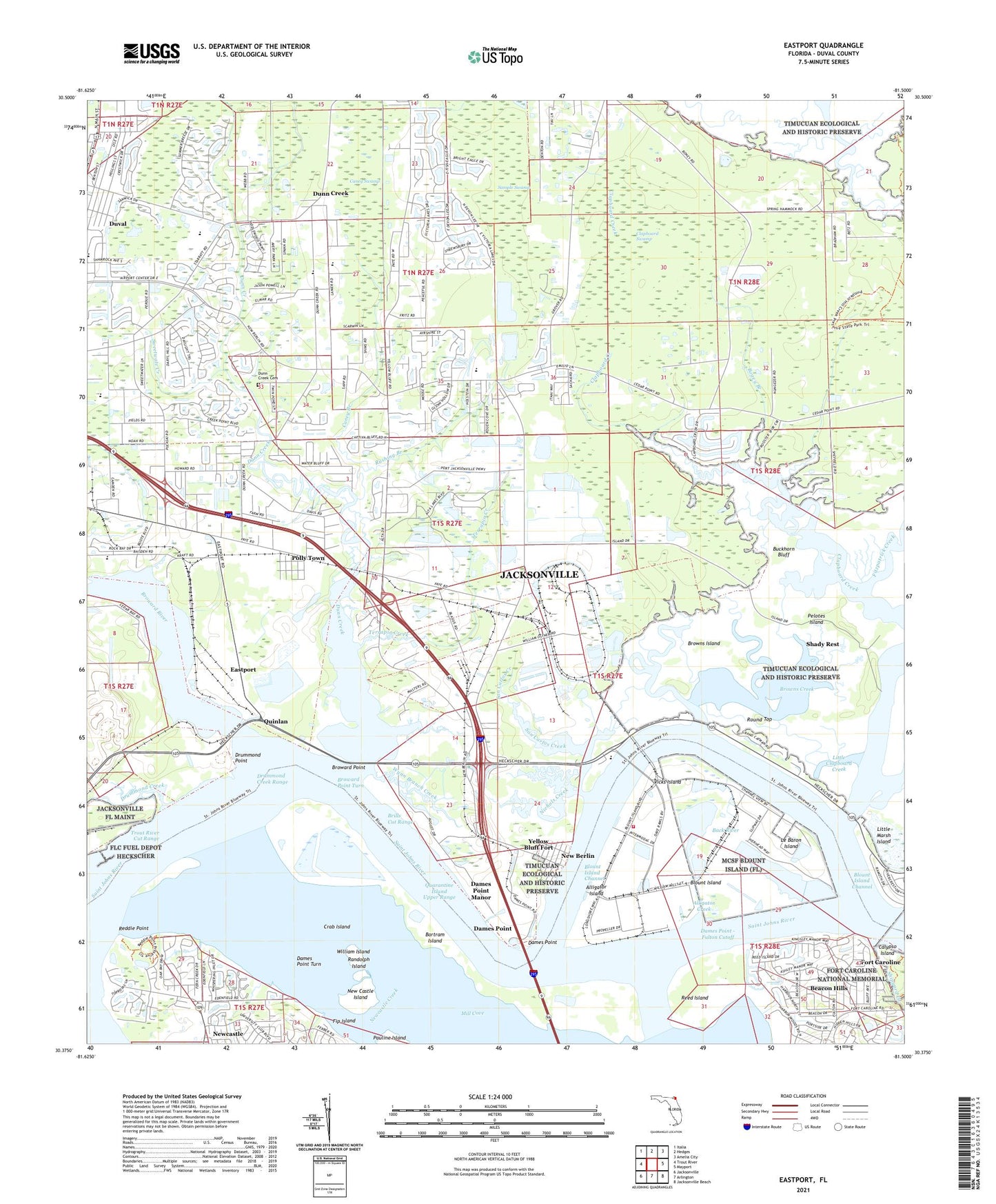
2024 topographic map quadrangle Eastport in the state of Florida. Scale: 1:24000. Based on the newly updated USGS 7.5' US Topo map series, this map is in the following counties: Duval. The map contains contour data, water features, and other items you are used to seeing on USGS maps, but also has updated roads and other features. This is the next generation of topographic maps. Printed on high-quality waterproof paper with UV fade-resistant inks.
Quads adjacent to this one:
West: Trout River
Northwest: Italia
North: Hedges
Northeast: Amelia City
East: Mayport
Southeast: Jacksonville Beach
South: Arlington
Southwest: Jacksonville
This map covers the same area as the classic USGS quad with code o30081d5.
Contains the following named places: A Atkinson or F P Sanchez Grant, Alligator Creek, Alligator Island, Andrew Atkinson Grant, Back River, Bartram Island, Beacon Hills, Berlin Heliport, Bethel Church, Blount Island, Blount Island Channel, Blount Island Command, Bogey Branch, Brills Cut Range, Broward Point, Broward Point Turn, Broward River, Browns Creek, Browns Creek Fish Camp Marina, Browns Island, Buckhorn Bluff, Calvary Temple Church of God, Calypso Island, Caney Branch, Caney Swamp, Charles Seton Grant, Chaseville, Clapboard Creek, Clapboard Creek Marina, Clapboard Lookout Tower, Clapboard Swamp, Crab Island, Dames Point, Dames Point - Fulton Cutoff, Dames Point Manor, Dames Point Turn, Domingo Fernandez Grant, Drummond Creek, Drummond Creek Range, Drummond Point, Dunn Creek, Dunn Creek Cemetery, Dunn Creek Park, Dunns Creek Baptist Church Day Care Center, Dunns Creek Church, Duval, Duval Station Baptist Church, Eastport, Eastport Church, F M Arredondo Grant, Faith Academy, Fip Island, First Coast Christian Center, First Coast High School, Fitzpatrick Creek, Fort Caroline, Francis Richard Grant, Gate Maritime Properties Berth 1, Gate Maritime Properties Berth 2, Gate Maritime Properties Berth 3, Gate Maritime Properties Berth 4, Gate Maritime Properties Berth 5, Grover Road Baptist Church, Heckscher Drive Church, Hutto Chapel, Jacksonville Fire and Rescue Department Station 48, Jacksonville North Division, Jacksonville Port Authority Ed Austin Marine Terminal Wharf, John Broward Grant, John Christopher Grant, John F Brown Grant, John G Rushing Grant, Kingdom Hall of Jehovahs Witnesses, Le Baron Island, Little Clapboard Creek, Louis S Sheffield Elementary School, Mill Cove, Nassau River-St Johns River Marshes State Aquatic Preserve, New Berlin, New Berlin Road Baptist Church, New Castle Island, Nichols Creek, Northside Generating Power Plant, Oak Grove Church, Oceanway Elementary School, Oceanway Village Mobile Home Park, Pauline Island, Pelotes Island, Polly Town, Quarantine Island Upper Range, Quinlan, R Sanchez Grant, Randolph Island, Reddie Point, Reddie Point Post Light, Reed Island, Resurrection Episcopal Church, Round Top, Rushing Branch, Saint Johns River Power Plant, Saint Marks Church, Sample Swamp, San Carlos Creek, Shipyard Creek, Sweetwate Creek, Terrapin Creek, Tom Marshall Park, Trout River Cut Range, Vicks Island, William Drummond Grant, William Island, Wynn Branch Creek, Yellow Bluff Fort, Yellow Bluff Fort Historic State Park, ZIP Codes: 32226, 32277