MyTopo
Hedges Florida US Topo Map
Couldn't load pickup availability
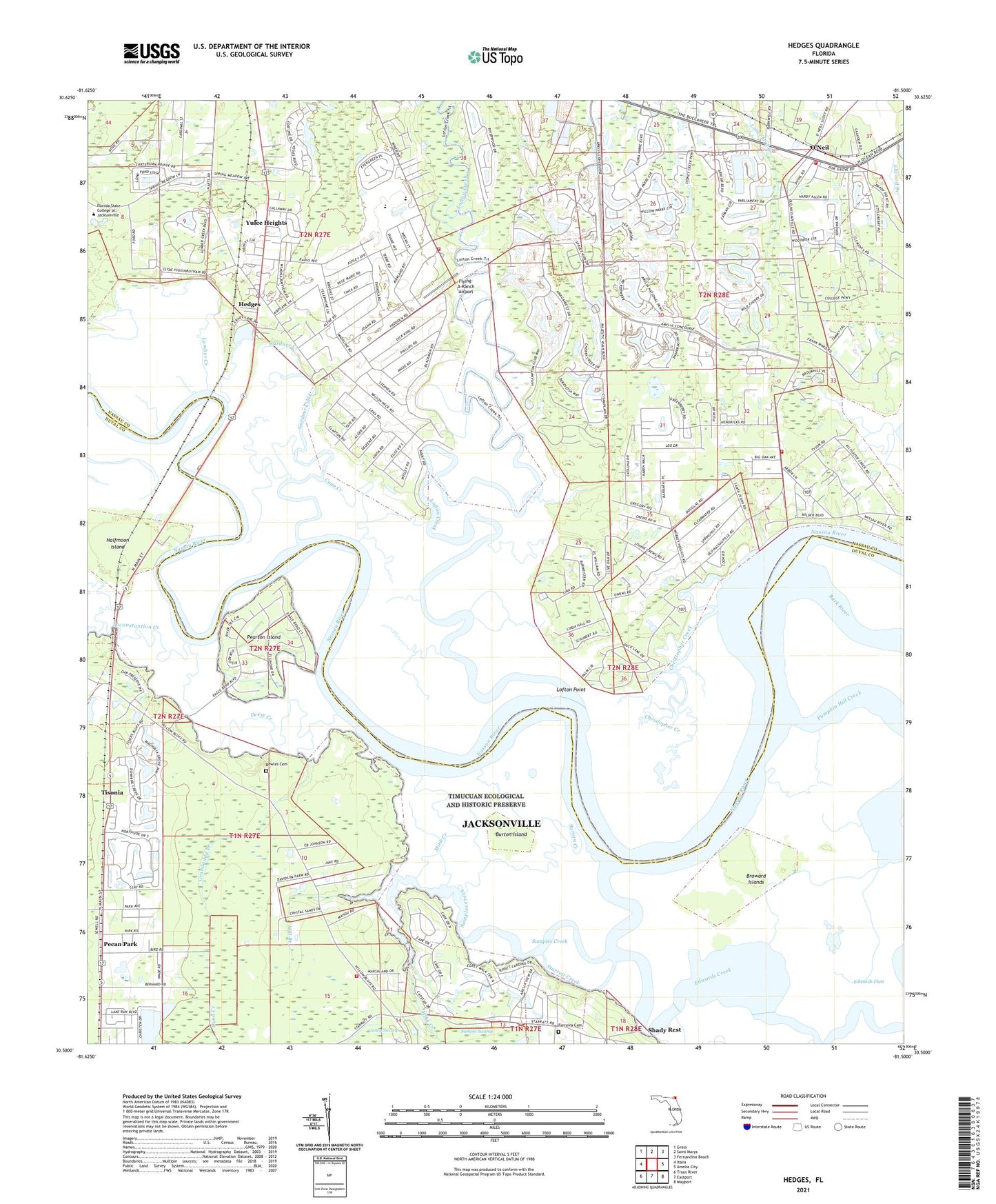
2024 topographic map quadrangle Hedges in the state of Florida. Scale: 1:24000. Based on the newly updated USGS 7.5' US Topo map series, this map is in the following counties: Nassau, Duval. The map contains contour data, water features, and other items you are used to seeing on USGS maps, but also has updated roads and other features. This is the next generation of topographic maps. Printed on high-quality waterproof paper with UV fade-resistant inks.
Quads adjacent to this one:
West: Italia
Northwest: Gross
North: Saint Marys
Northeast: Fernandina Beach
East: Amelia City
Southeast: Mayport
South: Eastport
Southwest: Trout River
This map covers the same area as the classic USGS quad with code o30081e5.
Contains the following named places: Bowles Cemetery, Broward Islands, Burton Creek, Burton Island, Christopher Creek, Cuno Creek, Cyrus Briggs Grant, Deese Creek, Edwards Creek, Edwards Flats, Ferreira Cemetery, Flying-A-Ranch Airport, Gardner Creek, Grandaddy Branch, Halfmoon Island, Halfmoon Park, Hawks Nest Golf Club, Hedges, Henderson Landing, Homer Landing, Inconstantion Creek, J Bachlott Grant, Jacksonville Fire and Rescue Department Station 49, Jerry Landing, John Houston Grant, Lofton Creek, Lofton Point, Lumber Creek, Memorial Church, Mill Branch, Mink Creek, Moses Harrold Grant, Mount Zion Church, Nassau County Fire and Rescue Station 3A, Nassau County Fire and Rescue Station 7, Nassau County Fire and Rescue Station 70, Nassauville, O'Neil, Pearson Island, Pecan Park, Pine Grove Church, Pleasant Park Church, Prince Chapel, Pumpkin Hill Creek, Samples Creek, Sarah Broward Grant, Shady Rest, Spring Hill Church, Starrett Creek, Stephen Eubanks Grant, Timucuan Ecological and Historic Preserve, Tisonia, Tisonia Lookout Tower, William Eubanks Grant, William Hendricks Grant, WNLE-FM (Fernandina Beach), Wrights Landing, Yulee Heights, Yulee Middle School