MyTopo
Fairburn Georgia US Topo Map
Couldn't load pickup availability
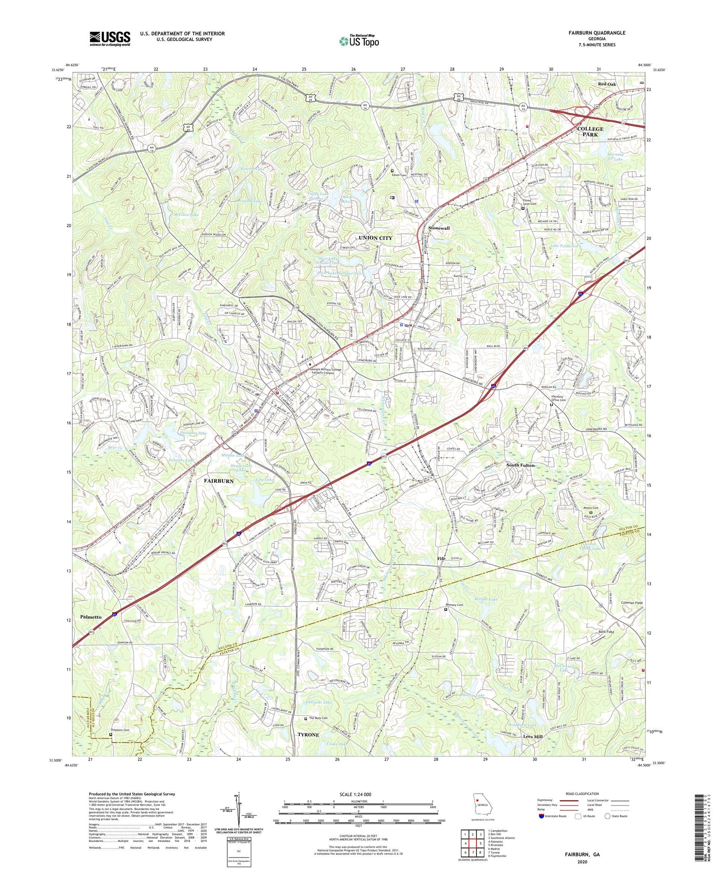
2024 topographic map quadrangle Fairburn in the state of Georgia. Scale: 1:24000. Based on the newly updated USGS 7.5' US Topo map series, this map is in the following counties: Fulton, Fayette, Coweta. The map contains contour data, water features, and other items you are used to seeing on USGS maps, but also has updated roads and other features. This is the next generation of topographic maps. Printed on high-quality waterproof paper with UV fade-resistant inks.
Quads adjacent to this one:
West: Palmetto
Northwest: Campbellton
North: Ben Hill
Northeast: Southwest Atlanta
East: Riverdale
Southeast: Fayetteville
South: Tyrone
Southwest: Madras
This map covers the same area as the classic USGS quad with code o33084e5.
Contains the following named places: Arnolds Lake, Arnolds Lake Dam, Beck Field, Bench Mark, Benjamin Banneker High School, Bethany, Bethany Cemetery, Bethany Church, Bethel Church, Bradbury Lake, Bradbury Lake Dam, Brandon Hill, Brogdon, Buffington Road Church, C H Gullatt Elementary School, Calvary Church, Campbell County Courthouse, Campbell Elementary School, Christian City Childrens Home, Christian Corners, City Lake, City Lake Dam, City of Fairburn, City of Union City, Coleman Field, Cooks Lake, Cooks Lake Dam, Cornerstone Church, Crossroads Second Chance School South, Dixie Lake Dam Number One, Dixie Lake Number One, Dixie Lake Number Two, Dixie Lake Number Two Dam, Dixie Lakes, Dixie Lakes Park, Duncan Memorial Park, Durhams Dam, Durhams Lake, Eason Cemetery, Edwards Lake, Eubanks Lake, Evoline C West Elementary School, Fairburn, Fairburn City Hall, Fairburn Commercial Historic District, Fairburn Elementary School, Fairburn Fire Department, Fairburn Industrial Park, Fairburn Police Department, Fairburn Post Office, Fairburn-Union City Division, Fayette County Fire and Emergency Services Station 2, Fife, Fife Church, Fireside, First Baptist Church, Forest Lawn Cemetery, Fulton County Fire Department Station 1, Fulton County Fire Department Station 15, Fulton County Police Southside, Ganoname1196 Dam, Gledstone Hills, Green Valley Lake, Green Valley Lake Dam, Harmony Grove Cemetery, Harris Dam, Harris Lake, Hendersons Arena, Hendersons Lake, Hillside Church, Hobgood-Palmer Memorial Library, Holly Hills Memorial Park, Koweta Lake, Lake Estes Dam, Lake Feldwood, Lake Feldwood Dam, Lake Frances, Lake Frances Dam, Landmark Christian School Fairburn Campus, Lees Lake, Lees Lake Dam, Lees Mill, Liberty Point Elementary School, Mallory Estates, McClenney Estates, McClenney Lake, McClure Lake, Melanie Manor, Milams Lake, Milams Lake Dam, Morning Creek Estates, Morning Creek Lake, Mount Vernon Church, Muir Woods, Oakley Elementary School, Our Lady of Victory Catholic School, Peeks Branch Shoal Creek, Peters Cemetery, Pine Acres Mobile Home Park, Red Oak Post Office, Renaissance Middle School, River Forest, Rock Church, Rosegate Manor, S L Lewis Elementary School, Saint John African Methodist Episcopal Church, Saint Marks Methodist Episcopal Church, Sandy Ridge Estates, Shadnor Church, Shandra Estates, Shannon Chase, Shannon Crossing Shopping Center, Shannon Glen, Shannon Mall Shopping Center, Shannon Villas, Smith Field, South Fulton, South Fulton Chamber of Commerce, South Fulton Library, Southeastern Christian School, Southminster Church, Stephens Cemetery, Stonewall, Stonewall Elementary School, Stonewall Heliport, Suffolk Downs, Sunrise, The Beford School, The Rock Cemetery, The Woods, Trickum Creek, Union City, Union City City Hall, Union City Elementary School, Union City Fire Department Headquarters, Union City Fire Department Station 2, Union City Police Department, Union City Post Office, Union Grove Church, Valley Lake Number 2, Valley Lakes, Valley Lakes Dam Number 2, Victory Church, Welcome Grove Church, Wellington, West Fairburn Church, Wright Lake, Wright Lake Dam, ZIP Codes: 30291, 30349