MyTopo
Tyrone Georgia US Topo Map
Couldn't load pickup availability
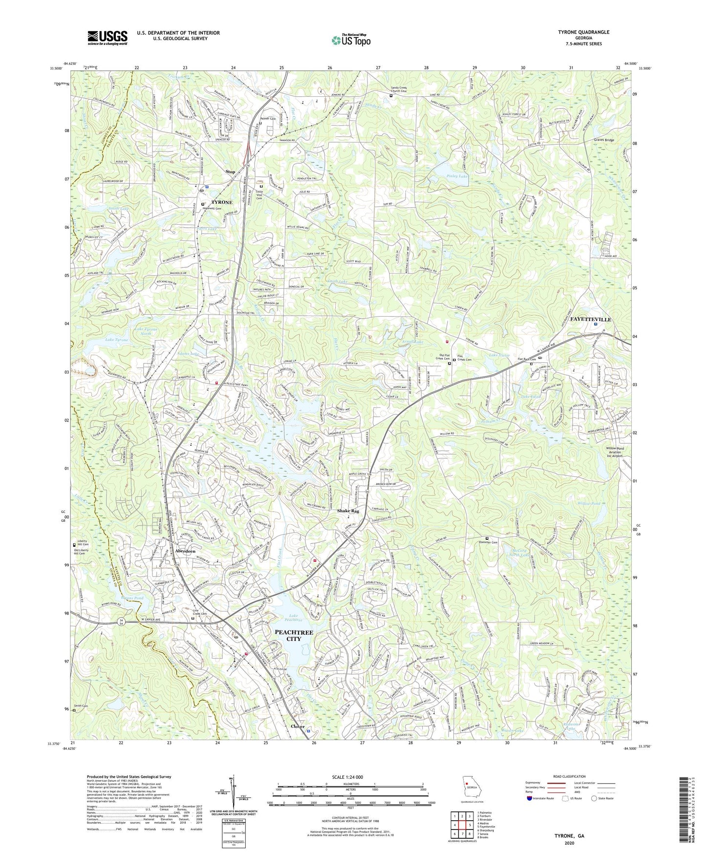
2024 topographic map quadrangle Tyrone in the state of Georgia. Scale: 1:24000. Based on the newly updated USGS 7.5' US Topo map series, this map is in the following counties: Fayette, Coweta. The map contains contour data, water features, and other items you are used to seeing on USGS maps, but also has updated roads and other features. This is the next generation of topographic maps. Printed on high-quality waterproof paper with UV fade-resistant inks.
Quads adjacent to this one:
West: Madras
Northwest: Palmetto
North: Fairburn
Northeast: Riverdale
East: Fayetteville
Southeast: Brooks
South: Senoia
Southwest: Sharpsburg
This map covers the same area as the classic USGS quad with code o33084d5.
Contains the following named places: Aberdeen, Aberdeen Village Shopping Center, Adams Lake, Adams Lake Dam, Arnall Lake, Arnall Lake Dam, Belle Grove, Bennetts Mill Middle School, Braelinn Courts, Braelinn Green, Braelinn Recreation Center, Braelinn Village Shopping Center, Briarhill, Briarwood Acres, Bridger Point, Brookwood, Burnham Woods, Camp Creek Estates, Campers Paradise, Caramore, Center Green, Chestnutfield, City of Peachtree City, Cleveland Elementary School, Clover Reach, Clover Reach Recreation Center, Cobblestone Creek, Country Downs, Crabapple Lane Elementary School, Creekside Crossing Estates, Crestwood Christian Academy, Crossroads Christian School, Dover Square, Eastbrook Office Park, Ebenezer Cemetery, Ebenezer Church, Edgewater, Ellison Family Cemetery, Everhill, Farrs Lake, Fayette County Fire and Emergency Services Station 11, Fayette County Fire and Emergency Services Station 3, Fayette Villa Estates, Fayetteville Carrier Annex Post Office, Fernwood, Fetlock Meadows, First Baptist Church of Tyrone, Fischers Crossroad, Fishers Bank, Flat Creek Cemetery, Flat Creek Church, Flat Creek Country Club, Flat Rock Cemetery, Flat Rock Church, Flat Rock Middle School, Flat Rock School, Gin Branch, Glenloch Recreation Center, Golfview, Governors Walk Shopping Center, Graceland, Graves Bridge, Green Tree Baptist Church, Greensway, Greers Mountain, Groveland, Heritage Farms, Holly Grove Church, Hopewell Academy, Hopewell Cemetery, Hopewell Church, Huddleston Elementary School, Immanuel Bible College and Theological Seminary, J C Booth Middle School, Jennings Yard, Kedron Creek, Kedron Elementary School, Kendron Village Shopping Center, Kingsridge, Lake Edith, Lake Edith Dam, Lake Forest Cove, Lake Forest Glen, Lake Kedron, Lake Kedron Dam, Lake Peachtree, Lake Peachtree Dam, Lake Tyrone, Lake Tyrone Dam, Lake Tyrone North, Lake Tyrone North Dam, Lake Victor, Lake Victor Dam, Lakeside, Landmark Christian School Peachtree City Campus, Ledgewood, Liberty Hill Cemetery, Liberty Hill Church, Liberty Hill School, Line Creek Cemetery, Line Creek Church, Little Creek, Little Vine Cemetery, Little Vine Church, Little Vine School, Magnolia Dam, Magnolia Farms, Magnolia Lake, Marnelle Mobile Home Park, McCord North Dam, McCord North Lake, McCord South Dam, McCord South Lake, McIntosh Amphitheatre, McIntosh Corner, McIntosh High School, North Peachtree Estates, North Town Plaza Shopping Center, Oak Grove Elementary School, Old Flat Creek Cemetery, Old Liberty Hill Cemetery, Overlook, Palmer Cemetery, Parkway Estates, Peachtree City, Peachtree City Elementary School, Peachtree City Fire - Rescue Department Station 81, Peachtree City Fire Department, Peachtree City Fire Department Station 84 Satterthwaite, Peachtree City Industrial Park, Peachtree City Police Department, Peachtree City Post Office, Peachtree City-Tyrone Division, Peachtree Crossing Shopping Center, Peachtree Executive Conference Center, Peachtree Villas, Peachtree Walk, Pebblepocket Park, Pelham Creek, Perry Creek, Persimmon Creek, Piedmont Fayette Hospital, Pinegate, Piney Knoll, Pinley Lake, Pinley Lake Dam, Raintree East, Redwine Lake, Ridgefield, Ridgelake, Riley Recreation Field, Robert Burch Elementary School, Robert J Burch Elementary School, Robinson Wood Estates, Robinsons Bend Estates, Rockspray, Rosemont, Saint Andrews Square, Saint Paul Lutheran School, Sandown Creek, Sandy Creek, Sandy Creek Church, Sandy Creek Church Cemetery, Sandy Creek High School, Sawmill Trace, Shadowood, Shake Rag, Shamrock Park, Shoal Creek, Smith Cemetery, Smith Dam, Smith Lake, Smith Lake Dam, Smiths Crossroads, Smoke Rise Plantation, Spooner Ridge, Spyglass Hill, Stevens Entry Park, Stevens Forest, Stoney Brook Plantation, Stop, Strickland Lake, Strickland Lake Dam, Sweetwater Oaks, Tabernacle Baptist Church, Tapestry, Tar Creek, The Arbors, The Cloister, The Highlands, The Summit, The Terraces, Timberidge, Tinsley Mill Village, Town of Tyrone, Treillage, Trinity Christian School, Twigs Corner, Tyrone, Tyrone Acres, Tyrone Elementary School, Tyrone Library, Tyrone Police Department, Tyrone Post Office, Tyrone Town Hall, Valleywood Corners, Wedgewood, Westpark, Westpark Walk Shopping Center, Whitfield Farms, Wickerhill, Willow Pond, Willow Pond Dam, Willowbend Shopping Center, Windgate Forest, Windsong, Wisdom Woods, Woodsmill, Wynnmeade, Wynns Pond, Wynns Pond Dam, ZIP Codes: 30269, 30290