MyTopo
Fayetteville Georgia US Topo Map
Couldn't load pickup availability
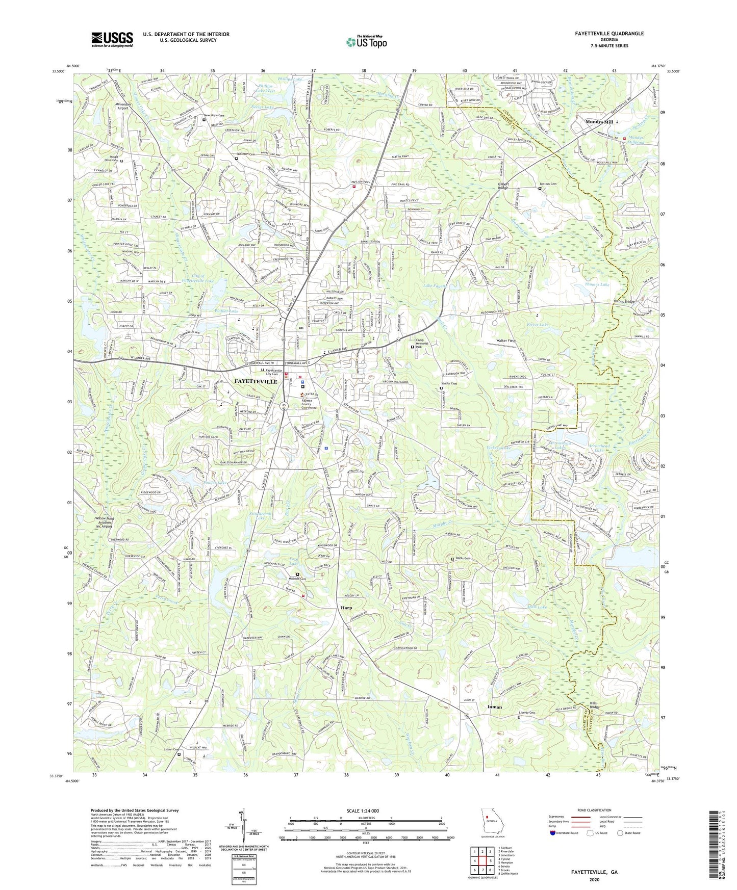
2024 topographic map quadrangle Fayetteville in the state of Georgia. Scale: 1:24000. Based on the newly updated USGS 7.5' US Topo map series, this map is in the following counties: Fayette, Clayton. The map contains contour data, water features, and other items you are used to seeing on USGS maps, but also has updated roads and other features. This is the next generation of topographic maps. Printed on high-quality waterproof paper with UV fade-resistant inks.
Quads adjacent to this one:
West: Tyrone
Northwest: Fairburn
North: Riverdale
Northeast: Jonesboro
East: Hampton
Southeast: Griffin North
South: Brooks
Southwest: Senoia
This map covers the same area as the classic USGS quad with code o33084d4.
Contains the following named places: Adams Airport, Arnolds Grove Church, Arrowhead East Dam, Arrowhead Lake, Arrowhead Lakes, Arrowhead West Dam, Banks Cemetery, Banks Crossing Shopping Center, Banks Station Shopping Center, Beaverdam Creek, Beverly Manor, Bishops Airport, Blakely Woods, Bottom Cemetery, Briarwood Park, Brookcliff, Calebs Meadows, Camp Creek, Camp Memorial Park, Chandler Acres, Chanticleer, City of Fayetteville, City of Fayetteville Lake, City of Fayetteville Lake Dam, Clayton County Fire Department Station 12, Community Church, Cottonwood, Coventry Estates, Cross Creek, Cross Roads, Crossroads School, Deep Forest, Deer Glen Forest, Dixons Bridge, East Fayette Elementary School, Edgefield Baptist Church, Fayette Acres, Fayette Christian School, Fayette County, Fayette County Courthouse, Fayette County Fire and Emergency Services Station 10, Fayette County Fire and Emergency Services Station 4, Fayette County High School, Fayette County Jail, Fayette County Library, Fayette County Marshal's Office, Fayette County Sheriff's Office, Fayette Eightyfive Shopping Center, Fayette Intermediate Elementary School, Fayette Medical Center, Fayette Middle School, Fayette Montessori School, Fayette Pavillion Shopping Center, Fayetteville, Fayetteville Academy, Fayetteville Christian Academy, Fayetteville Christian School, Fayetteville City Cemetery, Fayetteville City Hall, Fayetteville Corners Shopping Center, Fayetteville Division, Fayetteville Elementary School, Fayetteville Fire Department Station 91, Fayetteville Fire Department Station 92, Fayetteville Grade School, Fayetteville Intermediate School, Fayetteville Police Department, Fayetteville Post Office, Fenwyck, Fernway Estates, Fievet Lake, Fievet Lake Dam, First Baptist Church, First United Methodist Church, Ford Dam, Ford Lake, Forest Estates, Forest Hills, Fowler Dam, Fowler Lake, Fowler Lake Dam, Gay Creek, Geese Chant Creek, Gilbert Bridge, Gilberts School, Ginger Cake Creek, Ginger Hills, Glynn Hood Plaza Shopping Center, Grace Christian Academy, Greenlea, Gregory Estates, Harp, Hickory Acres, Hills Bridge, Hood Avenue Primary School, Hudson Plaza Shopping Center, Huntington Creek, Huntington South, Hurricane Creek, Indian Lake, Inman, Inman Elementary School, Inman Post Office, Inman United Methodist Church, Joseph Sams School, Keyland Woods, Kingswood, LaFayette Educational Center Alternative School, LaFayette Educational Center Lafayette School, LaFayette Educational Center Open Campus High School, Lafayette Nursing and Rehabilitation Center, Lake Bennett, Lake Bennett Dam, Lake Fayette, Lakeview Estates, Liberty Cemetery, Lisbon Cemetery, Lisbon Church, Little Flock School, Living Praise Tabernacle, Marilyn Acres, Marion, McBride Cemetery, McIntosh Village, McLendon Airport, Medford Manor, Mills Dam, Mills Lake, Mitchell Estates, Morning Creek, Mount Olive Cemetery, Mount Olive Church, Mundys Mill, Mundys Mill Dam, Mundy's Mill High School, Mundys Millpond, Murphy Creek, Nash Creek, Neelys Lake, Neelys Lake Dam, New Hope Cemetery, New Hope Church, Oak Hills, Old Landmark Church, Pace Christian School, Phillips Lake, Phillips Lake Dam, Phillips Lake Dam West, Phillips Lake West, Ponderosa, Pye Dam, Pye Lake, Quail Hollow, Ramah Baptist Church, Rest, Rising Star Montessori School, River's Edge Elementary School, Robinson Cemetery, Robinson School, Rolling Meadows Estates, Sams Lake, Sams Lake Dam, Sandy Creek, Sara Harp Minter Elementary School, Shannon, Sharon Heights, Shoal Creek, Spring Hill Elementary School, Stinchcomb Lake, Stinchcomb Lake Dam, Stubbs Cemetery, Swamp Creek, Thames Lake, Thames Lake Dam, The Summit Church, Tunis Trace, Union Chapel, Vickery Dam, Vickery Lake, Walker Dam, Walker Field, Walker Lake, Wellborn Lake, Wellborn Lake Dam, Wellington Manor, Whipporwill Ridge, Whitewater High School, Whitewater Middle School, Willow Pond Aviation Inc Airport, Windsor Estates, Winterthur Woods, ZIP Codes: 30214, 30215, 30238