MyTopo
Jonesboro Georgia US Topo Map
Couldn't load pickup availability
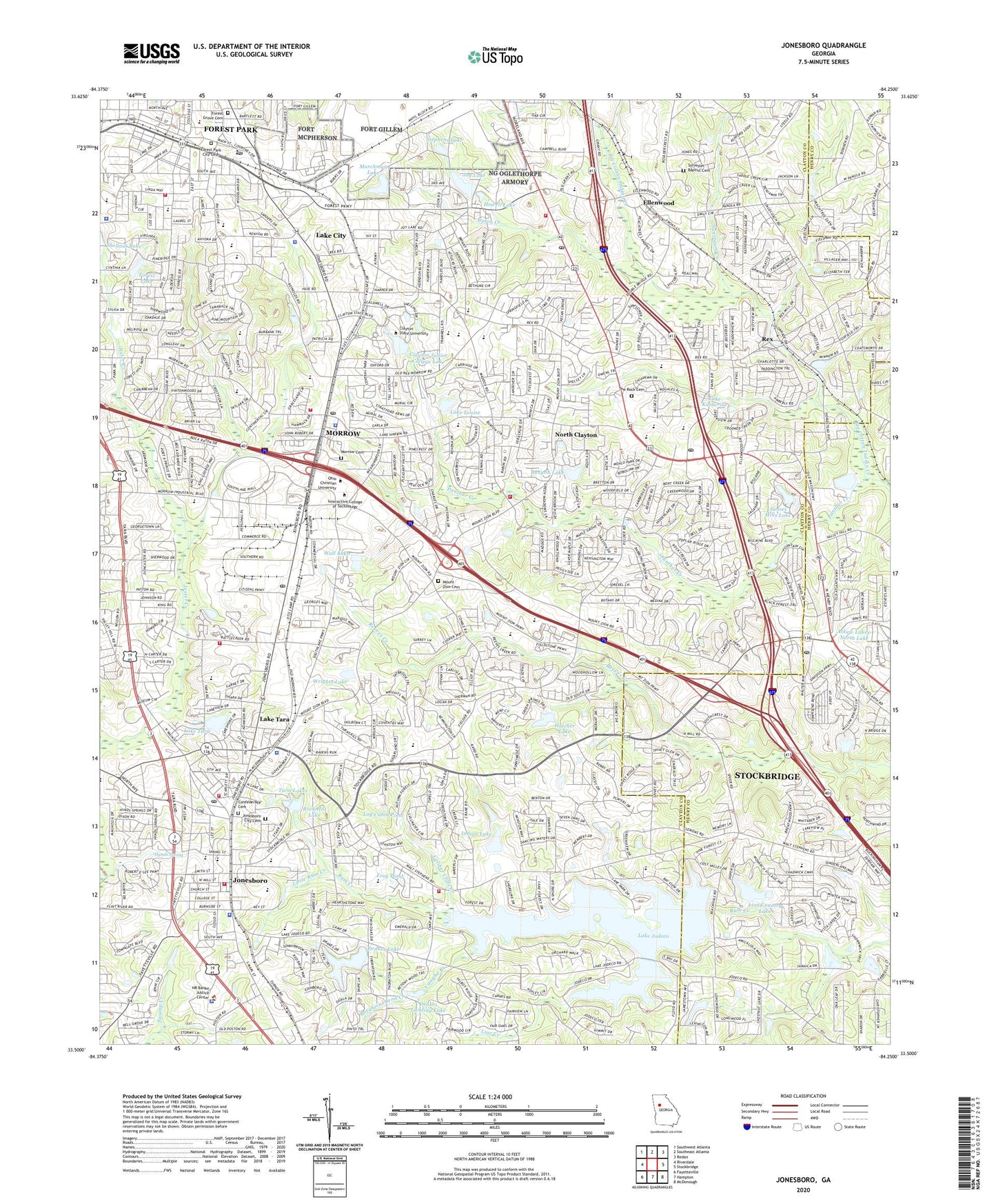
2024 topographic map quadrangle Jonesboro in the state of Georgia. Scale: 1:24000. Based on the newly updated USGS 7.5' US Topo map series, this map is in the following counties: Clayton, Henry. The map contains contour data, water features, and other items you are used to seeing on USGS maps, but also has updated roads and other features. This is the next generation of topographic maps. Printed on high-quality waterproof paper with UV fade-resistant inks.
Quads adjacent to this one:
West: Riverdale
Northwest: Southwest Atlanta
North: Southeast Atlanta
Northeast: Redan
East: Stockbridge
Southeast: McDonough
South: Hampton
Southwest: Fayetteville
This map covers the same area as the classic USGS quad with code o33084e3.
Contains the following named places: Ace Mobile Home Park, Adamson Middle School, Allendale Heights, Amber Wood Estates, Ambleside, Angel Creek, Anvil Block School, Ash Street Center, Ash-Morrow Plaza Shopping Center, Askew Lakes-North Dam, Askew Lakes-North Lake, Atlanta General Depot, Atlanta Southern Industrial Park, B C Haynie Elementary School, Babb Middle School, Barcelona Estates, Beverly Hills, Blueridge Mountain Mobile Home Park, Bobilin Estates, Botanical Bend Creek, Bretton Woods, Brown Rock Bottom Creek, Bunyon Lake, Bunyon Lake Dam, Burkshire, Caliber Cliffs Creek, Canterbury Woods, Carol Woods, Charlotte Woods, Chestnut Lake Estates, City of Forest Park, City of Jonesboro, City of Lake City, City of Morrow, Clayton Commons Shopping Center, Clayton County, Clayton County Medical Center, Clayton Heliport, Clayton High School, Clayton Junior College Lake, Clayton Junior College Lake Dam, Clayton Manor, Clayton Plaza Shopping Center, Clayton State University, Clearbrook, Confederate Cemetery, Consolidated School, Creek Hollow, Creekwood Estates, Creekwood Village Shopping Center, Crossroads South Shopping Center, Devonshire, Dogwood Acres, Drakes Lake, Drakes Lake Dam, Drakes Landing, Drakes Landing Dam, Drakes Landing Lake, East Clayton Elementary School, Edgemoor Manor, Ellenwood, Ellenwood Homes, Embrey Hills, Emerald Hills, Fairlane, Faith Hope and Charity Nursing Home, Fernwood, Fielder Manor, Flint River Shopping Center, Forest Grove Cemetery, Forest Lake, Forest Park, Forest Park City Cemetery, Forest Park City Park, Forest Park High School, Forest Park Middle School, Forest Park-Morrow Division, Fort Gillem, Fountain Elementary School, Foxfield, Freeway Junction Shopping Center, Frog Pond, Giant City South Shopping Center, Glenn Devon, Green Meadows, Hale Haven Shopping Center, Hammock Center Shopping Center, Harbin Acres, Hatcher Lake, Hatcher Lake Dam, Haven Park, Heather Lynn, Hickory Hills, Hidden Hollow, Hidden Springs Brook, Holiday Hills, Homestead, Howell Lake, Hynds Spring, Indian Hill Estates, Indian Lake, Indian Lake Dam, J W Arnold Elementary School, Jarrard, Jester Creek, Jonesboro, Jonesboro City Cemetery, Jonesboro Corners Shopping Center, Jonesboro Historic District, Jonesboro Medical Center, Jonesboro Middle School, Jonesboro Shopping Center, Joy Lake, Joy Lake Dam, Joy Lake West, Joy Lake West Dam, Katherine Valley, Kilpatrick Elementary School, Knollwood, Kunuga Hills, Lake City, Lake City Crossing Shopping Center, Lake Harbin Plaza Shopping Center, Lake Jodeco, Lake Katherine, Lake Katherine Dam, Lake Louise, Lake Louise Dam, Lake Spivey, Lake Spivey Dam, Lake Spivey Estates, Lake Tara, Lake Tara Dam, Lee Park, Line Creek, Lion Country Lake, Lion Country Lake Dam, Little Rum Creek, Log Cabin Pond, Log Cabin Pond Brook, Lowland Creek, Maddox Plaza Shopping Center, Maddox Road Park, Maple Grove, Marchman Lake, Marchman Lake Dam, Mayday, Mays Corner Shopping Center, Mays Crossing Shopping Center, Meadowview Acres, Minska Pinska Dam, Minska Pinska Lake, Morris Army Airfield, Morrow, Morrow Cemetery, Morrow Industrial Park, Morrow Pavillion Shopping Center, Morrow Police Station, Mossflorinstone Creek, Mount Zion Cemetery, Mount Zion Shopping Center, North Clayton, North Jonesboro School, Oak Forest, Oak Ridge, Old South, Orchard Hills, Panther Creek, Paradise Park, Park Forest, Pinebrook Heights, Pinecrest Forest, Planters Walk Shopping Center, Pooles Mobile Home Park, Red Oak, Red Oak Elementary School, Rex, Reynolds Nature Preserve, Richmond Pond, Roberts Brook, Rock Hill Lake, Rocky Creek, Rolling Meadows, Rum Bridge Estates, Rum Creek Park, Shellnut Lake, Sherwood Forest, South Expressway Airport, Southlake Festival Shopping Center, Southlake Mall Shopping Center, Southway Shopping Center, Spivey Chase, Springfield, Springview, Stagecoach Manor, Stephens Lake, Stephens Lake Dam, Stockbridge Village Shopping Center, Sun Valley, Sunset Hills, Sunset Hills Dam, Sunset Hills Lake, Suwanee Lake, Suwanee Lake Dam, Sweetgum Creek, Sylvester Baptist Cemetery, Tar Creek Mini-Park, Tara Shopping Center, Tara Stadium, The Inlet, The Rock Cemetery, Thornton Estates, Tiffany Hills, Trammel Creek, Twin Lakes, University Estates, Upton Creek, Vaughn Branch, Village Square Shopping Center, Vinton Woods, Wall Dam, Wall Lake, Weybridge, Wildwood Estates, Wilkshire Estates, Windhaven Plantation, Woodfield, Woodlawn Acres, Woodstone, Wrights Lake, WSSA-AM (Morrow), ZIP Codes: 30236, 30260, 30273, 30297