MyTopo
Hampton Georgia US Topo Map
Couldn't load pickup availability
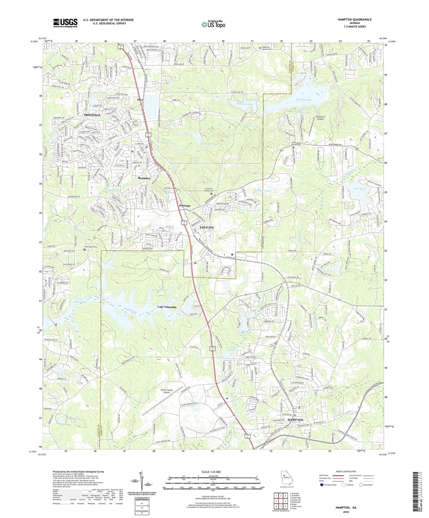
2024 topographic map quadrangle Hampton in the state of Georgia. Scale: 1:24000. Based on the newly updated USGS 7.5' US Topo map series, this map is in the following counties: Clayton, Henry. The map contains contour data, water features, and other items you are used to seeing on USGS maps, but also has updated roads and other features. This is the next generation of topographic maps. Printed on high-quality waterproof paper with UV fade-resistant inks.
Quads adjacent to this one:
West: Fayetteville
Northwest: Riverdale
North: Jonesboro
Northeast: Stockbridge
East: McDonough
Southeast: Luella
South: Griffin North
Southwest: Brooks
This map covers the same area as the classic USGS quad with code o33084d3.
Contains the following named places: Atlanta International Raceway, Atlanta Speedway Airport, Babb Mill, Bear Creek Airport, Bear Creek Church, Beaver Dam, Beaver Lake, Bible Baptist Christian School, Black Dog Creek, Bonanza, Bonanza Census Designated Place, Bonanza Shopping Center, Booths Crossing Shopping Center, Calvary Baptist School, Camp Calvin, Camp Calvin Dam, Camp Calvin Lake, Camp Orr Dam, Camp Orr Lake, Castor Creek, Cindy Lake Dam, City of Hampton, City of Lovejoy, Clayton County Fire Department Station 10, Clayton County Fire Department Station 6, Clayton County Police Department South Clayton Precinct, Clayton County Prison, Clayton County Regional Law Enforcement Academy, Clover Ranch Mobile Home Park, Club Dam, Club Lake, Cougar Creek, County Line Church, County Line Church Cemetery, County Line Lake, County Line Lake Dam, Crawford - Dorsey Cemetery, Crystal Springs, Deerfield Landing Airport, Diamond S Airport, Divine Faith Ministries School, Dutchtown Elementary School, Dutchtown High School, Feagins Dam, Feagins Lake, Fellowship Church of God, Flint River School, Fortson, Fortson Memorial Library, Foster Lake, Hampton, Hampton Church of God, Hampton City Hall, Hampton City Park, Hampton Division, Hampton Elementary School, Hampton Police Department, Hampton Post Office, Hampton Road Church, Harbin Dam, Harbins Lake, Hastings, Hawthorne Elementary School, Henry County Fire Department Station 5, Henry County Hampton Precinct Police Station, Henry County Industrial Park, Hermans Lake, Hermans Lake Dam, Hidden Hollow, Iron Gate, Irondale, Irondale Census Designated Place, James H Brown Elementary School, Jonesboro Church of God, Jonesboro Division, Kemp Elementary School, Kemp Primary School, Lake Amah Lee, Lake Amah Lee Dam, Lake Chase, Lake Cindy, Lake Cindy Estates, Lake Cindy First Baptist Church, Lake Erma, Lake Erma Dam, Lake Shamrock Dam, Lake Talmadge, Lake Talmadge Dam, Lake Twelve Oaks, Laurus Technical Institute, Liberty Hill Baptist Church, Liberty Hill School, Lovejoy, Lovejoy City Hall, Lovejoy High School, Lovejoy Middle School, Lovejoy Post Office, Lovejoy Station Shopping Center, Martha K Glaze Regional Youth Detention Center, Moores Temple Baptist Church, Mount Carmel Church, Mount Carmel Elementary School, Mount Carmel Estates, Mundy's Mill Middle School, New Hope Cemetery, New Hope Church, Noahs Ark Church, Noahs Ark Church Cemetery, Noahs Church, Orrs, Orrs Church, Panhandle Park, Progress School, Sams Lake, Sams Lake Dam, Schinder Dam, Schinder Lake, Shamrock Lake, Shiloh Church, Sinback Dam, Sinback Lake, South Atlanta Church of Christ, Terrell Lake, The Springs, Twelve Oaks Lake, Twelve Oaks Lake Dam, Walnut Creek, West Hampton, White River Farm Airport, Willow Bend, Woodlawn, ZIP Codes: 30228, 30250