MyTopo
Lawrenceville Georgia US Topo Map
Couldn't load pickup availability
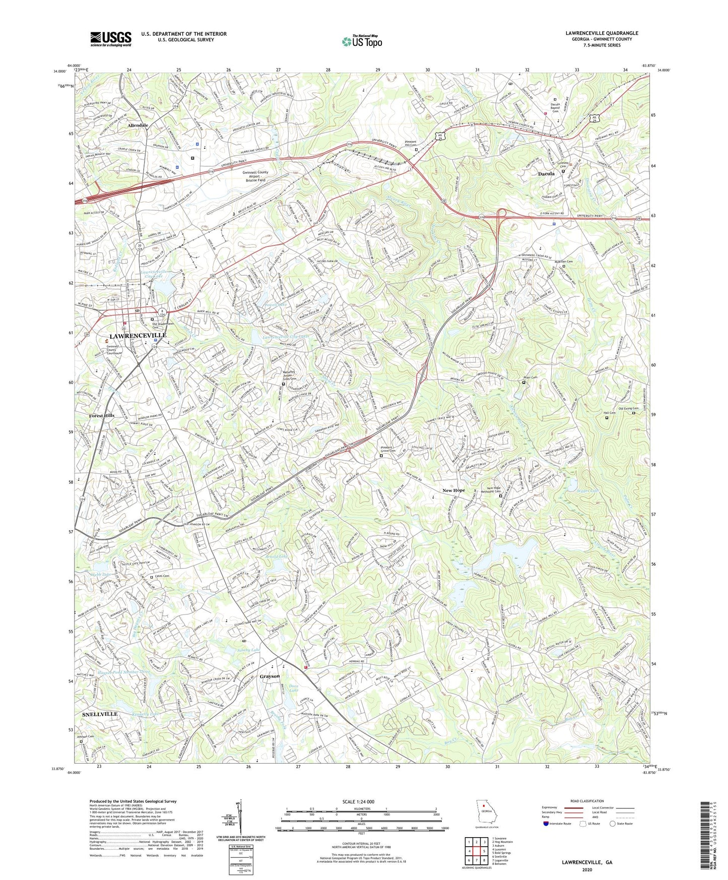
2024 topographic map quadrangle Lawrenceville in the state of Georgia. Scale: 1:24000. Based on the newly updated USGS 7.5' US Topo map series, this map is in the following counties: Gwinnett. The map contains contour data, water features, and other items you are used to seeing on USGS maps, but also has updated roads and other features. This is the next generation of topographic maps. Printed on high-quality waterproof paper with UV fade-resistant inks.
Quads adjacent to this one:
West: Luxomni
Northwest: Suwanee
North: Hog Mountain
Northeast: Auburn
East: Bold Springs
Southeast: Between
South: Loganville
Southwest: Snellville
This map covers the same area as the classic USGS quad with code o33083h8.
Contains the following named places: Acadia Woods, Alcova Church, Alcova Elementary School, Alcovy Forest, Allendale, Appalachee Church, Archer High School, Arnold Dam, Arnold Lake, Aviation Institute of Maintenance, Carmel East, Cates Cemetery, Cedar Creek, Central Church, Central Gwinnett High School, Central High School, Chestnut Grove Church, Church of God, City of Dacula, City of Grayson, City of Lawrenceville, Cobb County Station 6 Fire Station, Couch Middle School, County Police Heliport, Crogan Street Post Office, Dacula, Dacula Baptist Cemetery, Dacula City Hall, Dacula Elementary School, Dacula High School, Dacula Marshal's Office, Dacula Middle School, Dacula Park, Dacula Post Office, Dam Y3, Dove Dam, Dove Lake, East Shadowlawn Cemetery, Ewing Chapel Baptist Church Cemetery, Ewings Chapel, First Baptist Church of Dacula, First Baptist Church of Grayson, First Baptist Church of Lawrenceville, First United Methodist Church of Lawrenceville, Flight School of Gwinnett, Forest East, Forest Hills, Forest River, GDPS - Police Heliport, Grace Bible Church, Grayson, Grayson City Hall, Grayson Elementary School, Grayson Post Office, Grayson Quarry, Grayson Recreation Center, Grayson United Methodist Church, Graystone, Graystone North, Gunter Estates, Gwinnett County Airport - Briscoe Field, Gwinnett County Correctional Institution, Gwinnett County Courthouse, Gwinnett County Detention Center, Gwinnett County Fairgrounds, Gwinnett County Fire and Emergency Services Headquarters, Gwinnett County Fire and Emergency Services Station 15, Gwinnett County Fire and Emergency Services Station 16, Gwinnett County Fire and Emergency Services Station 8, Gwinnett County Police Department, Gwinnett County Police Department East Precinct, Gwinnett County Sheriff's Office, Gwinnett History Museum, Gwinnett InterVention Education Center, Gwinnett Intervention Education Center East, Gwinnett Public Utilities Central Facility, Gwinnett Square Shopping Center, Hall Cemetery, Haynes Pond Number Three, Hebron Christian Academy High School Campus, Hebron Church, Hi-Hope Training Center, Hill Square Shopping Center, Hinton Methodist Church, Hooper Renwick School, Hopkins Creek, J G Dyer Elementary School, J P McConnell Middle School, Johnson Cemetery, Kennerly Dam, Kennerly Lake, Lawrenceville, Lawrenceville Campground, Lawrenceville City Dam, Lawrenceville City Lake, Lawrenceville City Park, Lawrenceville Corners Shopping Center, Lawrenceville Elementary School, Lawrenceville Library, Lawrenceville Mall Shopping Center, Lawrenceville Middle School, Lawrenceville Police Department, Lawrenceville Police Station, Lawrenceville School, Lawrenceville Senior Center, Lawrenceville Square Shopping Center, Lawrenceville Station, Lawrenceville Town Center Shopping Center, Loveless Cemetery, Lovin Elementary School, Mahaffey - Jordan - Giles Cemetery, Martin Chapel, McConnell Middle School, McMillan Cemetery, Mount Zion Church, New Canaan Baptist Church, New Hope, New Hope Baptist Church, New Hope Methodist Cemetery, New Hope Methodist Church, Oakdale Woods, Oakland Meadow School, Oaklawn Chapel, Old Ewing Cemetery, Old Shadowlawn Cemetery, Ozora Church, Pharr Cemetery, Pinehurst Trace, Pleasant Grove Cemetery, Pleasant Grove Church, Pleasant Hill Cemetery, Powell Dam, Powell Lake, Rhodes Jordan Park, Robin Ridge, Saddleback Estates, Sandlewood, Scenic Plaza Shopping Center, Shoal Creek, Simonton Elementary School, Soseby Dam, Soseby Lake, Starling Elementary School, Stone Mountain Christian School, Summitridge Psychiatric Hospital, The Tabernacle, Timbercrest, Tribble Mill Park, Village Gate, W J Cooper Elementary School, Wages Lake, Walnut Grove Church, Waterton, Waverly Woods, Webb Lake, WPLO-AM (Grayson), ZIP Codes: 30017, 30019, 30045, 30046