MyTopo
Suwanee Georgia US Topo Map
Couldn't load pickup availability
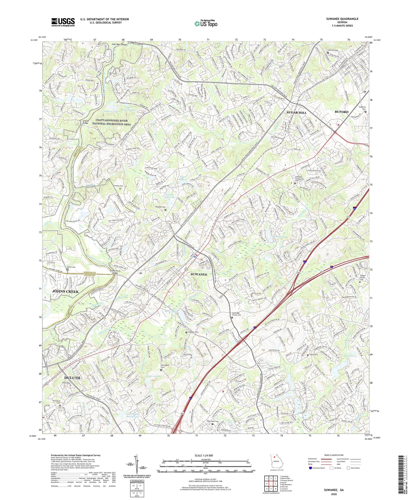
2024 topographic map quadrangle Suwanee in the state of Georgia. Scale: 1:24000. Based on the newly updated USGS 7.5' US Topo map series, this map is in the following counties: Gwinnett, Forsyth, Fulton. The map contains contour data, water features, and other items you are used to seeing on USGS maps, but also has updated roads and other features. This is the next generation of topographic maps. Printed on high-quality waterproof paper with UV fade-resistant inks.
Quads adjacent to this one:
West: Duluth
Northwest: Cumming
North: Buford Dam
Northeast: Flowery Branch
East: Hog Mountain
Southeast: Lawrenceville
South: Luxomni
Southwest: Norcross
This map covers the same area as the classic USGS quad with code o34084a1.
Contains the following named places: Abbey Hill, Arbor Trace, Ashmore Lake, Ashmore Lake Dam, Ashton Square Shopping Center, Bennett Creek, Berry Lake, Berry Lake Dam, Brandon Cemetery, Brushy Creek, Buford, Buford Church of God, Buford City Hall, Buford Crossroads Shopping Center, Buford Horizons Mobile Home Park, Buford Hospital, Buford Mall Shopping Center, Buford Nature Preserve, Buford Police Station, Buford Post Office, Buford Precinct Heliport, Buford-Sugar Hill Division, Carrols Crossing, Casteel Lake, Casteel Lake Dam, Centurion Hills, Chattahoochee Mobile Home Park, Christ Our Light Church, Church of Christ at Buford, City of Sugar Hill, City of Suwanee, Collins Ferry, Collins Hill High School, Collins Hill Library, Collins Hill Road County Park, Connolly Cemetery, Country Park, Crayfish Creek, Creekland Middle School, Dam Y16, Dean Road Cemetery, Deerwood, Dick Creek, Douglass Cemetery, Duluth Montessori School Sugarloaf Campus, Faith Church, Falconcrest, First Baptist Church of Buford, First Baptist Church of Sugar Hill, First United Methodist Church, First United Methodist Church of Buford, Fish Weir Shoals, Frontier Forest, George Pierce County Park, Gilberts Ferry, Grace Church, Greater Gwinnett Church, Gwinnett County Fire and Emergency Services Station 13, Gwinnett County Fire and Emergency Services Station 14, Gwinnett County Fire and Emergency Services Station 21, Gwinnett County Fire and Emergency Services Station 7, Gwinnett County School, Heritage Church, Herrington Cemetery, Hickory Hills, Hill Top Shopping Center, Hillcrest Cemetery, Hopewell Church, Horizon Christian School, Horizon Technology Distribution Center, Horizon Village Shopping Center, Huntington Place Shops, Ivy Creek, Jackson Square, James Creek, Kemp Cemetery, Kingdom Hall, Lake Louella, Lake Louella Dam, Lake Perrin, Level Creek, Level Creek Church, Level Creek Elementary School, Liberty Church, Lighthouse Church, Littles Ferry Bridge, Lockridge Family Cemetery, Maple Ridge, McGinnis Ferry Shopping Center, Mill Creek, North Gwinnett High School, North Pointe, Number Gate Lake, Number Gate Lake Dam, Oak Meadow Montessori School, Oak Village, Old Peachtree Church, Old Suwanee Baptist Church School, Old Suwanee Christian School, Old Suwanee Church, Old Suwanee Estates, Parsons Elementary School, Peachtree Ridge High School, Peachtree Road Baptist Church, Perrin Country Club, Pine Ridge Country Club Estates, Richard Hull Middle School, River Trail Middle School, Riverside Church, Riverside Elementary School, Riverwatch Middle School, Robinson Park, Rock Springs Elementary School, Santa Monica Catholic School, Settles Bridge, Settles Bridge Elementary School, Shadowbrook Church, Sims Lake, Sims Lake Dam, Strickland Cemetery, Sudderth Cemetery, Sugar Hill, Sugar Hill Christian Academy, Sugar Hill City Hall, Sugar Hill Elementary School, Sugar Ridge, Sugarloaf Area Elementary School, Sugarloaf Area High School, Suwanee, Suwanee City Hall, Suwanee Community Cemetery, Suwanee Creek, Suwanee Elementary School, Suwanee Farms, Suwanee First Baptist Church, Suwanee Parish United Methodist Church, Suwanee Police Department, Suwanee Post Office, Suwanee Training Center, Suwanee-Duluth Division, T Carl Buice School, Teague Family Cemetery, Trinity Church, Union Church, Upper Ashmore Lake, Upper Ashmore Lake Dam, Upper Rollins Ranch Dam, Upper Rollins Ranch Lake, Victory in Jesus Christ Church, Village Square Shopping Center, Walnut Grove Elementary School, Watershed Y17 Dam, Watershed Y17 Lake, Whitlock Farms, Wilbanks Lookout Tower, Yerkes Primate Center, Young Cemetery, ZIP Code: 30024